All Activity
- Past hour
-

Pittsburgh/Western PA WINTER ‘25/‘26
TimB replied to Burghblizz's topic in Upstate New York/Pennsylvania
With these trends I’m starting to get nervous this goes the other direction and we mix to rain. Tale as old as time. -

Central PA Winter 25/26 Discussion and Obs
canderson replied to MAG5035's topic in Upstate New York/Pennsylvania
I don’t think it’ll be but winds. Breezy but not 35+. I’ll let someone way smarter correct me if needed! -

Central PA Winter 25/26 Discussion and Obs
mahantango#1 replied to MAG5035's topic in Upstate New York/Pennsylvania
BRRR! -

Possible Record Breaking Cold + Snow Sunday 1/25 - Tuesday 1/27
Tatamy replied to TriPol's topic in New York City Metro
The NAM can probably barely contain its excitement over being able to work that warm nose in another day or so. -
If DC gets a foot and the NW burbs get 2 feet, I am not sympathetic to those inside the Beltway. I lived in PG for about 30 years, know the drill..
-
Central PA Winter 25/26 Discussion and Obs
canderson replied to MAG5035's topic in Upstate New York/Pennsylvania
6 was my low. It’s funny the gfs had everyone questioning suppression and 12 hours later everyone is concerned about amplification -
Did you just cancel the storm
-
Mine refused the rolling hills of Frederick County, MD so we are moving to Calvert Hoping for one last super MoCo-HoCo band from this storm before I start hanging out on the lower southern MD/eastern shore thread
-
If you are in central and southern Va get your supplies now, you may not have power for a while and brutal cold coming. Someone down there is getting a brutal ice storm.
-

Southern MD / Lower Eastern Shore weather discussion
SnowtoRain replied to PrinceFrederickWx's topic in Mid Atlantic
Pointing more towards a climo based storm. Not sure if I buy >.5" of freezing rain the Euro wants to give the midshore. GFS has been showing the typical subsidence that sets up over the Eastern Shore. Sounds like from NOAA discussion in the main thread they are still waiting to verify the north trend with better data, so we wait. Perhaps this evening we can start getting a better handle on potential amounts and p-type. -
Rob I thought I had it rough over here at +4 stay warm you guys and gals in " the sticks"
-

January 2026 regional war/obs/disco thread
JKEisMan replied to Baroclinic Zone's topic in New England
And that’s 10:1 ratios. Easily 1+ ft across SNE with ratios. EPS putting up close to 1” qpf up to 144 hrs. -
De-amping as we get to day 3-4 has been a trend all year. Let’s see how this one goes with an actual STJ component
-

Central PA Winter 25/26 Discussion and Obs
Voyager replied to MAG5035's topic in Upstate New York/Pennsylvania
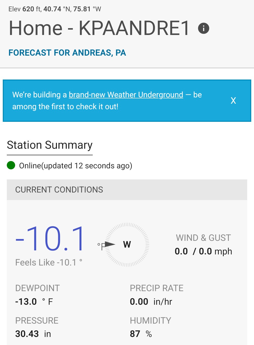
Usually you are colder than me. Today's a bit different. Crazy cold at our shop, though. Got down to -10 there.
-

January 2026 regional war/obs/disco thread
RUNNAWAYICEBERG replied to Baroclinic Zone's topic in New England
Too soon. PF on standby… -
I'm heading to Linville Gorge and reflect.
-
You know who is going to say how that's a step back
-

1/23/26-1/25/26 Winter Storm Thread
Holston_River_Rambler replied to AMZ8990's topic in Tennessee Valley
I 100% could be wrong, but I thought someone in NWS told it which ones to favor in its average? -

January 2026 regional war/obs/disco thread
mreaves replied to Baroclinic Zone's topic in New England
Some of us would be fine with it over the canal. -
Obviously this is a very anomalous event, so maybe the usual rules don’t apply. But I’m keeping some otherwise very durable seasonal and La Niña patterns in my mind: short-term deamplification, suppressing SE ridge, destructive interference from the northern jet, and drier reality than modeled.
-

Possible Record Breaking Cold + Snow Sunday 1/25 - Tuesday 1/27
MJO812 replied to TriPol's topic in New York City Metro
Looks like it does after a foot of snow. Still time for shifts. -
The feature which makes or breaks the storm is less than 60 hours from making its move out of the SW. Models should be able to better predict how quickly it ejects east and how it phases with the NS piece today.
-
1/23/26-1/25/26 Winter Storm Thread
Holston_River_Rambler replied to AMZ8990's topic in Tennessee Valley
Someone on southernwx mentioned Dec 5 2002 as a potential analog: There are some differences, but I'm not sure its totally off the table -

January 2026 regional war/obs/disco thread
Damage In Tolland replied to Baroclinic Zone's topic in New England
Is there any chance this trends so far that it ends up icestorm SNE and snow NNE? -
We have been pretty lucky with moderate to heavy(6-10") all snow events over the last several years on the coastal plain, including 2 last winter. Probably due for a snow to sleet deal. Hopefully not freezing rain.