All Activity
- Past hour
-
Maybe I'm not awake enough for this, but, that's not how this works. I don't see which magnitude scale is being used, so I'll just speak in general terms. An increase of one in a magnitude scale means the amplitude of the wave increased by 10. An increase of one means 32 times as much energy is released. Dr. Viterito is smoking crack. You can't look at the number of earthquakes of a given magnitude and interpolate how many smaller ones there were.
-
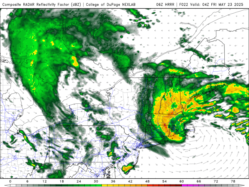
it looks like rainfall totals will have underperformed for nyc..
-
yep-the Nam and Euro were too far west in that too
-
Looks like the heaviest will be east of Newark NJ?
-
Seems looking at radar that it’s a little ahead of schedule and a little east?
-
39 degrees this morning here in the Poconos, with showers. Is it October or late May? I actually had to turn the heat on last night as my house was 58 degrees. Something I rarely do this late into the year. Ridiculous lol. The days and days of rain is downright depressing at this point.
-
I can’t wait till we furnace right through next winter
-
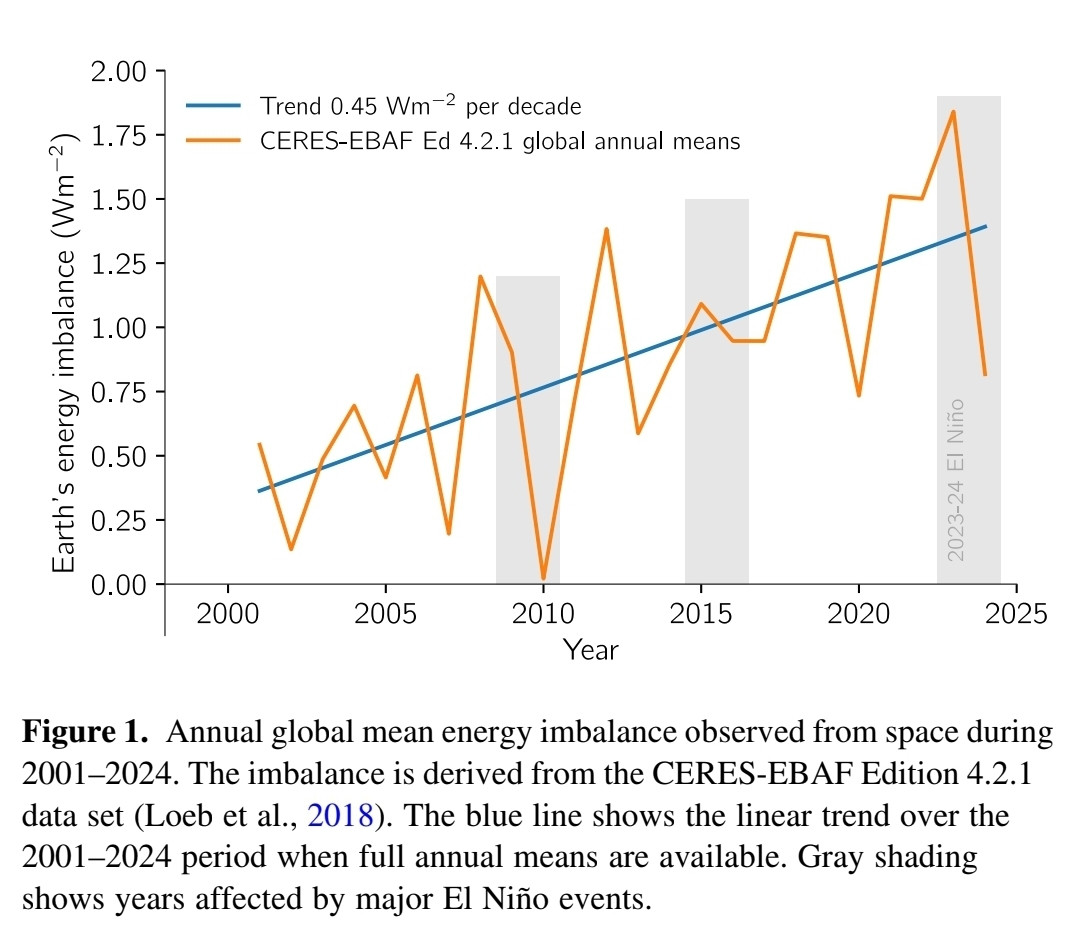
Shows the guy is in serious climate denial. When it comes to climate, the sun swamps the earth. Always has and always will. The big problem we have now is more energy coming in from the sun than is radiated away. A large and growing imbalance at the top of the atmosphere, roughly 0.5% of the suns energy, year after year after year. Crazy when you consider that the energy leaving the earth is rising rapidly as the world warms. If seismic was warming the earth, the earth would be warming from the inside out not the outside in.
-
Juno Jr verifying east
-
47 degrees here. LGA has the best chance of beating the record, they are at 49 degrees right now and temps will be pretty uniform today.
-
I'm not sure how much it rain last night but it was definitely significant. It's actually pouring again right now. RIP to the year long drought. It looks like we swamp next week too.
-
0.51” overnight 0.83” total so far 54 and light rain
-
41.5 here we take!
-
0.91", 4.97" for the month
-
37° and rain for Mitch. Awful. Ditty not far behind.
-
This happens every spring once the gradient between Siberia and the WPAC relaxes. So this is the normal seasonal weakening of the Pacific Jet allowing more cutoff lows. But even if this was January there would still be mixing issues near the coast since the primary low cut to the Great Lakes before the coastal got going. This would have been a great snowstorm for the interior regions and ski resorts.We can remember the big Nor’easter back on April 4th last spring. It may also be easier to get the height rises near Iceland in the spring for more NAO dominant blocking due to the North Atlantic Jet also weakening during the spring as the gradient between the Arctic and equator weakens. Recent studies have found the North Atlantic winter jet has been getting faster. 4-4-24 Nor’easter
-
All our stations have a shot at the new low max record for 5-22. EWR….56° NYC…..54° LGA…..57° JFK……55° ISP……54° BDR….54° HPN….54°
-
Another half inch since midnight. Approaching 5” for the month.
- Today
-
45° and dry for the moment. Looks like a DTR of about 3° today.
-
0.90" for this event and approaching 9" for the month.
-
.73 so far here in 21057. Respectable
-
Columbia east side: 0.55” from 8:30am Wed to 5:30am Thurs Total for event so far 0.94”
-
Days and days....
-
As CoastalWx has already lamented I bet, "why couldn't we get this 3 months ago!!!" Set up synoptically is ideal for a big snowstorm, but can't fight that it is late May. Still, I bet there will be some S+ surprises in ME/NH/VT. Excellent comma head and low track w/ max dynamical cooling aloft as 500 low passes right over the region. S/w swings around the base of the mean trough and does 90 deg negative tilt w/ a W-E elliptical, oval-sharped, closed 500 low -- about as classic as it can get for "backlash."
-
Yes it looks depressing next week...again! LONG TERM /SUNDAY THROUGH WEDNESDAY/... If you squint really hard at the upper air charts for Sunday, you might be able to convince yourself that upper level flow is becoming slightly less trough-y, but that`s probably just wishful thinking. We are growing less optimistic to see any marked improvement before Monday. The recent blocking pattern has proven to be rather persistent and in no hurry to unravel. The cyclonic flow and cool temps aloft should translate into a good deal of cloud cover with POPs peaking during the afternoon hours coincident with diurnal heating. Precip probs should bottom on Monday before ramping higher into Tuesday-Wednesday. Models are coming into better agreement in tracking the southern stream wave farther to the north. There are even signs that the briefly split-stream flow will try to close off into another upper low in the Great Lakes/Ohio Valley region by the middle of next week. So it appears the cool and wet pattern will continue into the end of the month with no signs of summer weather on the horizon (meteorological summer begins on June 1).