All Activity
- Past hour
-
We checked out the Villages, several of our friends moved there, in the winter it's great down there, so we went in the summer to get a feel for the heat, no way, too freaking hot and humid. Decided on Maine instead.
-

June 8 Southern Plains Severe Outbreak
Powerball replied to Powerball's topic in Central/Western States
FWD presents a possible fly in the ointment with respect to high-end severe potential. It wouldn't be a DFW severe weather event if there wasn't one. Take it for what it's worth... Scenario 1 has already been discussed ad-nauseam -
Something had it by the tail and he got away.
-

Central PA Summer 2025
Mount Joy Snowman replied to Voyager's topic in Upstate New York/Pennsylvania
Gorgeous afternoon setting up here after 1-2 hours of rain brought about an eighth of an inch. -
for suffolk county not until after 4 pm
-
It was perfect until about 5 minutes ago lol
-
we need to put all this excess moisture on the upcoming lunar colony and the future colony on Mars, they'll need it MUCH more than we do.
-
Rotation north of Fredericksburg? Sent from my Pixel 9 Pro XL using Tapatalk
-
it finally got cloudy here at 3 pm
-
I think July 1966 was hotter, it had the highest temperature of record at both LGA (107) and JFK (104) and EWR (105) which was tied twice in 1993 and later broken in 2011 (108). NYC somehow only recorded a maximum of 103 in 1966, which was 4 degrees lower than LGA and a degree lower than JFK.
-
Received exactly .1" of rain from the first batch. Much more fell to my south.
-
Rain moving up into EPA
-
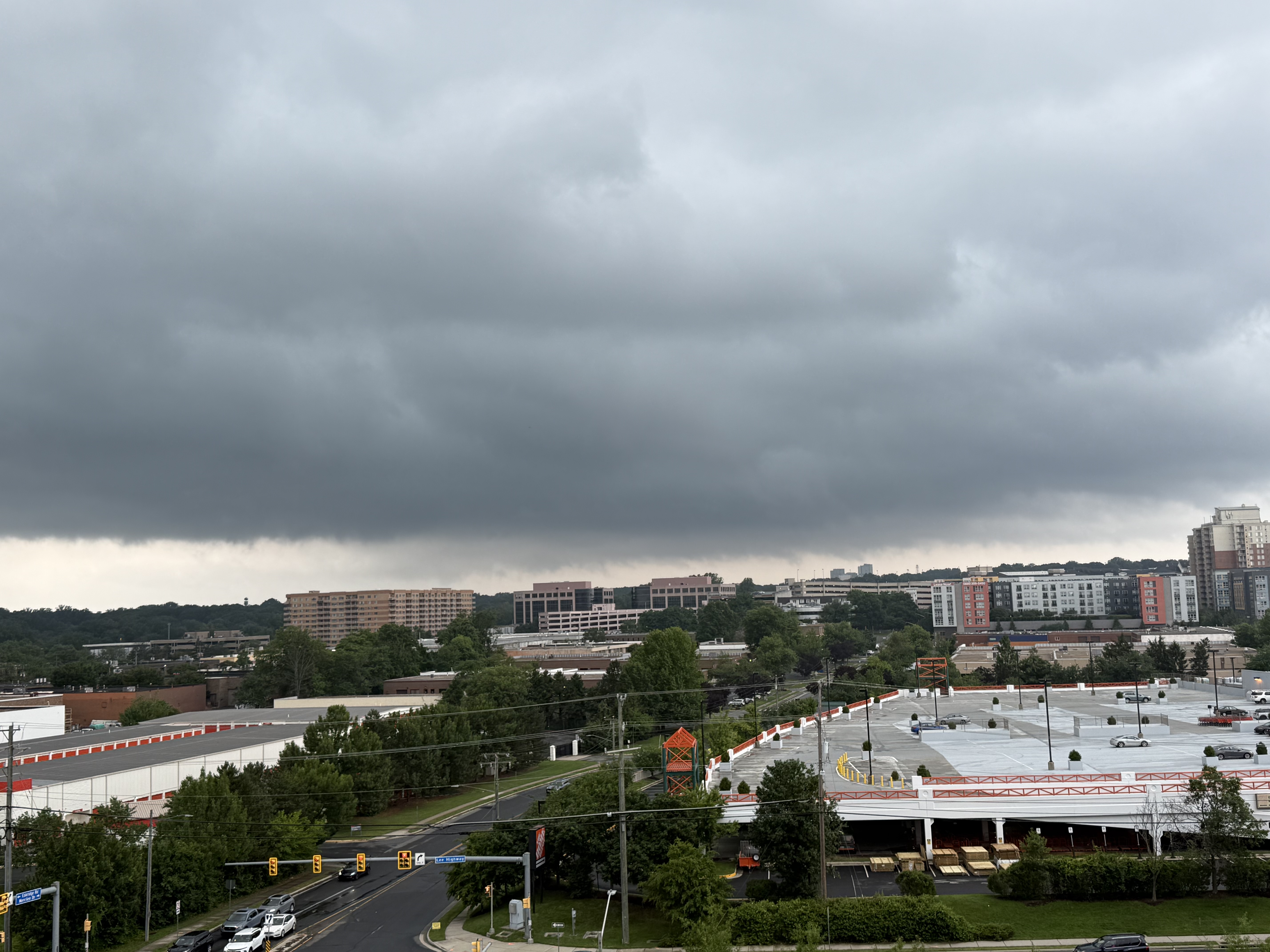
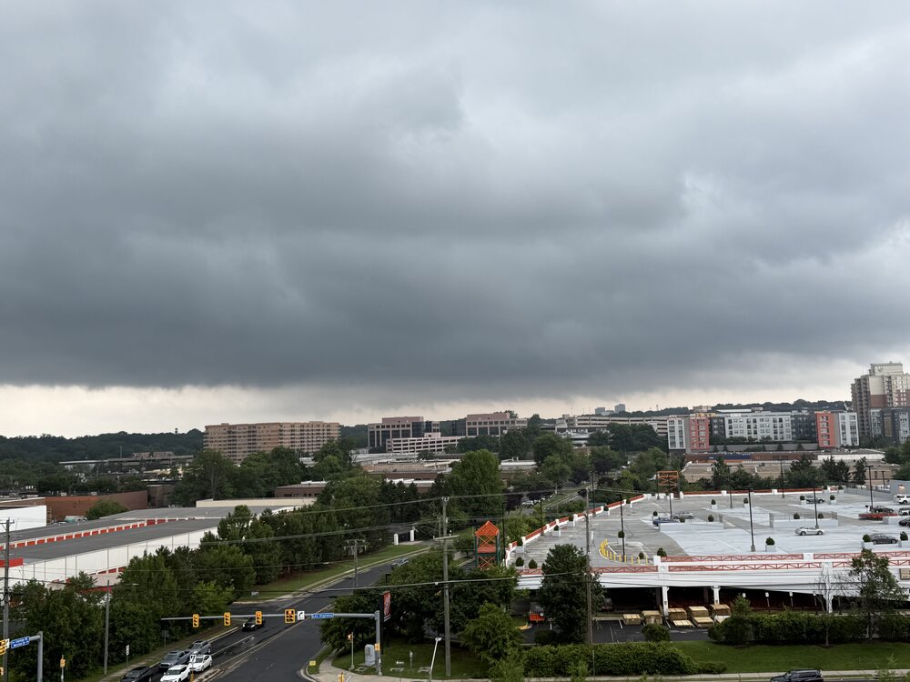
Was out running errands and thought that I’d see if that cell sliding by Tysons would deliver. Never tightened up. Pic from Mosaic overlooking the picturesque Merrifield Home Depot.
- 969 replies
-
- 3
-

-
- severe
- thunderstorms
- (and 2 more)
-
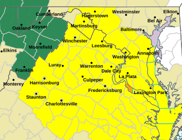
NWS Tornado watch until 10pm
-
Starting to get some sun here in the lowlands. It's definitely feeling warmer in the past 20 minutes. Hopefully there's a few wedges later.
-
TORNADO WATCH OUTLINE UPDATE FOR WT 392 NWS STORM PREDICTION CENTER NORMAN OK 225 PM EDT SUN JUN 8 2025 TORNADO WATCH 392 IS IN EFFECT UNTIL 1000 PM EDT FOR THE FOLLOWING LOCATIONS DCC001-090200- /O.NEW.KWNS.TO.A.0392.250608T1825Z-250609T0200Z/ DC . DISTRICT OF COLUMBIA COUNTIES INCLUDED ARE DISTRICT OF COLUMBIA $$ TORNADO WATCH OUTLINE UPDATE FOR WT 392 NWS STORM PREDICTION CENTER NORMAN OK 225 PM EDT SUN JUN 8 2025 TORNADO WATCH 392 IS IN EFFECT UNTIL 1000 PM EDT FOR THE FOLLOWING LOCATIONS MDC003-009-017-021-027-031-033-037-043-090200- /O.NEW.KWNS.TO.A.0392.250608T1825Z-250609T0200Z/ MD . MARYLAND COUNTIES INCLUDED ARE ANNE ARUNDEL CALVERT CHARLES FREDERICK HOWARD MONTGOMERY PRINCE GEORGES ST. MARYS WASHINGTON $$ TORNADO WATCH OUTLINE UPDATE FOR WT 392 NWS STORM PREDICTION CENTER NORMAN OK 225 PM EDT SUN JUN 8 2025 TORNADO WATCH 392 IS IN EFFECT UNTIL 1000 PM EDT FOR THE FOLLOWING LOCATIONS VAC003-013-015-029-033-036-041-043-047-049-057-059-061-065-069- 073-075-079-085-087-095-097-099-101-103-107-109-113-115-119-125- 127-133-137-139-145-153-157-159-165-171-177-179-187-193-199-510- 540-600-610-630-650-660-683-685-700-735-760-790-820-830-840- 090200- /O.NEW.KWNS.TO.A.0392.250608T1825Z-250609T0200Z/ VA . VIRGINIA COUNTIES INCLUDED ARE ALBEMARLE ARLINGTON AUGUSTA BUCKINGHAM CAROLINE CHARLES CITY CHESTERFIELD CLARKE CULPEPER CUMBERLAND ESSEX FAIRFAX FAUQUIER FLUVANNA FREDERICK GLOUCESTER GOOCHLAND GREENE HANOVER HENRICO JAMES CITY KING AND QUEEN KING GEORGE KING WILLIAM LANCASTER LOUDOUN LOUISA MADISON MATHEWS MIDDLESEX NELSON NEW KENT NORTHUMBERLAND ORANGE PAGE POWHATAN PRINCE WILLIAM RAPPAHANNOCK RICHMOND ROCKINGHAM SHENANDOAH SPOTSYLVANIA STAFFORD WARREN WESTMORELAND YORK VIRGINIA INDEPENDENT CITIES INCLUDED ARE ALEXANDRIA CHARLOTTESVILLE FAIRFAX FALLS CHURCH FREDERICKSBURG HAMPTON HARRISONBURG MANASSAS MANASSAS PARK NEWPORT NEWS POQUOSON RICHMOND STAUNTON WAYNESBORO WILLIAMSBURG WINCHESTER $$ TORNADO WATCH OUTLINE UPDATE FOR WT 392 NWS STORM PREDICTION CENTER NORMAN OK 225 PM EDT SUN JUN 8 2025 TORNADO WATCH 392 IS IN EFFECT UNTIL 1000 PM EDT FOR THE FOLLOWING LOCATIONS WVC003-037-090200- /O.NEW.KWNS.TO.A.0392.250608T1825Z-250609T0200Z/ WV . WEST VIRGINIA COUNTIES INCLUDED ARE BERKELEY JEFFERSON $$
- 969 replies
-
- 1
-
-
- severe
- thunderstorms
- (and 2 more)
-
Tornado watch up
-
Always La Plata
- 969 replies
-
- 1
-
-
- severe
- thunderstorms
- (and 2 more)
-
Was hoping the warm front would push a little further north, but seems like it's hit a wall. Not expecting much up here with the current temps and cloud cover except periods of showers.
-
90% plus cloud cover in the bronx.
- Today
-
Yeah that's cool visiting in winter like I said. Idk about doing the parks in July. That sounds rough...I haven't been to the parks since I was kid in the early 2000s. Nice, looking forward to more comfortable weather when I get home Tuesday.
-
Well so far the month of June has kept the trend going. Wet at times & no temps in the middle to high 90’s. The next 2 weeks look to be the same. Let’s hope this is the summer pattern for quite some time. The longer the heat dome is pushed back the shorter time we have to deal with it.
-
I can’t imagine living there and not being near the water. Strong hell no to interior Florida.
-

-
Interior FL is a hellhole. Gulf Coast Tampa-south is amazing. You need some air movement with the continuous 75-80+ dews and mins.