All Activity
- Past hour
-

September 2025 OBS-Discussion centered NYC subforum
winterwarlock replied to wdrag's topic in New York City Metro
Eventually I got it but not the initial one Hail windswept rain and some limbs down...about an inch with that one storm...closing in on 3 inches for past 4 days -

2025-2026 Fall/Winter Mountain Thread
Buckethead replied to Buckethead's topic in Southeastern States
Cloudy and 46° in Wolf this morning. Perfect hiking weather! Sent from my SM-S908U using Tapatalk -
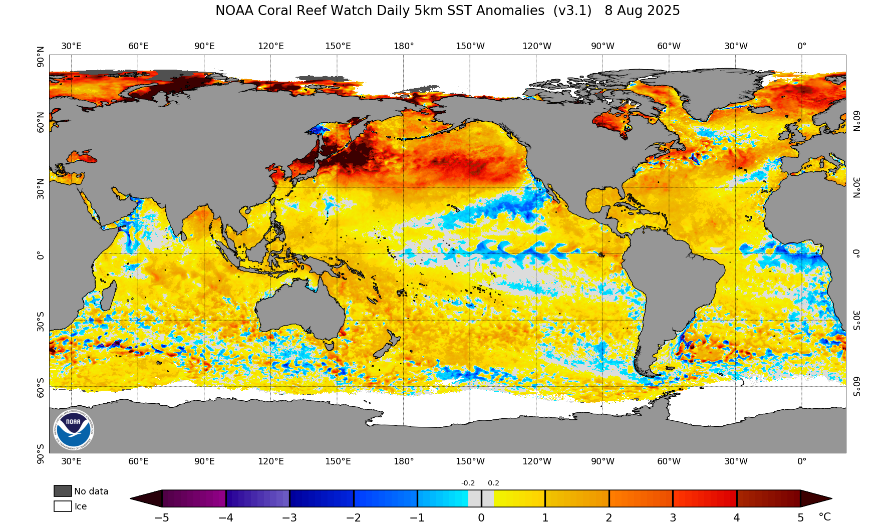
1 month trend in the PDO region is actually not bad... Early August Current EPS/GEFS/GEPS all show a bias towards upper level troughing near Japan over the next 2 weeks. Still way early and a long ways to go but with Nina enso conditions seeming likely this winter, a bathwater PDO region would be very problematic during met winter. If (and it's a big if) the -PDO collapses over the next 2 months, it would be a pretty big positive sign that winter could be interesting instead of soul crushing. Other than major blocking, which can't really be predicted until it's happening, there isn't much to get excited about irt a cold/snowy winter. Just pointing out something worth watching as we move through the next couple months.

-
The game itself should be mostly dry, but yeah, sucks right now
-
1.31” for the event
-
I forgot to empty my rain bucket from the 3" storm a couple weeks ago. Between yesterday's multiple storm hits and heavy rain all night. I'd estimate nearly 2". No drought in the lowlands lol
-
Orpheum in Boston.
-

September 2025 OBS-Discussion centered NYC subforum
PhiEaglesfan712 replied to wdrag's topic in New York City Metro
Barring a 10/2/2019 event, this should be all she wrote for the summer weather until next season. -
-
You just don’t get it and are unable to follow along are you ?
-
Pretty meh overall here yesterday, 0.85" with a weak cell, Stronger ones were north and south of here.
-
0.36" overnight and still dzl. So over 0.5 for both days (so far)
-
Garage sale fail. Closed up shop already. 1 person stopped since 8am. Good to get the much needed rain though. Anti-Stein.
-
Wow. Is the black line 2021?
-
E PA/NJ/DE Autumn 2025 Obs/Discussion
PhiEaglesfan712 replied to PhiEaglesfan712's topic in Philadelphia Region
Drought guy wrong again. I've been drought free since March 5. -
Hibbing was at 29 yesterday morning for a 1st place tie with 2018. 30 this morning. Back to more seasonable wx this week. Saw this in the records from Grand Forks. RECORD EVENT REPORTNATIONAL WEATHER SERVICE GRAND FORKS300 AM CDT FRI SEP 5 2025...RECORD LOW MAXIMUM TEMPERATURE SET AT THE GRAND FORKS UNIVERSITY/NWS CLIMATE STATION FOR THURSDAY SEPT 4TH...THE HIGH TEMPERATURE ON THURSDAY SEPTEMBER 4TH AT THE NATIONAL WEATHER SERVICE IN GRAND FORKS WAS 48 DEGREES. THIS SETS A RECORD FOR THE COLDEST HIGH TEMPERATURE RECORDED FOR THIS DATE. PREVIOUS RECORD LOW MAXIMUM TEMPERATURE WAS 55 IN 1956. LOOKING AT RECORD DATA BASE FOR THE CITY OF GRAND FORKS (1893 TO PRESENT), THIS IS ALSO THE EARLIEST DATE WHEN THE HIGH TEMPERATURE WAS BELOW 50 DEGREES WHEN LOOKING AT THE FALL MONTHS OF SEPTEMBER AND OCTOBER. THE PREVIOUS EARLIEST HIGH TEMPERATURE BELOW 50 DEGREES WAS SEPTEMBER 12 1961 WHEN THE HIGH TEMPERATURE WAS 49. THE RECORD DATABASE SHOWS THE AVERAGE DATE OF THE FIRST BELOW 50 DEGREE HIGH IN THE FALL IS OCTOBER 3RD. THIS IS USING THE RECORD DATABASE FROM 1893 TO CURRENT.
-

2025 Atlantic Hurricane Season
BarryStantonGBP replied to BarryStantonGBP's topic in Tropical Headquarters
Joe Bastard said there are similarities with this year and last year with the mjo placements only difference was that last year had lower amplitude so anyone screeching season cancel should sod off -
Where? I’d love to see them.
-
About 0.4" now for the last 24 hours. 0.55-0.6" for September. Not bad, but nothing at all on the horizon for the next 10-15 days except pleasant fall weather.
- Today
-

September 2025 OBS-Discussion centered NYC subforum
weathermedic replied to wdrag's topic in New York City Metro
1.39 so far at my station -
Nailed it.
-
Done here. 58.0° 0.24” between yesterday and today. 0.98” Aug-Sep total with little on the horizon. The next 2 weeks look Steined.
-
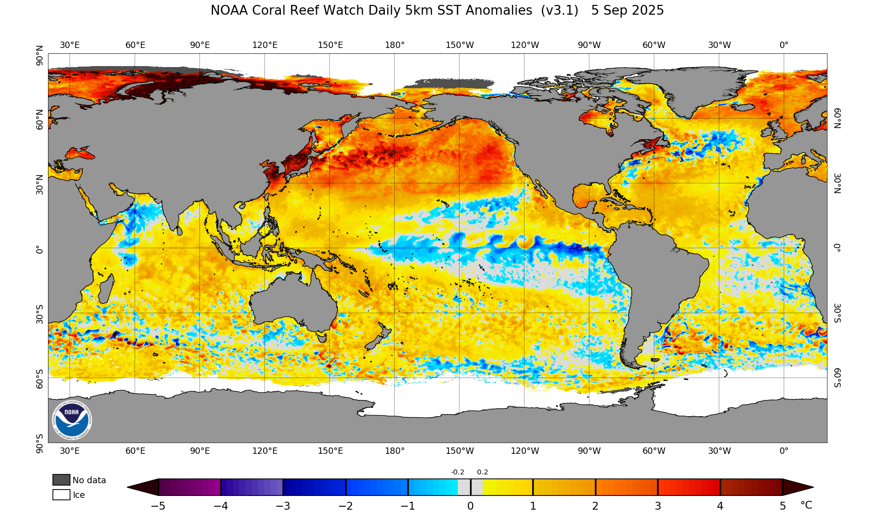
@Bluewave Once again, tropical forcing staying in the IO and the Maritime Continent regions…..
-

September 2025 OBS-Discussion centered NYC subforum
psv88 replied to wdrag's topic in New York City Metro
2.15”, based on radar 3” isn’t out of the question. Major short term bust -
Just over an inch since yesterday, which is more than I got in August