All Activity
- Past hour
-
14 days here of 90 plus.
-
flood watches up for most of NJ and SE PA
-

2026 C and E Pacific tropical activity
Wannabehippie replied to GaWx's topic in Tropical Headquarters
Will Lala make the rare crossing of the international date line, and get a new name? -
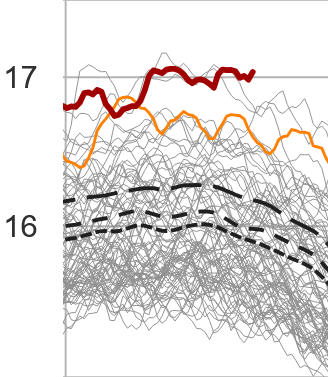
The August global t mean appears to be moving the wrong direction ...
-
To 90 28th of the season here
-

Augdewst 2026: Summer's Last Stand
Typhoon Tip replied to Prismshine Productions's topic in New England
LOL, tru ...guess I was thinking along the dopey lines of losing winters for 85/60 chamber of commies. -
I'm not at 40N, but with being at 39.92N, I've experienced 1 AN snowfall here since 2019. 20/21 was it. 21/22 BWI beat me as I totally missed the 1/22 event. Basically, the Niñas, save 1, have been better to my E and NE, while the 23/24 Niño sucked for all.
-

Augdewst 2026: Summer's Last Stand
dendrite replied to Prismshine Productions's topic in New England
No thanks...we'd have an ice cap while tanning. -

2026-2027 Record-breaking El Nino
forkyfork replied to Stormchaserchuck1's topic in Weather Forecasting and Discussion
Curry added, "This prediction is in contrast to the recently released IPCC AR5 Report that projects an imminent resumption of the warming, likely to be in the range of a 0.3 to 0.7 degree Celsius rise in global mean surface temperature from 2016 to 2035." the ipcc wound up being too conservative. lol -

Central PA Summer 2026 Discussion/Obs Thread
Jns2183 replied to Voyager's topic in Upstate New York/Pennsylvania
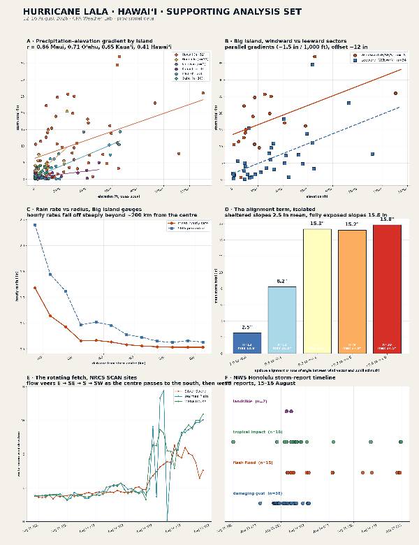
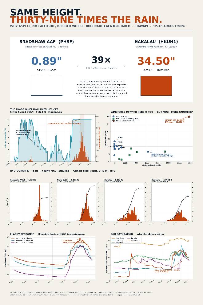
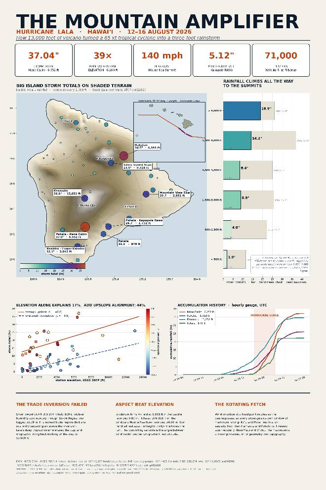
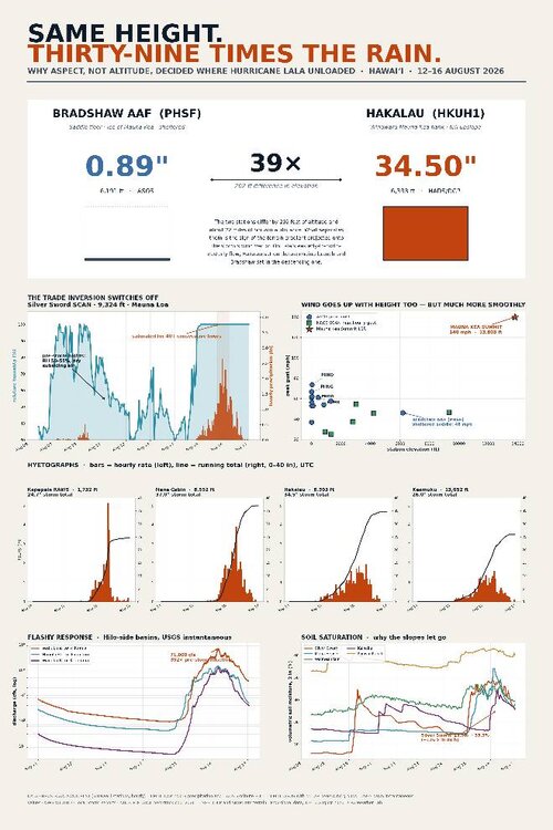
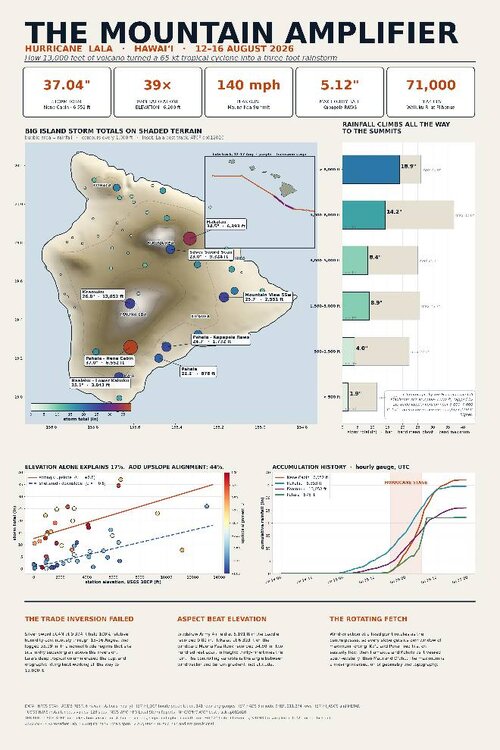
I love Hawaii for being at the same time a hydrologist nightmare and heaven. the duality of existence in 3 infographs Sent from my SM-S731U using Tapatalk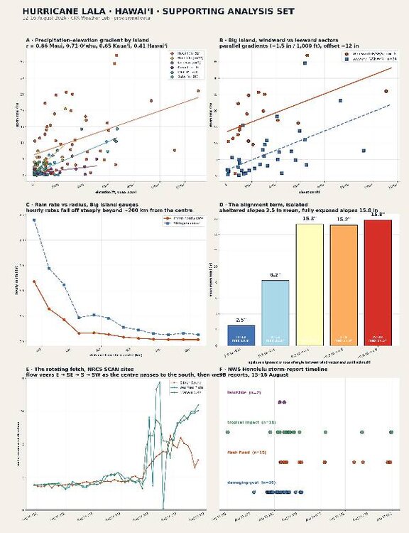
-

2026-2027 Record-breaking El Nino
LakePaste25 replied to Stormchaserchuck1's topic in Weather Forecasting and Discussion
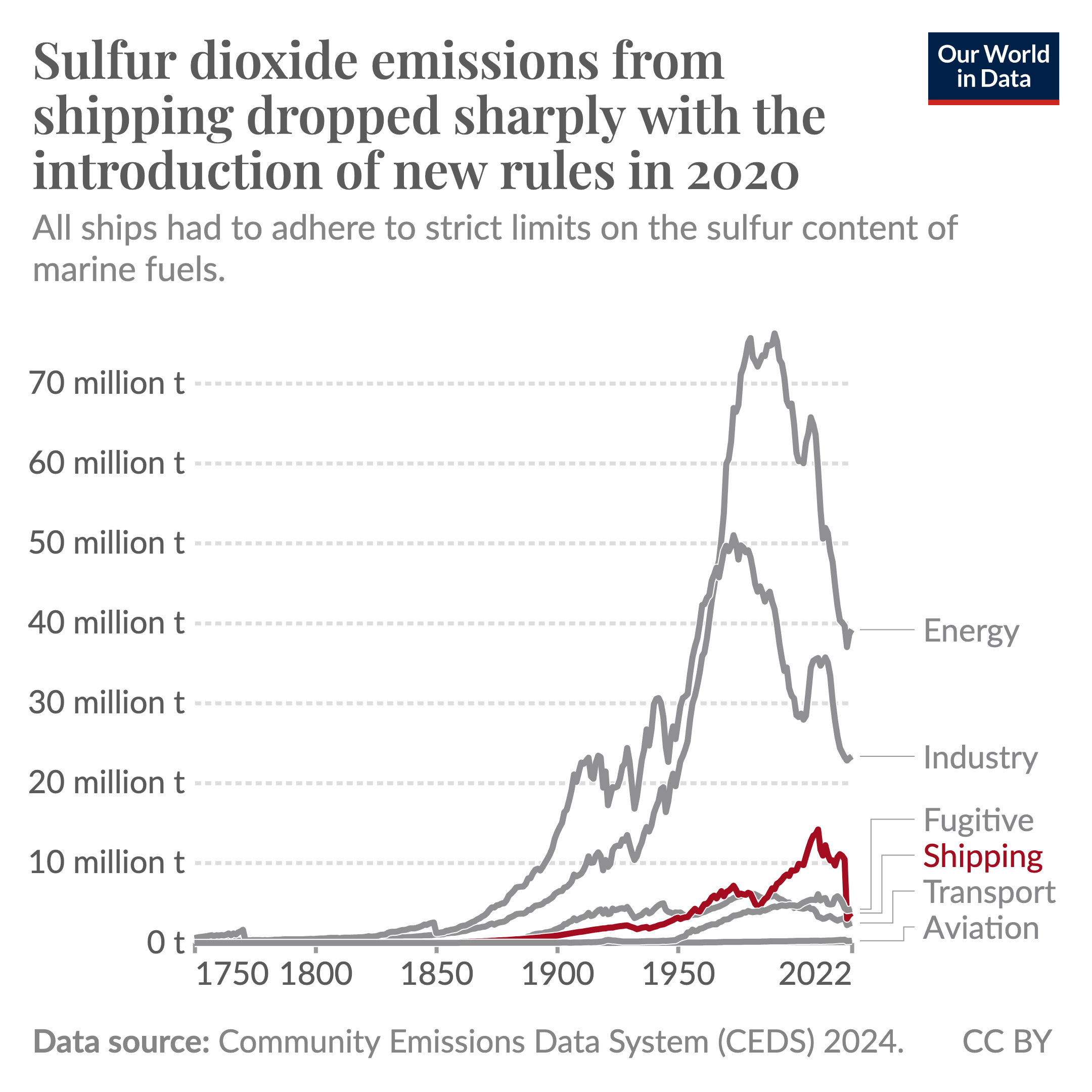
yeah mid 20th century lull came from sulfur which blocks solar radiation.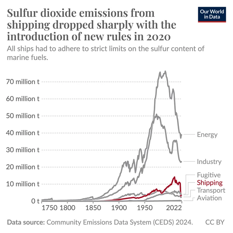
-
.thumb.png.3513c28619bf91f0fa8e4004956c33df.png)
2026-2027 Record-breaking El Nino
annunciated replied to Stormchaserchuck1's topic in Weather Forecasting and Discussion
It appears a very small area of +11C has been detected in the ENSO subsurfaces. Jesus.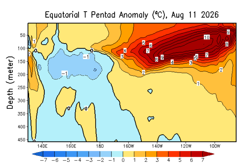
-
Augdewst 2026: Summer's Last Stand
Typhoon Tip replied to Prismshine Productions's topic in New England
Heh... too bad we couldn't move the snow temperature from 32 to 52, huh -
Central PA Summer 2026 Discussion/Obs Thread
Jns2183 replied to Voyager's topic in Upstate New York/Pennsylvania
did you see some of the rain totals?? I downloaded a bunch of the networks and saw many 20" to 40" totals. Multiple hours of 2"-5" per hour rates. what's nuts is unless those gauges are weighing gauges, which only a few are, those totals are definite underestimates due to the nature of tipping bucket rain gauges when you have heavy rain and wind Sent from my SM-S731U using Tapatalk -
2026-2027 Record-breaking El Nino
forkyfork replied to Stormchaserchuck1's topic in Weather Forecasting and Discussion
price is right losing horn -
2026-2027 Record-breaking El Nino
forkyfork replied to Stormchaserchuck1's topic in Weather Forecasting and Discussion
https://sustainability.gatech.edu/hg/news/2013/10/10/stadium-waves-could-explain-lull-global-warming “The stadium wave signal predicts that the current pause in global warming could extend into the 2030s," said Wyatt, an independent scientist after having earned her Ph.D. from the University of Colorado in 2012.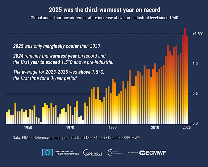
-
Augdewst 2026: Summer's Last Stand
Typhoon Tip replied to Prismshine Productions's topic in New England
I bet 72/52 may even feel a bit chilly to some after recent acclimation biasing - -
 North Trust Pharmacy: North Trust Pharmacy - canadian pharmacy sarasota
 -
I bet tomorrow will be yet another almost 100% cloudy, ridiculously muggy day.
-
Well here in SC, we been knocking on the door of 100 deg or higher for quite some time. 90 would feel pretty good right now. Yes, I am stunned I wrote that, and mildly sad.
-
Augdewst 2026: Summer's Last Stand
dendrite replied to Prismshine Productions's topic in New England
I think today is beautiful, but this is COC now?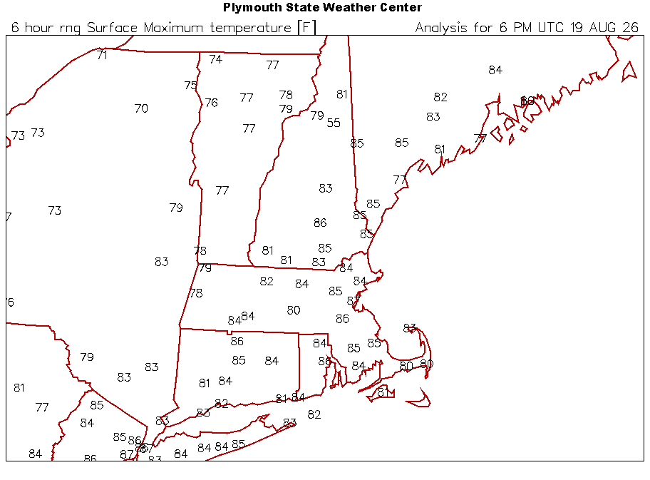
-
2026-2027 Record-breaking El Nino
forkyfork replied to Stormchaserchuck1's topic in Weather Forecasting and Discussion
the hypothesis that your username is based on fell apart 10 years ago -
(002).thumb.png.6e3d9d46bca5fe41aab7a74871dd8af8.png) Thanks! Mike, that is really the crux of the discussion and I think we've arrived at the same place. "The magnitude of the adjustment is inferred, but not well documented in the sense that it has been verified by field measurements" - that is precisely the claim I've been making, and I appreciate you putting it plainly rather than trying to make me prove it. And thank you for the two references. Parallel observation is the gold standard and I hadn't seen either paper. Vincent 2018 is the one I want most - 88 site pairs with five-year overlaps quantifying how much uncertainty homogenisation introduces against directly measured ground truth is exactly the number missing from this discussion. If the answer is small, that's a real argument for confidence in the method that isn't an appeal to benchmarks on synthetic networks. If it's large, that's worth knowing too. Either way it's measured rather than modelled.
Thanks! Mike, that is really the crux of the discussion and I think we've arrived at the same place. "The magnitude of the adjustment is inferred, but not well documented in the sense that it has been verified by field measurements" - that is precisely the claim I've been making, and I appreciate you putting it plainly rather than trying to make me prove it. And thank you for the two references. Parallel observation is the gold standard and I hadn't seen either paper. Vincent 2018 is the one I want most - 88 site pairs with five-year overlaps quantifying how much uncertainty homogenisation introduces against directly measured ground truth is exactly the number missing from this discussion. If the answer is small, that's a real argument for confidence in the method that isn't an appeal to benchmarks on synthetic networks. If it's large, that's worth knowing too. Either way it's measured rather than modelled. -
Another Flood Watch, been the summer of flood watches and brown patch. I bet they expand the Flood Watch SW later today. Flood Watch National Weather Service Mount Holly NJ Issued by National Weather Service New York NY 208 PM EDT Wed Aug 19 2026 DEZ001-NJZ009-010-012>022-025>027-PAZ070-071-101>106-200900- /O.NEW.KPHI.FA.A.0008.260820T1600Z-260821T0600Z/ /00000.0.ER.000000T0000Z.000000T0000Z.000000T0000Z.OO/ New Castle-Hunterdon-Somerset-Middlesex-Western Monmouth-Eastern Monmouth-Mercer-Salem-Gloucester-Camden-Northwestern Burlington- Ocean-Cumberland-Atlantic-Coastal Atlantic-Coastal Ocean- Southeastern Burlington-Delaware-Philadelphia-Western Chester- Eastern Chester-Western Montgomery-Eastern Montgomery-Upper Bucks- Lower Bucks- Including the cities of Camden, Flemington, Oxford, West Chester, Pennsville, Trenton, Perkasie, Wilmington, Collegeville, Doylestown, Lansdale, New Brunswick, Kennett Square, Media, Sandy Hook, Chalfont, Atlantic City, Pottstown, Philadelphia, Norristown, Morrisville, Wharton State Forest, Cherry Hill, Hammonton, Honey Brook, Moorestown, Long Beach Island, Somerville, Mount Holly, Jackson, Millville, Glassboro, and Freehold 208 PM EDT Wed Aug 19 2026 ...FLOOD WATCH IN EFFECT FROM THURSDAY AFTERNOON THROUGH LATE THURSDAY NIGHT... * WHAT...Flash flooding caused by excessive rainfall is possible. * WHERE...Portions of northern Delaware, including the following area, New Castle, New Jersey, including the following areas, Atlantic, Camden, Coastal Atlantic, Coastal Ocean, Cumberland, Eastern Monmouth, Gloucester, Hunterdon, Mercer, Middlesex, Northwestern Burlington, Ocean, Salem, Somerset, Southeastern Burlington and Western Monmouth, and southeast Pennsylvania, including the following areas, Delaware, Eastern Chester, Eastern Montgomery, Lower Bucks, Philadelphia, Upper Bucks, Western Chester and Western Montgomery. * WHEN...From Thursday afternoon through late Thursday night. * IMPACTS...Excessive runoff may result in flooding of rivers, creeks, streams, and other low-lying and flood-prone locations. Creeks and streams may rise out of their banks. Flooding may occur in poor drainage and urban areas. * ADDITIONAL DETAILS... - Multiple rounds of showers and thunderstorms are expected across the area beginning Thursday afternoon through Thursday evening. Rainfall rates of 1 to 3 inches per hour are possible. Rainfall amounts of 1 to 2 inches are possible with localized amounts of 3 to 5 inches which could cause flash flooding. - http://www.weather.gov/safety/flood PRECAUTIONARY/PREPAREDNESS ACTIONS... You should monitor later forecasts and be prepared to take action should Flash Flood Warnings be issued. && $$ DeSilva
-

Augdewst 2026: Summer's Last Stand
Damage In Tolland replied to Prismshine Productions's topic in New England
When did the poster move there? Always lived in Burlington