All Activity
- Past hour
-
Your $500,500.99 Gift Is Hiding on This Page https://telegra.ph/Get-a-gift-worth-up-to-50050099---886455-01-22 Profile ID: s1fg8m6x0v1j6b2zw6ov8m0h6v5j5l6mg0bl1y6q5a9h6m6me9qg0g0u9r3z4g9gx7zn3d2a4h2n8s3tn1xa2x7c8d6e4u4ip4ak4p3r6p0o6h0u
-
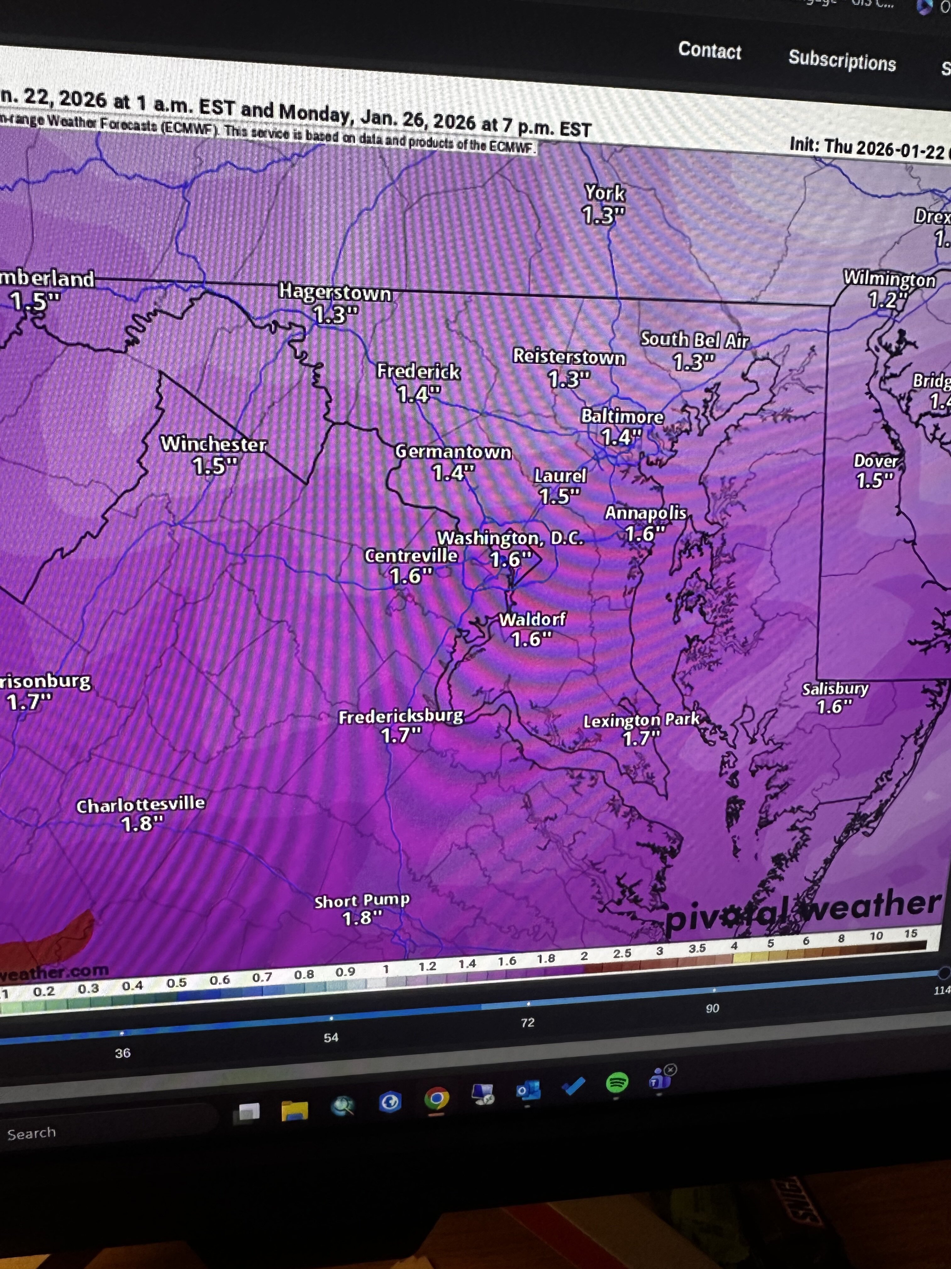
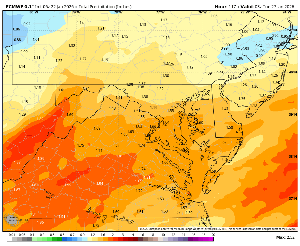
Zoomed in qpf
-

January 24-26: Miracle or Mirage JV/Banter Thread!
WxUSAF replied to SnowenOutThere's topic in Mid Atlantic
I’m mostly curious what info the normies are getting. Family friend that visited last night was lamenting the rapid Apple weather app snow total changes… -

Site is unusable on mobile because of ads
WthrJunkyME replied to Nash_LSU's topic in Forum Information & Help
A $500,500.99 Gift to Break the Ice https://telegra.ph/Get-a-gift-worth-up-to-50050099---838219-01-21 Value: w1jb2u0l3t8m4v8nb7pu7f9c2h3c7b6fs3ly4f6z7h8g9z4nu6eo4u2k6d7l7x4bz4cn1n9f0q5t7j8pd4gm8s8a3x3d1h4lm6ew7j8r1t9b4c8j -
Euro looks a few degrees warmer at the surface than other models.
-

Central PA Winter 25/26 Discussion and Obs
pasnownut replied to MAG5035's topic in Upstate New York/Pennsylvania
with GFS Ukie, and Euro looking good to really good, that's a nice way to start the day. Surely not wise to discount Icon and CMC, but regardless it looks like taint is possible but shouldnt be a major factor north of M/D line. Hope that trend holds today. -
Pretty wild the warm nose makes it to your neck of the woods. From what I remember you’re northernmost portion of the forum.
-

January 25/26 Jimbo Back Surgery Storm
NorthHillsWx replied to Jimbo!'s topic in Southeastern States
It’s crazy, yea it played in La La land too in the 5-7 day range but euro sniffed something out 4 days out, made that dramatic jump and here we are, everything has slowly worked into the euro camp. Once again, the GFS is just a terrible model. The Euro under 5 days is just a beacon of despair around here. If it’s bad, it ain’t going back the other way -

January 2026 regional war/obs/disco thread
mahk_webstah replied to Baroclinic Zone's topic in New England
You’re gonna have helluva pack -

“Cory’s in LA! Let’s MECS!” Jan. 24-26 Disco
moneypitmike replied to TheSnowman's topic in New England
Cut back up north. -
Getting that coastal more involved seems a trend this morning. If true not crazy to think someone pulling a two footer out of this
-

Possible Record Breaking Cold + Snow Sunday 1/25 - Tuesday 1/27
jm1220 replied to TriPol's topic in New York City Metro
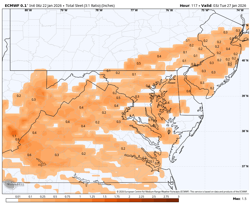
It’s really not overly complicated, if we have a strong 700/850 low go NW of us, we will mix eventually-plain and simple. That means the winds at those levels are from the south and a warm direction. It doesn’t matter that the surface is cold. We could have a lot of snow fall before then but the same mechanism driving all the moisture from the Gulf also brings warm air. If the snow comes in like a wall it helps hold the warm mid level air back and we can pile it up quickly, if it comes in like shredded garbage it will disappoint and we get sleet sooner. We could also dry slot before or as that warm air arrives since dry air will pivot around the mid level lows from the south. We need the mid level confluence to force a further south transfer. If se see that retreating we have a typical SWFE setup. There’s the other possibility of a coastal system bringing snow back in but I think that won’t be determined until we’re closer in. -
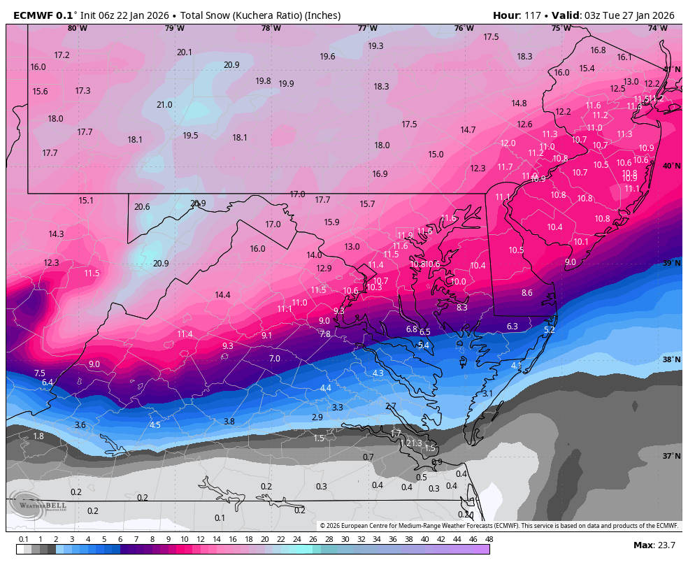
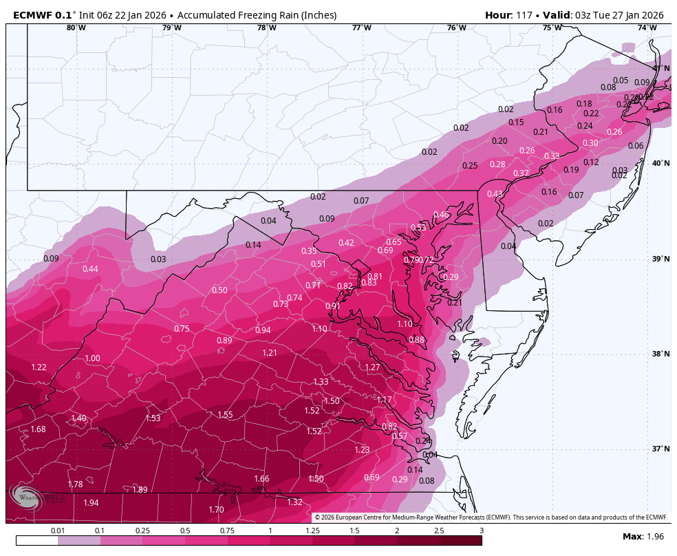
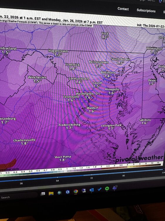
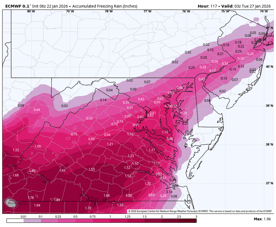
Totals WB 6Z EURO


-

Pittsburgh/Western PA WINTER ‘25/‘26
colonel717 replied to Burghblizz's topic in Upstate New York/Pennsylvania
We are at 12-13 inches with all this to the west for the NAM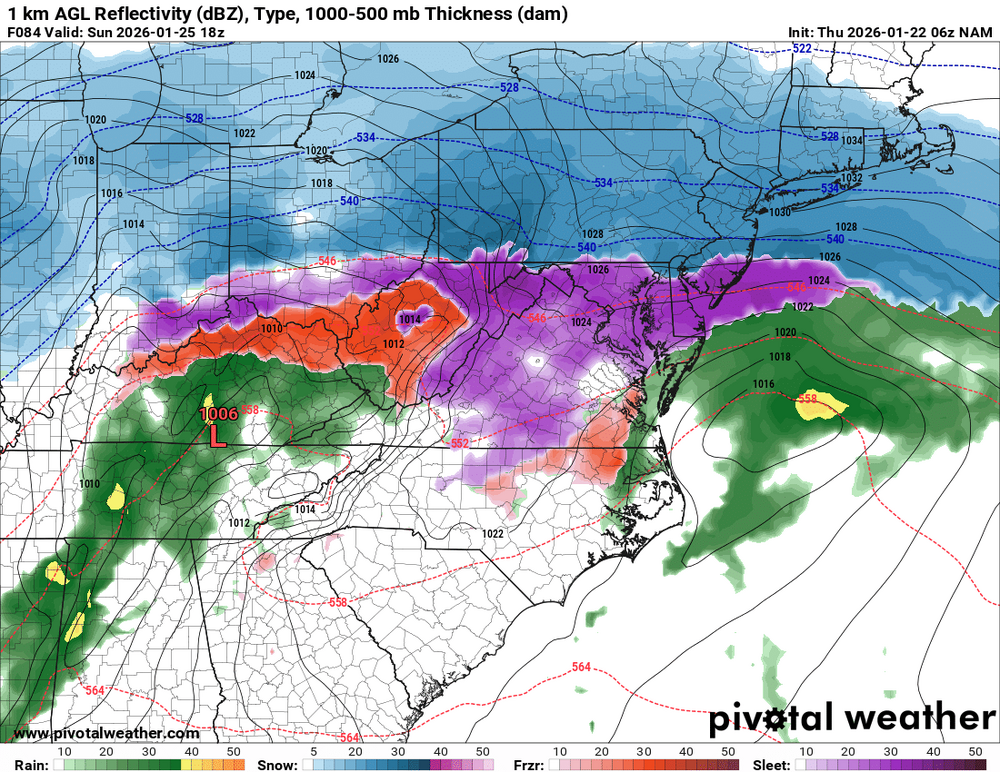
-
I’m terrible at analysis but it’s a region wide hold, def sleety in the afternoon Sunday for 95 east
-
WV panhandle looks to be the spot on the euro...im holding on for dear life at 4pm
-
4” of fluff total .
-

Central PA Winter 25/26 Discussion and Obs
Blizzard of 93 replied to MAG5035's topic in Upstate New York/Pennsylvania
I’m he ICON is the worst model, so not worried whatever it shows. Euro & GFS & Euro AI along with their ensembles all show us getting buried. If the southern tier mixes at the end, it would likely be after a foot is on the ground. -
Reeks of a CF. Soundings to pinpoint ratios. Start at a good foot att adjust accordingly.
-
About an inch qpf IMBY before any flip
-
Euro still has that warm nose at 700-850 gets up to me by Sunday afternoon
-
“Cory’s in LA! Let’s MECS!” Jan. 24-26 Disco
mahk_webstah replied to TheSnowman's topic in New England
And that’s 10:1 so add at least 20% and maybe up to 50% -
Hey Grandpa.
-

Pittsburgh/Western PA WINTER ‘25/‘26
southpark replied to Burghblizz's topic in Upstate New York/Pennsylvania
What a turnaround on the GFS. Wish the storm was starting right now with that run! -
Being honest, without any caffeine in me, to me the 6Z GFS looks very, very similar to the EURO solution. The only difference is the GFS holds the HP in place stronger and longer than the EURO does keeping the CAD in place. We don't want that mess the GFS is offering. Since most are out of the snow game at this point, I'd just soon have T-storm warnings.