


Random Chaos
-
Posts
908 -
Joined
-
Last visited
About Random Chaos

Recent Profile Visitors






-

2026 Mid-Atlantic Severe Storm General Discussion
Random Chaos replied to Kmlwx's topic in Mid Atlantic
890 NOUS41 KLWX 302258 PNSLWX DCZ001-MDZ003>006-008-011-013-014-016>018-501>510-VAZ025>031- 036>040-050-051-053>057-501>508-526-527-WVZ050>053-055-501>506- 311100- Public Information Statement National Weather Service Baltimore MD/Washington DC 658 PM EDT Thu Jul 30 2026 ...NWS Damage Survey for 07/28/26 Tornado Event... .Overview...A line of severe thunderstorms ahead of a cold front moved through the area during the evening of Tuesday, July 28th, 2026. Changing wind speed and direction with height, enhanced by a localized bay breeze along the Chesapeake Bay`s Western Shore, caused the storms to rotate, which resulted in at least three tornadoes in Anne Arundel County, Maryland. As additional information is received and reviewed, additional surveys or statements may be issued in the next few days. .Tornado #1: Riviera Beach Tornado... Rating: EF-0 Estimated Peak Wind: 85 mph Path Length /statute/: 1.1 miles Path Width /maximum/: 90 yards Fatalities: 0 Injuries: 0 Start Date: Jul 28, 2026 Start Time: 6:04 PM EDT Start Location: Riviera Beach / Anne Arundel County / MD Start Lat/Lon: 39.1736 / -76.5256 End Date: Jul 28, 2026 End Time: 6:08 PM EDT End Location: Sunset Beach / Anne Arundel County / MD End Lat/Lon: 39.1584 / -76.5225 Survey Summary: What likely began as a waterspout moving toward the south- southwest over the tidal Patapsco River moved onshore along Cox Creek in the Riviera Beach area of northeastern Anne Arundel County. A grill was flipped and numerous trees were snapped near the top, falling in a convergent manner near the intersection of Waterview Drive and Riverside Drive. The tornado continued toward the south, where a street sign was bent and large sections of siding were removed from a house near the intersection of Waterview Drive and Hilltop Road; numerous trees were downed in a convergent manner on this block, as well. Large tree limbs and tree tops were snapped near the intersection of West End Drive and Park Place, with additional large limbs twisted off and tops of trees sheared off near the intersection of West End Drive and Fieldstone Place. The tornado then crossed Stoney Creek near the bridge on MD-173 Fort Smallwood Road, before felling additional trees and a power pole prior to dissipating in the Sunset Beach area. The National Weather Service thanks trained spotters, media, and local emergency officials for their assistance in this survey. .Tornado #2: Lake Shore Tornado... Rating: EF-1 Estimated Peak Wind: 100 mph Path Length /statute/: 0.7 miles Path Width /maximum/: 200 yards Fatalities: 0 Injuries: 0 Start Date: Jul 28, 2026 Start Time: 6:15 PM EDT Start Location: Grays Creek / Anne Arundel County / MD Start Lat/Lon: 39.0941 / -76.4699 End Date: Jul 28, 2026 End Time: 6:17 PM EDT End Location: Magothy River / Anne Arundel County / MD End Lat/Lon: 39.0848 / -76.4680 Survey Summary: A tornado descended around Patapsco Road where a few trees were uprooted and snapped. As the tornado tracked through New York Avenue and Magothy Road, the intensity of the wind increased with numerous trees uprooted along with a power pole and several tree trunks snapped. A boat was also lofted into the air, over a pier, and onto a jet ski. Damage was laying in different directions, indicative of rotation. A large tree also fell onto a house. Another home off Magothy Road had roof singles ripped off, along with a loss of some siding. The tornado tracked over Grays Creek and more trees were uprooted along Dobbins lane. Numerous trees were uprooted along Edgewater Road with damage facing different directions. A few tree trunks were snapped as well. The end of the damage path was observed just south of Edgewater Road along the Magothy River. A security camera here recorded the swirling winds passing through. The National Weather Service thanks the Anna Arundel County MD Office of Emergency Management for their assistance with this survey. .Tornado #3: Arnold/Cape Saint Claire Tornado... Rating: EF-1 Estimated Peak Wind: 100 mph Path Length /statute/: 0.5 miles Path Width /maximum/: 75 yards Fatalities: 0 Injuries: 0 Start Date: Jul 28, 2026 Start Time: 6:17 PM EDT Start Location: Arnold / Anne Arundel / MD Start Lat/Lon: 39.0546 / -76.4648 End Date: Jul 28, 2026 End Time: 6:19 PM EDT End Location: Cape Saint Claire / Anne Arundel / MD End Lat/Lon: 39.0564 / -76.4592 Survey Summary: A tornado touched down in a wooded area north of Shore Acres Road in the 900 block, with trees snapped at the top. The tornado tracked east crossing Lake Drive in Cape Saint Claire. Significant tree damage was observed in a convergent direction. Many healthy hardwood trees up to a few feet in diameter were toppled. On Lake Drive, and a garage door of a house was completely blown in, with some insulation removed. The National Weather Service thanks the Anna Arundel County MD Office of Emergency Management for their assistance with this survey. -
0.81” rain, 40mph peak wind. Definitely some tornadic circulation at ground level over the Chesapeake Bay near the Magothy River, but no funnel clouds.
-
2026 Mid-Atlantic Severe Storm General Discussion
Random Chaos replied to Kmlwx's topic in Mid Atlantic
My rain gauge is showing over 8in/hr rate right now. 0.62” so far.- 2,004 replies
-
- 2
-

-
- severe
- thunderstorms
- (and 7 more)
-
2026 Mid-Atlantic Severe Storm General Discussion
Random Chaos replied to Kmlwx's topic in Mid Atlantic
Definitely multiple sea surface rotational winds on the Chesapeake Bay near the mouth of the Magothy River about 5-10 minutes ago.- 2,004 replies
-
- 1
-
-
- severe
- thunderstorms
- (and 7 more)
-
Big Heat (and storms?) Week into July 4th Weekend
Random Chaos replied to yoda's topic in Mid Atlantic
0.32 on 7/4 0.69 on 7/5 0.00 overnight At least it’s something against my rain deficit. -
2026 Mid-Atlantic Severe Storm General Discussion
Random Chaos replied to Kmlwx's topic in Mid Atlantic
Saw two separate storm reports of 83mph winds just south of US50 through the Annapolis area. Looked like the main cell went just south of the 50 corridor from Parole to the Bay Bridge. I’m just north of that and didn’t get anything severe level, but lost power maybe 5 minutes ahead of the storm - based on outaged 2-3 substations on Broadneck probably all lost power, like a tree (or trees) down nesr the naval academy or along St Margaret’s Rd. Where the feed lines for the substations go. 0904 PM Marine Tstm Wind 7 ESE Cape St. Claire 38.99N 76.34W 06/12/2026 M83 mph ANZ532 MD Mesonet 0904 PM Tstm Wnd Gst 3 S Cape St. Claire 39.00N 76.45W 06/12/2026 M75 mph Anne Arundel MD Mesonet 0844 PM Tstm Wnd Gst 1 SE Parole 38.98N 76.54W 06/12/2026 M83 mph Anne Arundel MD Mesonet- 2,004 replies
-
- 2
-

-
-
- severe
- thunderstorms
- (and 7 more)
-
Feb 22nd/23rd "There's no way..." Obs Thread
Random Chaos replied to Maestrobjwa's topic in Mid Atlantic
35.2F, moderate to heavy snow, minimal sticking - mostly melting on contact. -
Feb 22nd/23rd "There's no way..." Obs Thread
Random Chaos replied to Maestrobjwa's topic in Mid Atlantic
36.7F here. That's already below what some models were calling for tomorrow at dawn. -
2/22-23 "There's no way..." Storm Part 2
Random Chaos replied to Maestrobjwa's topic in Mid Atlantic
Just took some temperature measurements with my IR thermometer. My measurements are for just NW of Sandy Point State Park. Soil surface temperature varied between 29.8F and 35.2 F with most readings in the 32 to 33F range. This was measured after the sun dipped below the horizon. Chesapeake Bay temperature measured 33.8F (this is near shore on the open bay, not up a river or creek). This is the same as what I measured last night. My weather station has air temperature at 45.9F I don't see temperature as a likely problem come morning near the Chesapeake Bay. As a note, there is still snowcrete from the last storm on a beach near the top of it. I also have scattered spots in my yard that still have snowcrete. -
2/22-23 "There's no way..." Storm Part 2
Random Chaos replied to Maestrobjwa's topic in Mid Atlantic
How? Chesapeake bay running 34F (I measured 33.8F yesterday) and we have a gale warning for winds off the water. Peak surface temperatures for Annapolis area will be held close to freezing from those winds. I don’t see temperatures near the water to be a problem. -
2/22-23 "There's no way..." Storm Part 2
Random Chaos replied to Maestrobjwa's topic in Mid Atlantic
Not everyone. Annapolis went from 18 ro 23” high end. -
2/22-23 "There's no way..." Storm Part 2
Random Chaos replied to Maestrobjwa's topic in Mid Atlantic
10:1 stuck a 27.9” over us on GFS -
2/22-23 "There's no way..." Storm Part 2
Random Chaos replied to Maestrobjwa's topic in Mid Atlantic
Just measured the bay temperature with an IR thermometer, 33.8F. Near shore so might be high given daytime solar heating on shallow water. Near bay bridge. -
2/22-23 "There's no way..." Storm Part 2
Random Chaos replied to Maestrobjwa's topic in Mid Atlantic
Bay is 34F right now. Not exactly warm. This is forecast for Sunday 7am: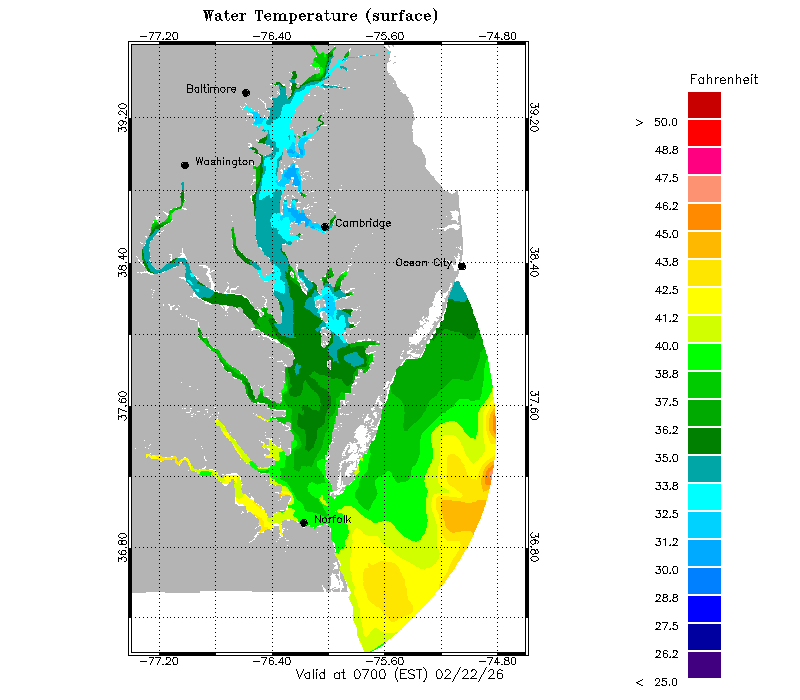
-
Feb 22nd/23rd "There's no way..." Storm Thread
Random Chaos replied to Maestrobjwa's topic in Mid Atlantic
What’s with the ptype on RGEM. Feels like the 540 line is too far south for it to be rain that far north on hr 69.