All Activity
- Past hour
-
Rain hitting the roof sounds good. Its been a little while.
-
Aaaannnnndddd there's lightning in Litchfield County CT...
-
 I still think it's too early to get a great sense for anything in the US. This is a really complicated steering pattern, in large part driven by the proximity of 93L and 94L. Folks along the coast should definitely pay attention to this one, though there's no real need for concern yet. The Euro trend toward a strong 94L is interesting though. That's definitely something to watch.
 -
If there is going to be a period of more widespread showers, it looks to be very early Thursday. Otherwise, there will be some big winners with the scattered convection each day (especially Thursday), but it doesn't look to be particularly widespread.
-
2025 Atlantic Hurricane Season
WxWatcher007 replied to BarryStantonGBP's topic in Tropical Headquarters
Maybe but what's a bust to you? -
Back at WXW1 and it's downright tropical
-
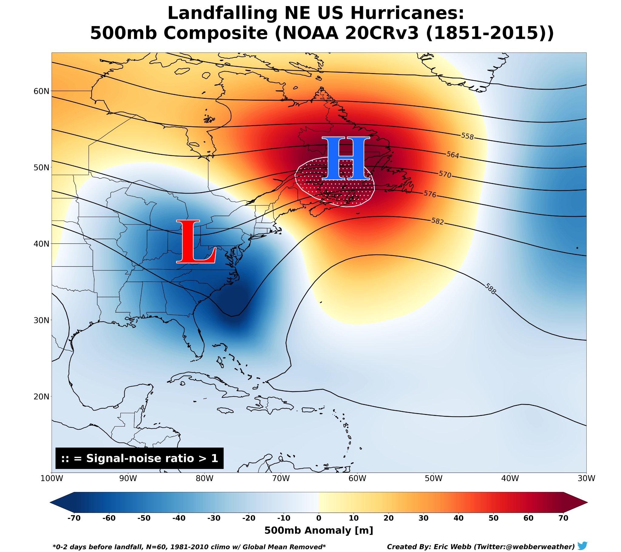
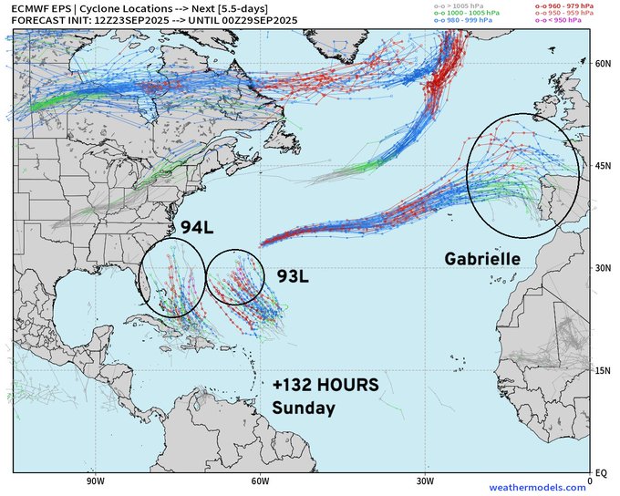
I mean, the first thing when discussing New England tropical is caveating it to death about how hard it is to get legit tropical up this way. Now that that's out of the way, if we're talking about strictly a NE landfall I agree with @FXWX, the overall setup does not lend itself to a Long Island Express scenario. Not even close. Here's what the general NE landfall steering pattern looks like: And here are the latest 500mb depictions of the EPS and GEFS for Monday at 12z: The GFS/GEFS originally led the way in highlighting the possibility of TC genesis, but has seemed to be way off with trying to consolidate 93L and 94L off the southeast coast. That has its own implications but just look at the 500h vs the usual NE setup. Yeah, there's a cutoff in the southeast, but the ridge is too far west and that opens an escape hatch to the east even if this landfalls further south. The EPS is a little more interesting to me but you can see the same issue. The cutoff and ridge over the top brings a potential US threat, but its further south, again because the ridge is too far west and that opens the escape hatch to the east. Here's 18z Euro operational: Even with a highly anomalous potential interaction off the SE coast with two hurricanes, you have the same issue, though the UL cutoff is still around and there is a strong Atlantic ridge (that would likely still lead to an escape hatch with that NW flow in SE Canada). What you'd need for a coastal runner imo is either 1) the ridge quickly translating east over SE Canada, thereby blocking the escape hatch or 2) a stronger and further north cutoff that can capture and pull whatever is out there into the coast (though even there you risk a close miss rather than a direct strike). This is very different further south, especially in the Carolinas if this is buried in the Bahamas and there's a cutoff to the west. So while this could very well be a SE or even Mid-Atlantic threat, right now a direct NE hit looks least likely. With so many moving pieces however and the trends that we could see either way with the amplitude and orientation of the ridges/troughs, I do think this is worth watching. Whether it is worth more attention here than anything we've had sense Henri or Isaias remains to be seen. This does look like a rare scenario where both invests develop despite their proximity.

-

2025 Atlantic Hurricane Season
NorthHillsWx replied to BarryStantonGBP's topic in Tropical Headquarters
That 18z Euro run is nuts -
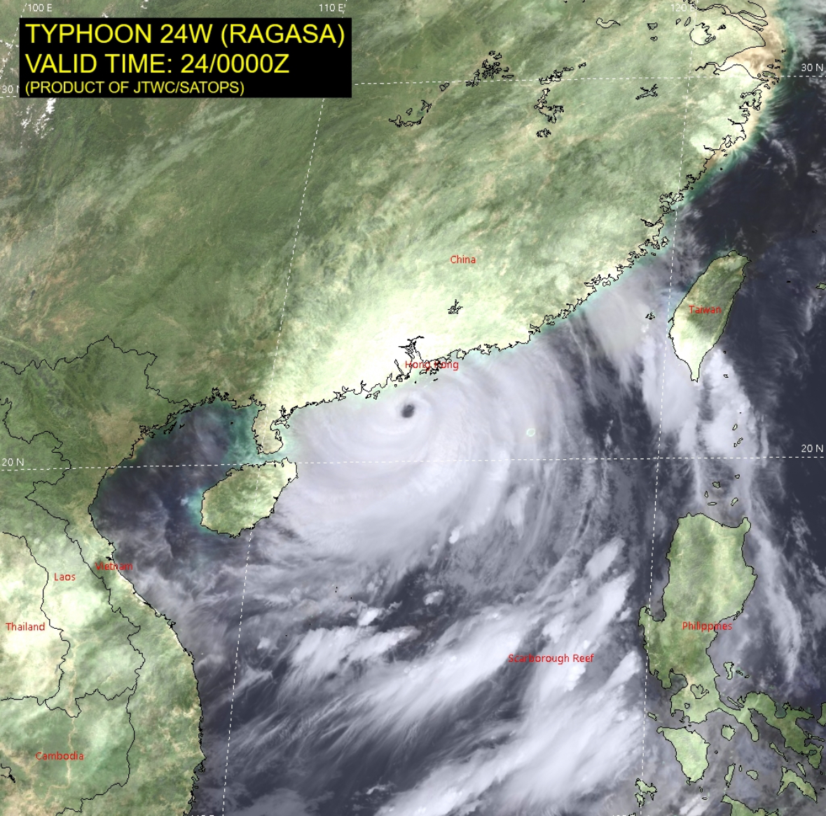
 Typhoon Ragasa looking powerful on satellite as it passes just south of Hong Kong.
- Today
-

2025 Atlantic Hurricane Season
Coach McGuirk replied to BarryStantonGBP's topic in Tropical Headquarters
Maybe we'll get something in October but it has been a bust of a season. -
Bold
-

Invest 94L—30% 2 day and 70% seven day odds of development
Cholorob replied to WxWatcher007's topic in Tropical Headquarters
Good, that isn’t a meh, that is a let’s hope nobody’s life gets ruined! . -
(002).thumb.png.6e3d9d46bca5fe41aab7a74871dd8af8.png)
E PA/NJ/DE Autumn 2025 Obs/Discussion
ChescoWx replied to PhiEaglesfan712's topic in Philadelphia Region
Some rain totals from around the area this evening. East Nantmeal 0.43" / Atglen 0.42" / Glenmoore 0.38" / Nottingham 0.05" / Warwick Township 0.23" / Chester Springs 0.28" / West Grove 0.18" /Avondale 0.15" / West Bradford 0.33" / West Chester 0.16" / Devault 0.45" / Kennett Square 0.12" / -
Yeah.. at least no Central American Gyre this time...
-
A quick .27”
-

2025-2026 Fall/Winter Mountain Thread
Daniel Boone replied to Buckethead's topic in Southeastern States
Yeah, looking like a great fall foliage Season over there. Not looking good here due to an extended dry period (2 weeks) that just ended. Some color now but many just brown, dead leaves falling. -

September 2025 OBS-Discussion centered NYC subforum
donsutherland1 replied to wdrag's topic in New York City Metro
No. The record is October 10, 2018. -
0.01 in a late afternoon shower. Quite humid, DP was 73. down to 72/70.
-
If correct, sounds similar to last year.
-
2025-2026 ENSO
Daniel Boone replied to 40/70 Benchmark's topic in Weather Forecasting and Discussion
Yeah, me too. -
September and October are the best months to get the +5 to +10 temps.
-
Hurricane watch issued for the Azores
-
Ryan Maue @RyanMaue Hurricane Season Update | Tuesday Evening September 23, 2025 High chance of both Invest 93L & 94L developing into hurricanes with a risk to the U.S. East Coast from one of them. Major intensity on table for both --> High Uncertainty Updated ECMWF 18z cycle has Humberto and Imelda moving in concert to the NNW Highly unusual to have twin hurricanes not repelling each other or orbiting a center of mass. Uncertainty = HIGH with these two systems (currently Invest 93L and Invest 94L)
-
This is quite the setup moving forward. Really need to see how 94L interacts with Hispaniola. 93L is on its way to development imo.