All Activity
- Past hour
-

2026-2027 Strong/Super El Nino
bluewave replied to Stormchaserchuck1's topic in Weather Forecasting and Discussion
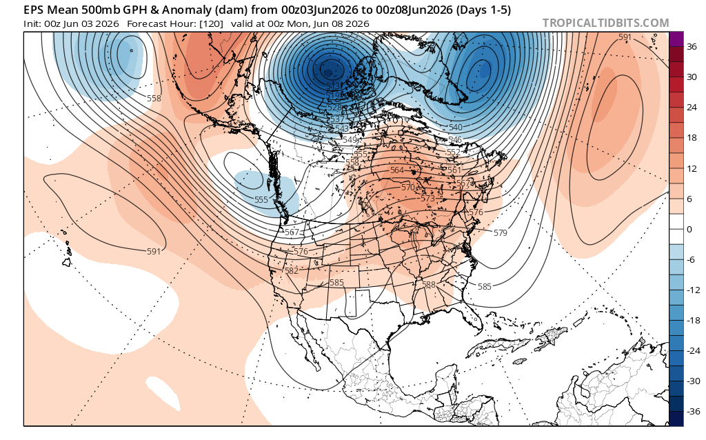
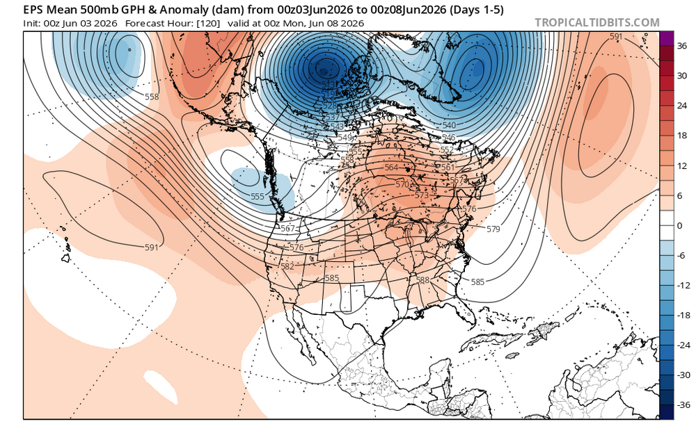
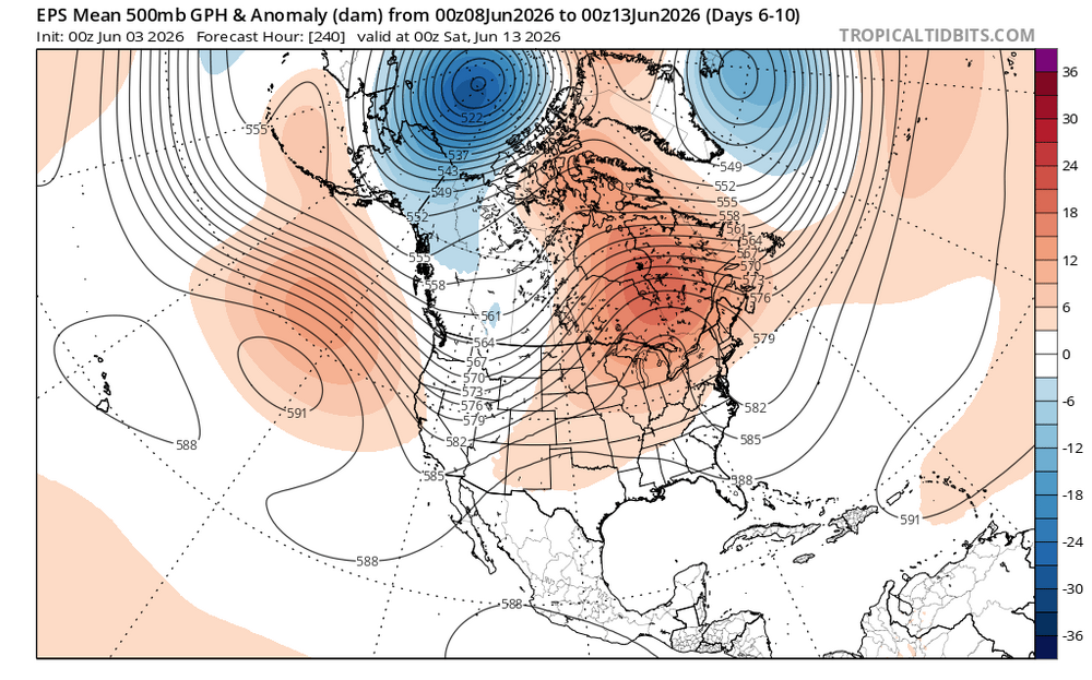
The current pattern is showing the competing influences. The typical June El Nino ridge is getting displaced further east than is usual near the Great Lakes. This is the position that we usually see this time of year with a La Niña or -PDO pattern. Probably related to the El Niño forcing shifted west closer to the WPAC +30 C warm pool and the -PDO. This would be a very warm pattern in the winter like we saw in 23-24 with the Nino ridge pressing further east than usual. If the trough can return mid month closer to the Great Lakes, then probably it would reflect the Nino forcing shifting east of the Dateline at that time. So a periodic back and forth between WPAC to Central and EPAC forcing.
-

2026-2027 Strong/Super El Nino
40/70 Benchmark replied to Stormchaserchuck1's topic in Weather Forecasting and Discussion
It's like your teaming having a lead in the top of the 2nd inning. -
2026-2027 Strong/Super El Nino
40/70 Benchmark replied to Stormchaserchuck1's topic in Weather Forecasting and Discussion
Gonna touch upon this in my June blog in a few weeks....I feel like it's better to focus more on factors like this since it's pretty obvious where we are headed intensity wise, which makes the modoki value pretty moot. -
 I think we are very dry through summer before finally turning to a wetter pattern in fall. That's why I have given up on getting a lawn going (new construction home finished in March). I will try again in September. I do expect a warm, wet winter which would be helpful.
 -
Pretty calm weather next few days; however, this is one of the worst tick years in a while. Our lab is routinely seeing near record/record numbers during our routine sampling. Take precautions out there and learn all the moles on your skin! If it has legs it isn’t a mole!
-
GFS is fighting warmth like it does ever spring and early summer. This recent series' of runs' technique was to pinch off the bottom the exiting trough into all of a 576 dm height low and act like that's sufficient to drive near gale east chilly flow into the M/A and commensurately destroying the sensible weather up and down the EC all next week. It's been showing all kinds of continuity issues with that scenario tho. 18z yesterday it pinched off almost no planetary scaled turd. Yet a coffee break in model time later it goes and stinks up the whole works with this bs at 00z. We'll see. Both the Euro, CMC and the ensembles of all three, EPS,GEPS and GEFs are less with that ordeal. The only thing going for the GFS typical fuck it up for everyone by inventing physical math is that gee ... this spring has seemed to succeed at doing that anyway. Actually in fairness the 06z GFS was less shitty looking. But therein is an example of continuity issues. I tend to think the GFS is over sensitive to curvature in the flow. In both directions - perhaps an emergent property if not error of it's 'physical machinery'. It seems to conserve too much when troughs are lifting out, and does these nip and tuck jobs too often. On the other end, it ablates the extent or ridging by fire-hosing polar jet velocities over top of the curvature like a stump grinder. It's subtle with this overall, but it's just enough to be annoying and one cannot unsee it once they get a sense of it happening with this model.
-
2026-2027 Strong/Super El Nino
40/70 Benchmark replied to Stormchaserchuck1's topic in Weather Forecasting and Discussion
Jives with my early thoughts of a very warm December for the NE on par with 2006, 2015 and 2023...essentially a super/east-based composite. Looks like an early +WPO that maybe flips later in the season. -
that would be a fascinating look on the 00z operational Euro if it were not 340 hours out ... quasi Bahama Blue pattern with a TC rollin' up inside the conveyor.
-
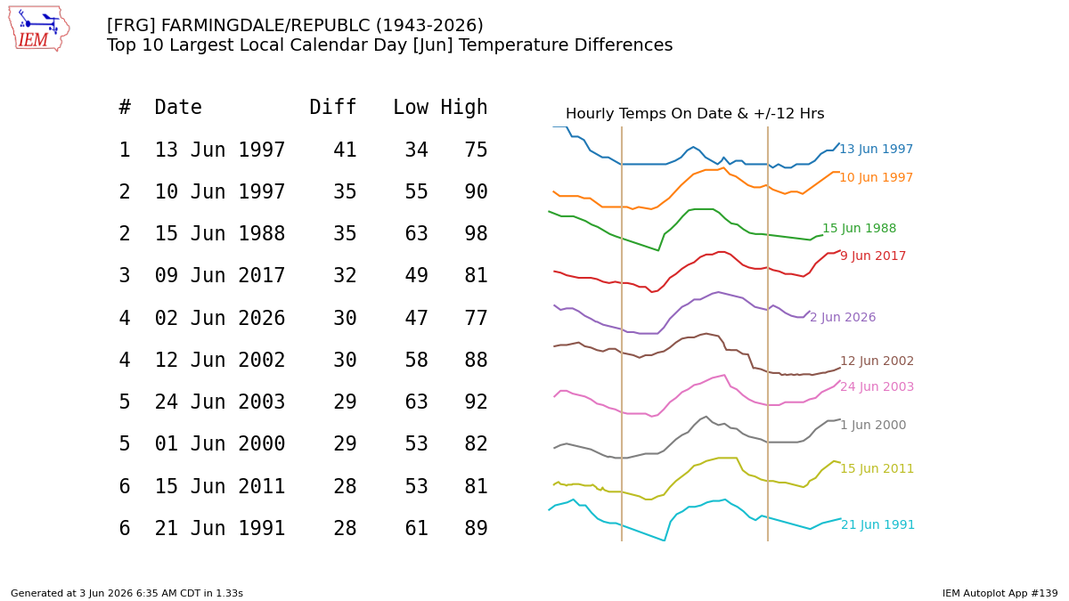
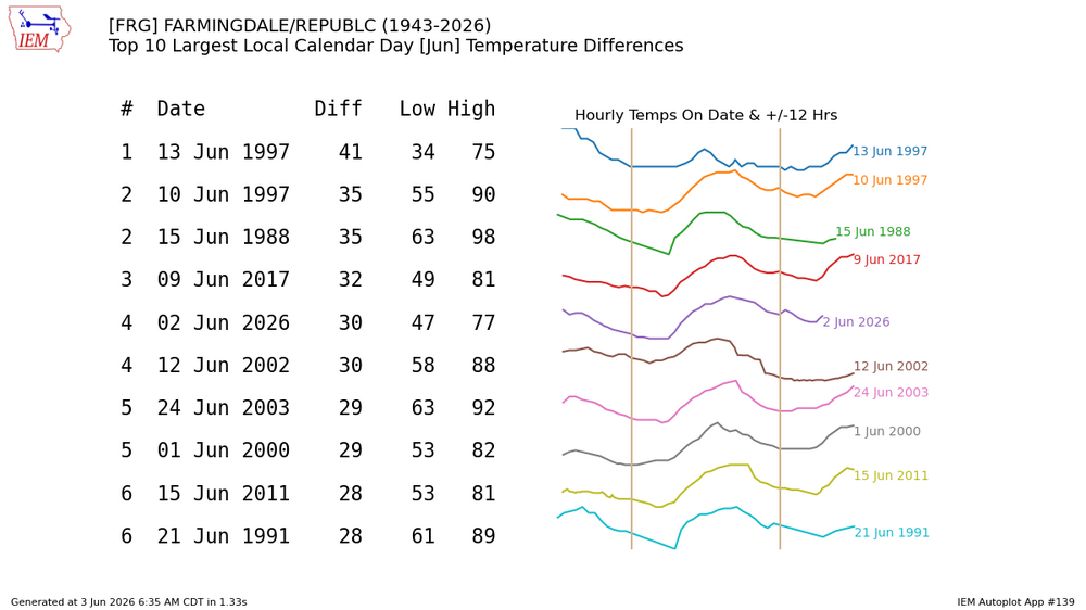
Rare 30° June daily temperature range on Long Island with how dry it has been was the 4 largest on record for Long Island during June. https://mesonet.agron.iastate.edu/plotting/auto/?_wait=no&q=139&network=NY_ASOS&zstation=FRG&v=largest&month=jun&_r=t&dpi=100&_fmt=png
-
 Euro is the most “robust” for showers on Sunday and it’s like 0.25” on average? Can keeps getting kicked on anything besides dry NW flow. So no major heat at least?
 -
2026-2027 Strong/Super El Nino
40/70 Benchmark replied to Stormchaserchuck1's topic in Weather Forecasting and Discussion
Do you really like cold and snow? Sometimes I feel like your screenname is a sadistic manifestation of deep-seeded self-loathing. -

- Today
-
Low of 49 overnight marks the warmest morning low of the year at my place. A very warm and dry day on tap. Should reach low 80's.
-

Junorch obs and discussion 2026
Damage In Tolland replied to Damage In Tolland's topic in New England
Dewy -
Much of central (and western) North Carolina got down into the 40s this morning.
-

Central PA Summer 2026 Discussion/Obs Thread
mahantango#1 replied to Voyager's topic in Upstate New York/Pennsylvania
44 this morning. -

Central PA Summer 2026 Discussion/Obs Thread
Mount Joy Snowman replied to Voyager's topic in Upstate New York/Pennsylvania
52 when I left the house. Oh what’s that, you’d like another perfect weather day? Your wish is my command. -

Central PA Summer 2026 Discussion/Obs Thread
pawatch replied to Voyager's topic in Upstate New York/Pennsylvania
41 degrees this morning. Gone fishing -
RDU has at least tied the record low for today (49)
-
Central PA Spring 2026 Discussion/Obs Thread
pawatch replied to Voyager's topic in Upstate New York/Pennsylvania
41 degrees this morning. -
Looks like some models are hinting at finally some warmth and dews possibly beyond mid month, which would start to make sense climatologically.
-
Temp down to a beautiful 43 degrees currently.
-

2026-2027 Strong/Super El Nino
snowman19 replied to Stormchaserchuck1's topic in Weather Forecasting and Discussion
-
We got smacked again tonight by a complex of storms that dumped another inch of rain on Buda ! Now we are up to 22 inches on the year. Normal is 30 inches for the entire year. We are just stackin 'em, rackin' em and packin' em in every time we turn around! The line starts at the Mississippi and everyone better take a number! With another disturbance forming in the Gulf of Mexico, and a Brobdingnagian El Nino intensifying, I think this summer could end up being like 2021, 2014 and 2015 and 2007. This is becoming surrealistic. Usually places like Dallas, TX and WinStar Casino in Oklahoma are at 6 inches above us here in Buda. This year it is inverted. Buda is 6-7 inches ahead of Dale City. It's absolutely unheard of! I want that Super Nino SO BAD! I want feet and feet of rain all year!
-
I'm really looking forward to 8 weeks of posts arguing if it will be 85F or 88F. It's summertime, let's enjoy it!