All Activity
- Past hour
-
From an Evansville, IN, pro-met These were the observations at Evansville, IN for 4-5-6pm on July 26, 2026. The dew point readings were 80-80 and 81. The 81 deg. F dewpoint tied the record for highest dew point in history at this location. It happened on 4 previous occasions.
-
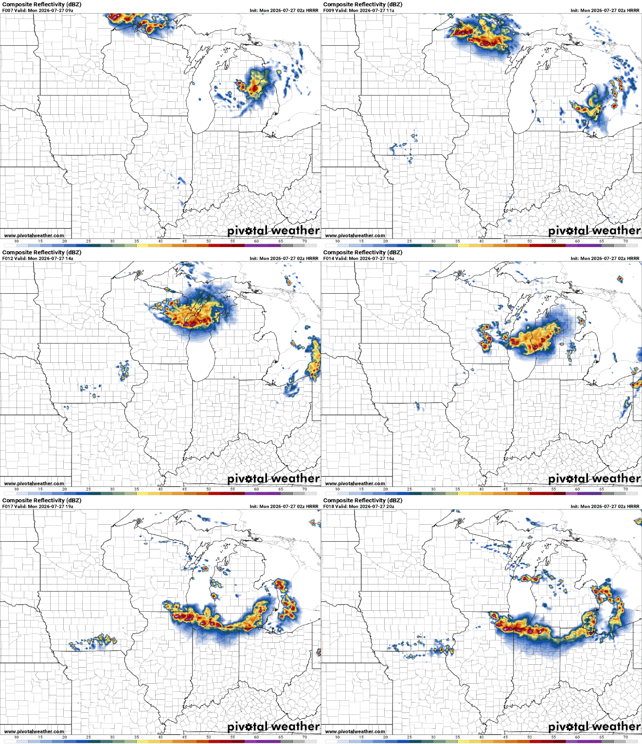
HRRR selling a derecho late morning to early afternoon tomorrow
-
I picked a bad day for baling hay. I think I lost 10lbs water weight. Sent from my SM-G991U using Tapatalk
-
 Bet on the wetter look…it’s been this for the last 3 months. Every frieken week we kill it. Let’s do it again Tuesday plus. It wants to rain mid week..every week. Here we go. Lawns green as can be here…looks like we keep it going!
 -
Heck yeah I’m down for that yeah there more thunderstorms developing in ky sliding on down .
-
Looks like there's been some expansion upstream of me in Kentucky, so it may actually storm here. As Jax noted, probably gonna be a ton of lightning and thunder with these.
-
50-60mph?
-
should get a good light show in the next few min,plenty of instability to work with
- Today
-
I got above 97 for a bit this afternoon. Highest I've recorded on my PWS. I just hope the monsoon hype verifies this week.
-
Baseball sized hail warned storm NW of Richmond don’t see that very often around here
-
When your opposition calls you a "evil communist" and your retort is to post appreciation for actual evil communists...
-
Nor'easter in July?
-
Low of 67. Nice walk this morning with the pup.
-
Not sure how accurate it is, but Kennett’s ob at 1:35 pm local time was 97/88/136. Dew is up to 80 in Rockford and 76 here.
-
That was a fun little storm that rolled through Leesburg earlier. Didn't last long, but got a little rowdy and dropped 0.25" of rain.
-

2026-2027 Super El Nino
snowman19 replied to Stormchaserchuck1's topic in Weather Forecasting and Discussion
A new CCSR/IRI update indicates [emoji305] A clear bias toward a positive phase of the Indian Ocean Dipole (IOD) during the fall of 2026. [emoji409] The highest probabilities reach around 84% during September and October. [emoji408] The multi-model average predicts a peak for the index of +1.5°C, with some individual scenarios higher -
Looks like the MCS will just miss my area to the west. Hopefully there's not much wind damage in the mid-state from it. The heat was unbelievable today along the Mississippi river, under the heat dome. I saw some HI temperatures up towards 120 along the river from Memphis to St Louis. The hotter it us, usually the stronger the winds without the storm complex.
-
 Of course he did because he's a complete moron. Hopefully he gets 6" of rain and his basement floods
 -

2026-2027 Super El Nino
40/70 Benchmark replied to Stormchaserchuck1's topic in Weather Forecasting and Discussion
@raindancewxMakes perfect sense to me....1997 obviously for ENSO given intensity, but the rest are great polar analogs...only one I don't have is 2018, but that will probably be there when I do the extra tropical Pacific next month. -
2026-2027 Super El Nino
40/70 Benchmark replied to Stormchaserchuck1's topic in Weather Forecasting and Discussion
You missed my point. I agree it favors the mid atl for above average snowfall, that isn't my point. The "equal chances" stance is crap. Make a call. I'm not directing this specifically at you. -
Buddy. When it’s 90 in Montauk and Weshampton and JFK and 86 in the park, it’s not an agenda or a conspiracy, it’s a temperature that’s not representative of the area. Don’t tell me it’s cooler in Central Park than all of the coastal terminals in early summer. Enough.
-
Been saying this for years. There is an agenda here. Easy to see why Central Park would be cooler than the concrete hell holes that LGA and EWR are. Now the concrete hellhole airports may be more representative of NYC climate as a whole, but that is another discussion. That is vastly different then the pushed conspiracy theory that CPK temp readings are wrong
-
Visiting Deep Creek Lake for basically the first time (stopped in once in the fall 10 years ago). Any suggestions of scenic/photogenic/natural places to visit? I have DCL SP, Herrington Manor, & Swallow Falls on my list to visit. Also potentially Coopers Rock & Blackwater Falls too.
-
 Probably convection thrown into that too. Mesos will be interesting tomorrow.
 -
We’re done with Venus heat and sun even not quite the full pop now. So analogs say what I hear called “home brew “ for August and at or below temps