All Activity
- Past hour
-

January 25/26 Jimbo Back Surgery Storm
Brick Tamland replied to Jimbo!'s topic in Southeastern States
-

January 25-26 Winter Storm Potential
mattinpa replied to Ralph Wiggum's topic in Philadelphia Region
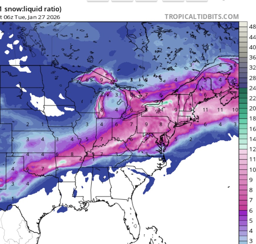
I like the fact that models are slightly weaker with the primary. Could lead to close to the GFS eventually. It should be at least 6-12 inches area wide regardless. -
we were this close to a ghd 1 setup this weekend…
-
-

Central PA Winter 25/26 Discussion and Obs
paweather replied to MAG5035's topic in Upstate New York/Pennsylvania
Is the GFS a later start time? -

January 25-26 Winter Storm Potential
Birds~69 replied to Ralph Wiggum's topic in Philadelphia Region
6abc: (Seems alright. Remember this is for Philly, more mixing may occur. Burbs more.)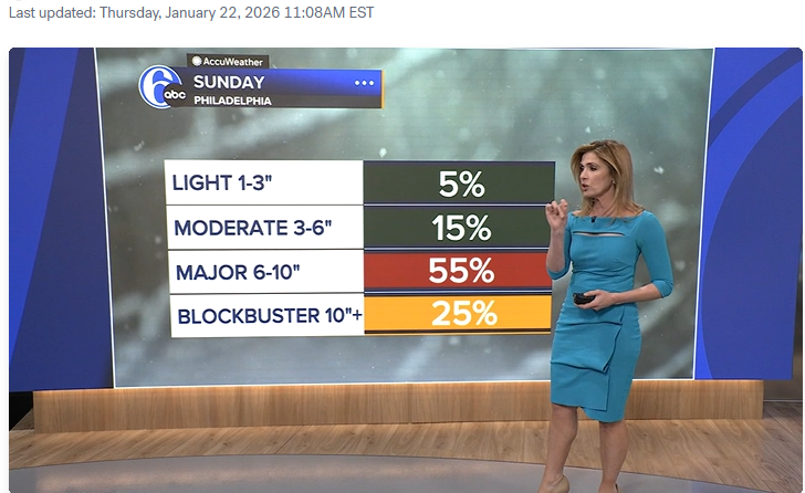
-
An excellent choice my liege
-

1/24-1/25 Major Winter Storm - S. IL, IN, MI and OH
buckeye replied to A-L-E-K's topic in Lakes/Ohio Valley
as much as I'd love that /\ this has more of a realistic feeling to it.
-
Can somebody please print the entire region sleet map? Thanks!
-

January 24-26: Miracle or Mirage Thread 2
SomeguyfromTakomaPark replied to mappy's topic in Mid Atlantic
Agree, nothing is showing less than 0.5 QPF before a change over and ratios should be decent or better. -

Possible Record Breaking Cold + Snow Sunday 1/25 - Tuesday 1/27
eduggs replied to TriPol's topic in New York City Metro
Should be interesting model runs later today and especially tonight. We are riding the edge between a significant event and something historic. A small shift either way from this spot will make a huge difference in the feel and impact of the event. -
Enjoy it... probably wont break freezing for the next 7 days
-

“Cory’s in LA! Let’s MECS!” Jan. 24-26 Disco
HoarfrostHubb replied to TheSnowman's topic in New England
I felt it was a bit lazy. CoastawxJr's map had more thought that went into it between giving kids swirlies -
Canadian is like the GFS, but more zr around here.
-

January 25/26 Jimbo Back Surgery Storm
Blacksburg Coach replied to Jimbo!'s topic in Southeastern States
-

Possible Record Breaking Cold + Snow Sunday 1/25 - Tuesday 1/27
MANDA replied to TriPol's topic in New York City Metro
All guidance has been consistent for a few days now on .9 to 1.2" of QPF. A few ticks up / down at times but in general have been locked in on around 1" of liquid. -

Possible Record Breaking Cold + Snow Sunday 1/25 - Tuesday 1/27
VlinderF replied to TriPol's topic in New York City Metro
Greetings! During this period of model-hugging and pointless arguing, I thought I'd introduce myself. I'm a looongtime lurker, going back to the days of Bill Evans's WABC board, when metsfan/snow88/MJO was just a young whippersnapper working at CVS. Lurked on Eastern and the NYC Metro Weather forums for a long time too, but mostly here now. As one of the rare folks in this forum who actually lives near Central Park, I thought I'd throw my hat in the ring. Hoping for some good snow soon, as it's been...a while around here. Also thought this forum could benefit from someone who can actually vouch for the measurements in CPK, which, honestly...usually sound about right to me. This last Sunday, while the Park reported 0.4 in the morning (on grass that had a little from the day before), in the surrounding neighborhood we got ZERO/NADA/white rain until the evening round, when we picked up about an inch, and only then on grass/cars/etc. It really is different in Manhattan in those borderline-ass storms. But for this weekend, even 6 inches of solid snow and a sleet-fest on top would be the most exciting winter weather around here since about 2021. Here's hoping. -

Possible Record Breaking Cold + Snow Sunday 1/25 - Tuesday 1/27
OrangeCTWX replied to TriPol's topic in New York City Metro
Ya technically the CMC is a slight improvement from a low/temp perspective. Fingers crossed this is the most northern model and things maybe even shift south a slight bit. -
The NAM's 2.5-3" of sleet on top of that snow will be hilarious if it verifies. I remember a 3" sleet storm in like 2017 or 2018 and it was a concrete mess.
-
Yeah, it is actually making me sick at my Stomach. Electric will surely be out for quite some time if that's realized barring a Miracle.
-
January 24-26: Miracle or Mirage JV/Banter Thread!
SomeguyfromTakomaPark replied to SnowenOutThere's topic in Mid Atlantic
You're in a good spot for this one. I hope you get 18 inches. I'll be happy with my 6-10+ plus ice. -

Possible Record Breaking Cold + Snow Sunday 1/25 - Tuesday 1/27
psv88 replied to TriPol's topic in New York City Metro
Eduggs is on it. -
Largely similar to 0z. Certainly not bad.
-

2025-2026 Fall/Winter Mountain Thread
calculus1 replied to Buckethead's topic in Southeastern States
Looking at the ZR totals posted above on the 12Z GFS, the northern foothills from Burke, Caldwell, and Catawba northeastward seem to hold on to the coldest upper levels the longest. This results in epic IP accumulations and much less ZR. We are in the primo position for CAD, and it may save us on the ZR, in this instance, keeping us IP much longer. -
January 25/26 Jimbo Back Surgery Storm
Blacksburg Coach replied to Jimbo!'s topic in Southeastern States