All Activity
- Past hour
-
Lots of fine ways to jackpot in a storm
-
I would think so since this is something that gradually built up rather than what happened in @tamarack's story. It directly hangs over another smaller section of the building.
-
I forgot to mention this yesterday, but one of the Glacier National Park web cams had water drops, that is, rain. That is a result of such warm air.
-

December 2025 regional war/obs/disco thread
weatherwiz replied to Torch Tiger's topic in New England
I bet they enjoyed a good ice storm -
December 2025 regional war/obs/disco thread
weatherwiz replied to Torch Tiger's topic in New England
Santa's been around since the start of time -

December 2025 Short/Medium Range Forecast Thread
Daniel Boone replied to John1122's topic in Tennessee Valley
Thanks brother ! I hope and pray your Wife gets well and you stay healthy. Dr said Flu was bad here too. He said Covid was too but it's Symptoms haven't been as bad as the other Viruses. -
Never fails for Christmas. Lol idk why it irritates me so damn bad, I do like that millions of other peeps will be turning on the AC during dinner. Lol
-

December 2025 regional war/obs/disco thread
Snowcrazed71 replied to Torch Tiger's topic in New England
Yeah, Kris Kringle or Jesus weren't even birthed yet.. lol -
So Euro caved?
-

December 2025 Short/Medium Range Forecast Thread
Matthew70 replied to John1122's topic in Tennessee Valley
Get better soon. My wife has been battling a cough congestion over a month now. She never gets sick. The flu from all accounts is brutal this year. -

2025-2026 ENSO
donsutherland1 replied to 40/70 Benchmark's topic in Weather Forecasting and Discussion
Since 1980, for December cases with a WPO of -2 or below: PNA<0: 84.1%; PNA>0: 15.9%. -
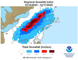
Today is the 5th anniversary of the December 2020 snowstorm. This weekend's snowstorm was the biggest December snowstorm since then.
-

Central PA Winter 25/26 Discussion and Obs
2001kx replied to MAG5035's topic in Upstate New York/Pennsylvania
-5 just outside of Houtzdale this morning. -
December 2025 Short/Medium Range Forecast Thread
Daniel Boone replied to John1122's topic in Tennessee Valley
A -AO allows for the Cold in the Arctic and Northern Lats to spill further South. +AO tends to keep it bottled up North. It's not guaranteed cold here as if other Drivers force a Trough in the West it can still be mild here. It however increases odds of the real Cold air of reaching the lower Latitudes by a good margin. Doesn't mean you can't get it to get cold , or even snow in our area with a +AO as sometimes with the right 500 mb Setup CPF can occur. -
The scary thing to see is that for the foreseeable future, including into early January, most of the cold is bottled up in Canada and New England. While cold air can be brought down by a storm, CONUS will be literally almost entirely void of snow and cold through early January. This prime time for building snowpack up north and west which can held cool down some temperatures. At some point that ridge will have to roll over and we'll take that warmth on the chin. It would be preferable to have some storminess and cold to ring in the New Year
-
We probably need some heavy changes if we're gonna get that 12th straight La Nina +PNA Jan after a -PNA Dec. I don't see a -2.5 on 12/31 flipping to positive before 1/10 or 1/15. Does not mean we won't see cold and snow though if the AO/NAO are negative
-

December 2025 regional war/obs/disco thread
weathafella replied to Torch Tiger's topic in New England
Lol…their lifespan was 30 something. -
I wasn’t born yet lol but looking back on the weather history, the 1989-90 winter was probably (easily) the most extreme pattern flip we’ve seen in the last 50 years. We went from a record cold arctic tundra starting in November right through the end of December, then got a big cutter on New Year’s Eve and that was all she wrote, light switch flip to an unmitigated torch for all of January and February….
-
-
I received 7" in Syosset on my snowboard (white azek board). I'm sure I could have gotten 8" plus going around my yard with a ruler into the ground.
-
I was too young (about a year and a half), but the weather records show that the January 1990 average temperature was 15 degrees warmer than the December 1989 average temperature. That type of temperature jump is something you see from March -> April or April -> May. You don't see that in the dead of winter. It's like spring began in January that season.
-
December 2025 Short/Medium Range Forecast Thread
Daniel Boone replied to John1122's topic in Tennessee Valley
Yeah. I still have this Upper Respiratory Virus. 12 days so far. Dr says it has now led to a Sinus and bronchial Infection. So, yeah would be a nice break with a mild period and more moisture in the air. Be careful out and about folks. Alot of nasty stuff going around. Dr even said the regular cold virus is stronger and harder to shake than usual. -
just have to hope the -NAO doesn't hook up with the SE ridge
-
(002).thumb.png.6e3d9d46bca5fe41aab7a74871dd8af8.png)
Central PA Winter 25/26 Discussion and Obs
ChescoWx replied to MAG5035's topic in Upstate New York/Pennsylvania
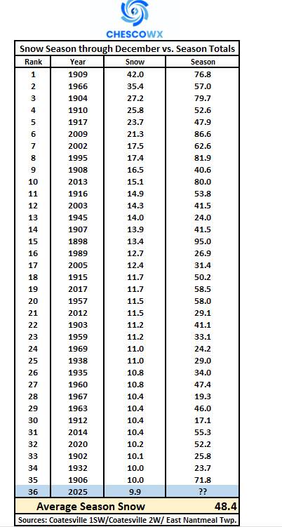
With this week's snow event across Chester County PA we are now up to 9.9" of snow so far this season. Through the end of December our typical average snow total is 7.1". So, what could this mean for our snow totals by the time the final flake falls possibly as late as April? Well to date this is the 36th snowiest December with records back to 1893. Below is all 36 years along with where we ended up for seasonal snow that winter. Of note 25 of the 35 years or 71% of the time we ended up with above average seasonal snowfall. Average seasonal snowfall ranges between 32" to 36" across the county. The overall average snowfall across these 35 years was 48.4" of snow. The greatest seasonal snow was the 95.0" that fell in 1898-1899 and the least was the 17.1" in 1912-1913. For Team Snow you should feel fairly good that we end up with above average snowfall this season.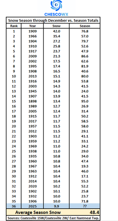
-
E PA/NJ/DE Winter 2025-26 Obs/Discussion
ChescoWx replied to LVblizzard's topic in Philadelphia Region
With this week's snow event across Chester County PA we are now up to 9.9" of snow so far this season. Through the end of December our typical average snow total is 7.1". So, what could this mean for our snow totals by the time the final flake falls possibly as late as April? Well to date this is the 36th snowiest December with records back to 1893. Below is all 36 years along with where we ended up for seasonal snow that winter. Of note 25 of the 35 years or 71% of the time we ended up with above average seasonal snowfall. Average seasonal snowfall ranges between 32" to 36" across the county. The overall average snowfall across these 35 years was 48.4" of snow. The greatest seasonal snow was the 95.0" that fell in 1898-1899 and the least was the 17.1" in 1912-1913. For Team Snow you should feel fairly good that we end up with above average snowfall this season.