All Activity
- Past hour
-

Central PA Winter 25/26 Discussion and Obs
canderson replied to MAG5035's topic in Upstate New York/Pennsylvania
Today is the anniversary of the 2016 storm that dropped the most snow in a single event ever in Harrisburg. 32” was actually too much snow - had to have front-end loaders and dump trucks remove snow from our area to get out many days later. -
 I think with the early morning snow in Chattanooga and south we all got the Ideal that things were going to be early, and I guess that was true, but the main moisture was supposed to hold off until around 4 to 5pm. I think that is what is going to happen because even when I get what looks like good returns over me, it is just light snow. Of course as soon as I say that II am having my biggest dimes and Quarters right now.
 -
Can also thank the satanic panic-esque reaction to nuclear decades ago for lack of viable off-ramps from coal usage.
-

Extreme Cold, Snow & Sleet: SECS 1/25 - 1/26
Miller A replied to TriPol's topic in New York City Metro
I am hating being the dividing line here in TR. At this point I assume warm air wins. It always does and this means maybe 5” along the coast Would prefer a sleet fest over a slop fest. Both suck to clean, but at least it can give you that mood snow feeling I was in such a good mood a few days ago and now I feel foolish for thinking there would be no major changeover -

2025-2026 Fall/Winter Mountain Thread
Maggie Valley Steve replied to Buckethead's topic in Southeastern States
Light snow with a little sleet currently. -

Texas 2026 Discussion/Observations
DFWWeather replied to Stx_Thunder's topic in Central/Western States
From FWD: Heavier intensity precipitation will start after dark and should primarily be sleet. We'll continue with moderate sleet from 02Z through the overnight, however there is some concern that we could see a quicker transition to snow if lift is stronger than anticipated. If that occurs, then snow could be heavy at times. For now, we'll continue to monitor this and carry a snow/sleet mix after 10Z with a transition to all snow by 14Z. Precipitation should start to taper off around midday Sunday. Overall the vertical column has been cooling much quicker than models have forecasted. -

Southern Crippler - Get well soon Jimbo Storm Obs
WeatherHawk replied to BooneWX's topic in Southeastern States
24 in Jefferson, Ashe County, NC and a a light fine snow just started falling as of 2:01pm As with most systems here, it’s early. Be safe everyone and good luck! -

“Cory’s in LA! Let’s MECS!” Jan. 24-26 Disco
mahk_webstah replied to TheSnowman's topic in New England
At least up here that seems to have bumped it up a couple more tenths -

January 24-26: Miracle or Mirage JV/Banter Thread!
WhiteoutMD replied to SnowenOutThere's topic in Mid Atlantic
Nashville look at this transition line https://weather.cod.edu/satrad/nexrad/index.php?parms=OHX-N0C-1-24-100-usa-rad -
I think with hurricanes people would be justified to be upset. From putting up shutters to evacuating, the preparations are costly and time consuming. I wonder how much of the economic loss from a storm like this is simply due to business closures, school closures, and people just cancelling their plans. Either the persistent biases in these models need to be corrected or better communication tools need to be developed. Don't get me wrong, the local mets do good job of trying urge caution. But most people simply look at their weather app, and it takes a few years of living in a place like Charlotte to realize that when a snowflake shows up in a forecast, it is a hallucination, a computer glitch.
-
19 degrees and first flakes! Extremely light and you have to concentrate to see them but considering how quick I'll probably flip to sleet, every single flake counts lol. NWS forecast for onset of accum precip is 7pm but anything that falls will stick so hopefully I can get some bonus snow
-

Central PA Winter 25/26 Discussion and Obs
Blizzard of 93 replied to MAG5035's topic in Upstate New York/Pennsylvania
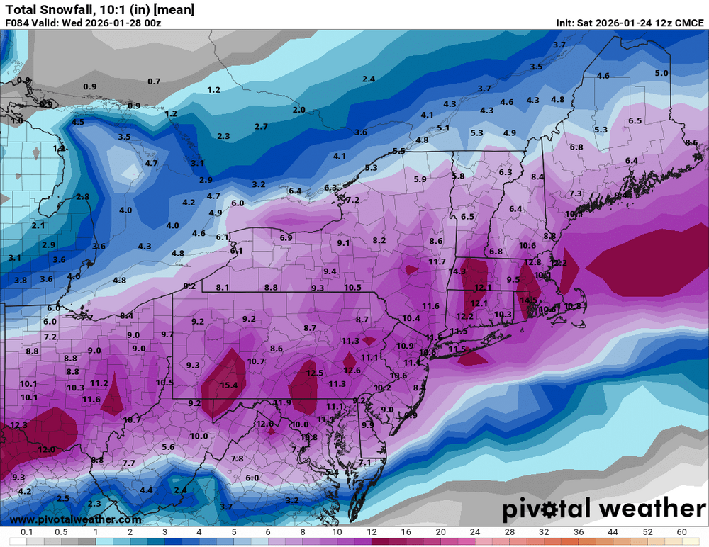
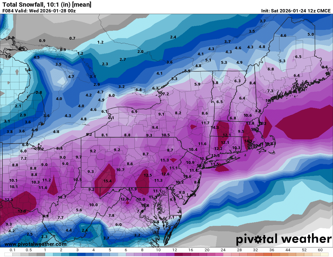
From our long lost friend @mitchnick in the other thread… No GGEM or RGEM, but the Geps updated and here's its snowfall. Not bad folks. EDIT: Obviously includes sleet at 10:1 -

Extreme Cold, Snow & Sleet: SECS 1/25 - 1/26
MJO812 replied to TriPol's topic in New York City Metro
This is fine -

“Cory’s in LA! Let’s MECS!” Jan. 24-26 Disco
SeanInWayland replied to TheSnowman's topic in New England
Please tell me that's a 10:1 from the QPF and I'll be a happy man -

Southern Crippler - Get well soon Jimbo Storm Obs
Blue Ridge replied to BooneWX's topic in Southeastern States
Bottomed out at 25.5 around noon. Now 26.4/-0.9. Consistently gusting 15-20 mph. Holly Springs, NC -

Jan 24-26 Weekend Snow and Sleetfest Model Thread Part Tres
baltosquid replied to H2O's topic in Mid Atlantic
This was wetter than 00z. Really dirty, but if you take the 06z RGEM changeover times and maybe go an hour earlier because of the trends, maybe metros can touch ~0.7in QPF before the switch. With downside risk of course... -

Extreme Cold, Snow & Sleet: SECS 1/25 - 1/26
EastonSN+ replied to TriPol's topic in New York City Metro
To his credit he did mention a couple days ago this had bust potential for DC through NYC due to more mixing. -
 My children’s school has just canceled school Monday and Tuesday.
 -

Jan 24-26 Weekend Snow and Sleetfest Model Thread Part Tres
paulythegun replied to H2O's topic in Mid Atlantic
My guess...they have like 6+ other hires models to look at that are better than NAM, if you include all the experimental ones. -

“Cory’s in LA! Let’s MECS!” Jan. 24-26 Disco
weatherwiz replied to TheSnowman's topic in New England
earlier this decade -
Jesus. CMC would have been a snow bomb then.
-

Pittsburgh/Western PA WINTER ‘25/‘26
Mailman replied to Burghblizz's topic in Upstate New York/Pennsylvania
Latest map: -
Extreme Cold, Snow & Sleet: SECS 1/25 - 1/26
EastonSN+ replied to TriPol's topic in New York City Metro
That's the first time I have ever seen then update their maps twice in 2 hours lol. -
 I agree..there’s not the continuity of precip that we saw on the models. That gap in precip back in Arkansas is massive.
 -

Extreme Cold, Snow & Sleet: SECS 1/25 - 1/26
nycsnow replied to TriPol's topic in New York City Metro
Somehow cmc ensembles ran but anyways their a goooood hit