All Activity
- Past hour
-

1/24-1/25 Major Winter Storm - S. IL, IN, and OH
buckeye replied to A-L-E-K's topic in Lakes/Ohio Valley
Flurries started here (cmh area) -
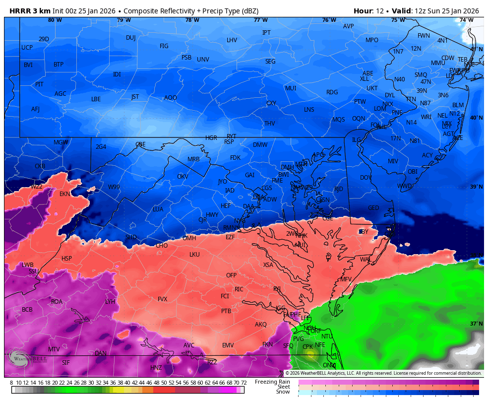
WB 0Z HRRR 7am

-
Traffic cams show flakes in EZF. Monitoring Stafford for next.
-

Southern Crippler - Get well soon Jimbo Storm Obs
lilj4425 replied to BooneWX's topic in Southeastern States
Huge bust. Nothing here in Greenville. At least my power won’t be out for a week now. -

Southern Crippler - Get well soon Jimbo Storm Obs
Coach McGuirk replied to BooneWX's topic in Southeastern States
22.3 and flurries, temp slowly rising. -

Richmond Metro/Hampton Roads Area Discussion
overcautionisbad replied to RIC Airport's topic in Mid Atlantic

-

Pittsburgh/Western PA WINTER ‘25/‘26
ChalkHillSnowNut replied to Burghblizz's topic in Upstate New York/Pennsylvania
Exactly-so happy for the forum to cash in! -

Arctic Hounds Unleashed: Long Duration Late January Cold Snap
512high replied to WxWatcher007's topic in New England
5F.....Winter, nice! -

Richmond Metro/Hampton Roads Area Discussion
Sernest14 replied to RIC Airport's topic in Mid Atlantic
Almost seems as if the precip on radar is moving more flat/southern than models are showing -
17 here. Outside stacking wood awaiting the first flakes. It feels like snow all around
-
9/-9; I’m in the cold camp. Let’s get it!
-
welcome to the beautiful Eastern Panhandle!
-

MO/KS/AR/OK 2025-2026 Winter Discussion
stormdragonwx replied to stormdragonwx's topic in Central/Western States
Yeah I am totally over this storm. Looks like it's gonna stay sleet with an incoming dry slot. -

Southern Crippler - Get well soon Jimbo Storm Obs
Blacksburg Coach replied to BooneWX's topic in Southeastern States
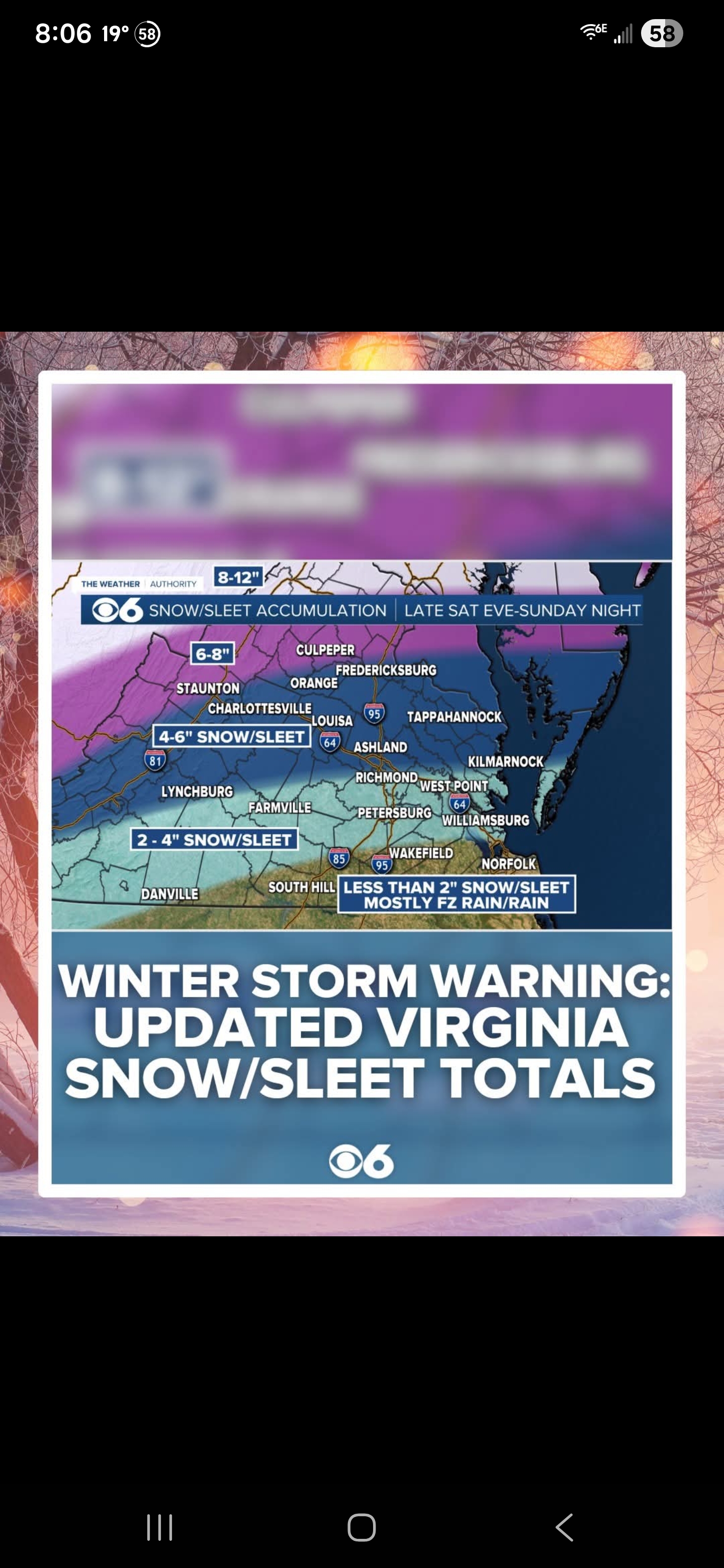
Given the above, still think sleet will be the predominant precip type for a while on Sunday, but some guidance now indicating an earlier transition to freezing rain, especially across the VA/NC border and south. With the higher confidence of more freezing rain, have kept ice amounts to 0.4" to 0.75" for most of North Carolina and southern/SW Virginia, with localized higher amounts along the crest of the Blue Ridge. This is a significant amount of ice... downed trees and power lines, resulting in extended power outages are now becoming more likely. Since sleet typically has a liquid equivalent ratio of roughly (2- 1/3-1), we could potentially see additional sleet totals on top of any snow that falls early on in the event. The snow that does fall into this extremely cold and dry airmass will be very fluffy and light, while the sleet that falls on top, combined with freezing rain, will lead to a heavy crust on top of the previously fallen snow. -
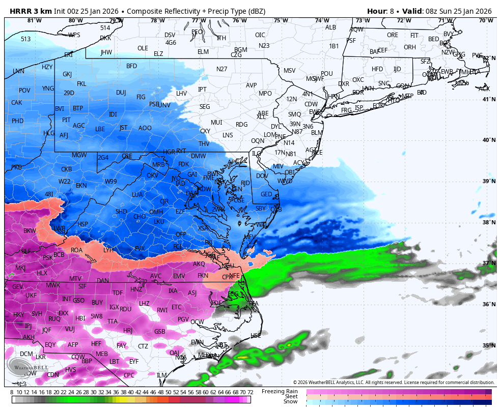
WB 0Z HRRR overspreading DC by 1 am, all but far NE MD by 3am

-
Nope, he’s out for dinner right now. wonder if he’ll go to bed Sunday night
-
15.1/1.1 here in 21057
-

January 24-26: Miracle or Mirage OBS Thread!
EastCoast NPZ replied to Jebman's topic in Mid Atlantic
Moon is out here. -
Sleet has really picked up, but just like others are saying, there is definitely freezing rain mixed in leaving a glaze already.
-

MO/KS/AR/OK 2025-2026 Winter Discussion
MoWeatherguy replied to stormdragonwx's topic in Central/Western States
Thanks, all. -
 We pass the obs thread juju baton. Let’s get a region wide crushah.
 -

“Cory’s in LA! Let’s MECS!” Jan. 24-26 Disco
Damage In Tolland replied to TheSnowman's topic in New England
Think “dad” is posting as Junior tonight from bed -

Extreme Cold, Snow & Sleet: SECS 1/24 - 1/26
Bxstormwatcher360 replied to TriPol's topic in New York City Metro
Boogie down here. -

Pittsburgh/Western PA WINTER ‘25/‘26
SteelCity87 replied to Burghblizz's topic in Upstate New York/Pennsylvania
Well guys, let's bring her home. The majority of us have been on these forums in some capacity for 15-20 years. We know we don't get these chances often and we know how rare even a 12+ storm is. It's such a niche group but I'm thankful to have others who share my excitement over frozen liquid. Let's hope this makes up for all of the close calls, screw jobs and rug pulls over the the last 10 or so years. We deserve this one! -
Hopefully