All Activity
- Past hour
-
 18z HRRR tries to pop a few supercells ahead of the main line. Impressively amps up the STP across Indiana and Michigan as the LLJ strengthens.
 -
Models calling for coastal low next Thu/Fri with rain and highs only low/mid 50s -- yuck! The first part of the week looks great though
-

E PA/NJ/DE Spring 2025 Obs/Discussion
RedSky replied to PhiEaglesfan712's topic in Philadelphia Region
The sun peeked out and it feels like 85F Dew city -
I just assumed this was due to lingering effects of the SSW. It was impressive with an extended -AO. But who knows.
-
 Tornado Watch likely in next hour or two for S WI/ N IL https://www.spc.noaa.gov/products/md/md0791.html Mesoscale Discussion 0791 NWS Storm Prediction Center Norman OK 0214 PM CDT Thu May 15 2025 Areas affected...Parts of southern Wisconsin into northern Illinois Concerning...Severe potential...Tornado Watch likely Valid 151914Z - 152115Z Probability of Watch Issuance...80 percent SUMMARY...A tornado watch will likely be needed this afternoon. Supercells capable of all severe hazards are expected within the next few hours. DISCUSSION...Cumulus continue to deepen both along a dryline and an area of confluence within the Mississippi Valley. Whether storms develop within the confluence or when the dryline reaches the Mississippi River remains a question. 40-50 kts of effective shear across these surface convergence zones will favor supercells as storms develop. Large to very large hail will be a concern as well as severe wind gusts. The 18Z DVN sounding sampled very steep mid-level lapse rates and a long hodograph. Tornado potential will also be present. Surface temperature/dewpoint spreads are near 20 F, but low-level shear and a supercellular mode will favor low-level rotation. The time frame of greater tornado potential will likely be 22-00Z when the low-level jet increases in southern Wisconsin. ..Wendt/Mosier.. 05/15/2025 ...Please see www.spc.noaa.gov for graphic product... ATTN...WFO...GRB...LOT...MKX...DVN...ARX... LAT...LON 41418999 41579025 41819042 42309082 42909119 43299134 43549126 44009048 44358993 44438931 43978880 43168862 42128827 41798867 41418999 MOST PROBABLE PEAK TORNADO INTENSITY...120-150 MPH MOST PROBABLE PEAK WIND GUST...65-80 MPH MOST PROBABLE PEAK HAIL SIZE...2.00-3.50 IN
 -
Mention of "some thunderstorms may be severe" in the updated zones for Friday night
- 528 replies
-
- 2
-

-
- severe
- thunderstorms
- (and 2 more)
-
 https://x.com/TornadoWIS/status/1923091119270662400 These kids are insufferable.
 -
 Bout to get rocked here. Southern metro watch out. Tor warned storm entering the I-35 corridor
 -
If it's a legit snow storm with damage. If it's a half inch of slop with mostly windswept rain all weekend, then I think everyone would pass.
-
Nothing worse than rain and high humidity. The forecast busted here today it's been drier less humidity and mostly sunny FINALLY.
-
So nice to have lower humidity today with mostly sunny skies here, I was outside for lunch and it felt absolutely wonderful.
-
Another significant rainfall event, especially for the Western areas, may be possible the middle of next week prior to the Memorial Day weekend.
-
Up to 95 degrees already here.
-
Has a team ever gone from a 100 loses to a 100 wins and back to 100 loses in the span of 4 years? This is bizarre. As a long-time fan I'm conditioned to failure, but even for the O's this has been an epic collapse.
- Today
-

E PA/NJ/DE Spring 2025 Obs/Discussion
MGorse replied to PhiEaglesfan712's topic in Philadelphia Region
After a quick downpour this morning, total now at 3.11 inches. -
 Yeah, temp is overperforming by a couple degrees here
 -
Didn't think the Os would be this bad this year. I thought they would be a fringe playoff team but they look like a 100 loss team easily
-
Um. That's just a perfect AmWx user name - anyone who reads and hasn't signed up yet should do so and grab it...
- 528 replies
-
- 1
-
-
- severe
- thunderstorms
- (and 2 more)
-
 A little bit of early day crapvection might have actually helped the threat with this one. So unusual to see such a near-total lack of it with a setup in this region, but now the temperatures are getting too hot, primarily in Illinois where the better chance of a longer-lived discrete mode is.
 -
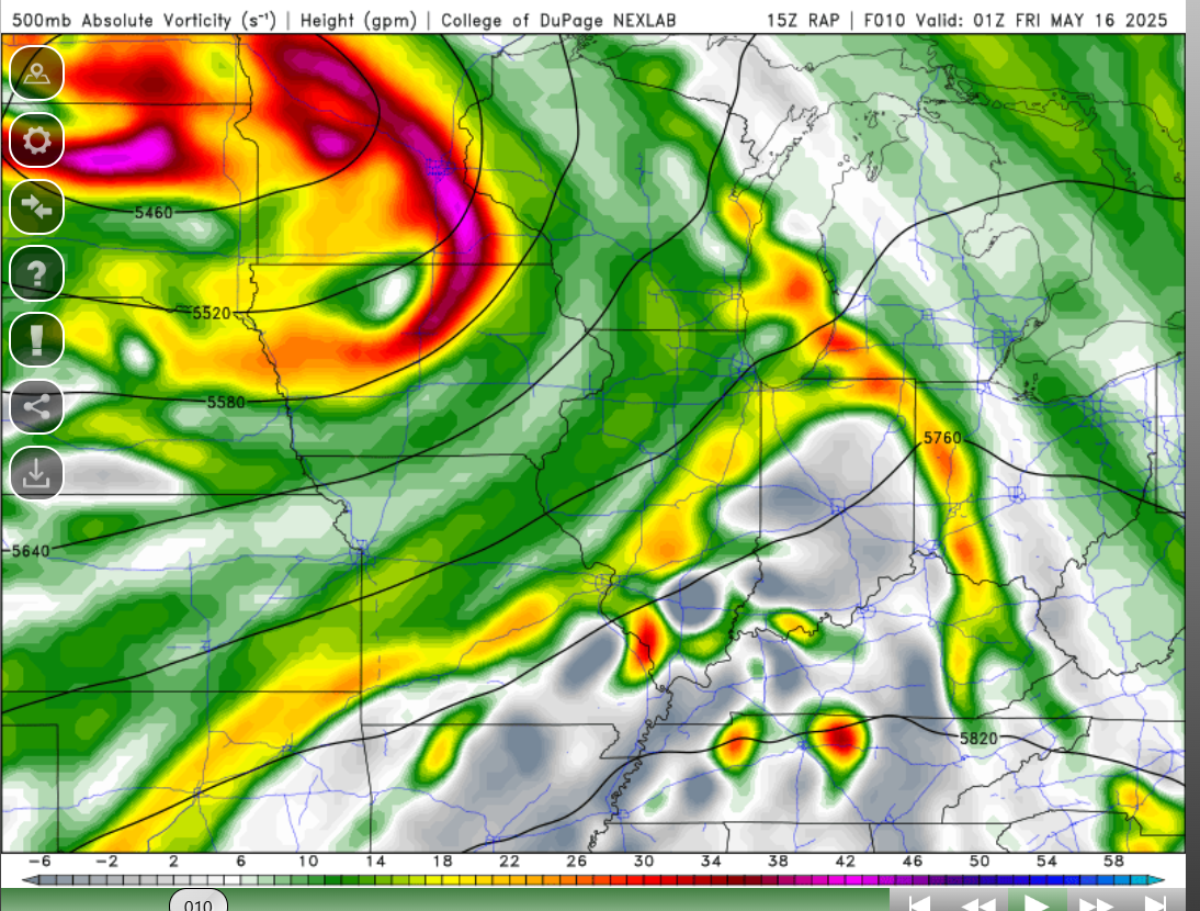
 I wouldnt be suprised to see a storm develop along the indiana/oh border. cap seems to erode as the day goes on as an arc of 500mb vorticity traverses NE.
-
Watch coming soon - https://www.spc.noaa.gov/products/md/md0788.html Mesoscale Discussion 0788 NWS Storm Prediction Center Norman OK 0123 PM CDT Thu May 15 2025 Areas affected...portions of eastern West Virginia and much of Virginia Concerning...Severe potential...Watch possible Valid 151823Z - 152000Z Probability of Watch Issuance...60 percent SUMMARY...The severe threat should increase over the next few hours. Multicells and supercells will be the primary storm mode, with severe wind and hail the main threats. A few instances of 2+ inch diameter hail are possible. A Severe Thunderstorm Watch will eventually be needed. DISCUSSION...Satellite imagery shows agitated cumulus along the WV/VA border, driven primarily by boundary layer destabilization, along with orographic lift associated with the Appalachians. Surface temperatures have already warmed into the mid to upper 70s F to the immediate lee of the Appalachians, where upper 60s F dewpoints, beneath the eastward extent of an EML plume, supports 1500+ J/kg MLCAPE. The 17Z RNK observed sounding shows 8 C/km 700-500 mb lapse rates and the freezing level around 600 mb, beneath where most of the CAPE resides, along with modestly elongated hodographs. Such conditions support supercells capable of severe gusts and large hail, including a few instances of 2+ inch in diameter stones. Given a gradually increasing severe threat, a Severe Thunderstorm Watch will eventually be needed. ..Squitieri/Mosier.. 05/15/2025 ...Please see www.spc.noaa.gov for graphic product... ATTN...WFO...AKQ...LWX...RNK...RLX... LAT...LON 36608017 36768076 37298113 37938092 38388044 38797971 38967837 38617777 37937732 37257730 36797770 36637848 36608017 MOST PROBABLE PEAK TORNADO INTENSITY...UP TO 95 MPH MOST PROBABLE PEAK WIND GUST...55-70 MPH MOST PROBABLE PEAK HAIL SIZE...1.50-2.50 IN
-
Ready to see my social media flooded with those weirdo Chicago tornado sirens.
-
The 12z runs of the NSSL-MPAS triplets all have a robust MCS/line coming through Fri night into Sat AM.
- 528 replies
-
- 1
-
-
- severe
- thunderstorms
- (and 2 more)
-
This sticky stuff is far worse. I could see a return to a drier pattern with sulfate particle release into the atmosphere-- that's what the climate models predict would happen anyway, cooler and drier. But cooler and drier doesn't mean it won't return to higher high temperatures in summer like we had in the 40s, 50s, 60s, and 90s.