All Activity
- Past hour
-

2026-2027 Strong/Super El Nino
40/70 Benchmark replied to Stormchaserchuck1's topic in Weather Forecasting and Discussion
Am I sold on a torch? No, but it's very possible. -
2026-2027 Strong/Super El Nino
40/70 Benchmark replied to Stormchaserchuck1's topic in Weather Forecasting and Discussion
No, I wouldn't. Did you see my May blog? -
warmer days ahead
-

2026-2027 Strong/Super El Nino
snowman19 replied to Stormchaserchuck1's topic in Weather Forecasting and Discussion
And if I dared to post a torch winter run in this dedicated ENSO thread you would be on me like white on rice -
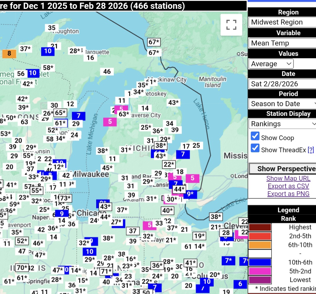
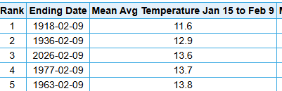
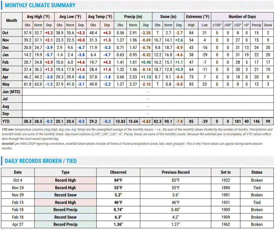
I know everyone already knows this, but TCC and twitter/x handler TheGlobalWarmer are the same person, so in addition to always quoting/replying to his own posts, TCC is now embedding his own TGW tweets. Detroit got a special shout out because I corrected the BS of a normal winter with transient cool shots by posting the actual mean temp maps showing it was a cold winter in the east. This year has been unusual in many areas due to the large diurnal swings. This is why TCC has suddenly abandoned actual avg/mean temps for max temps only. Due to the very warm Mar/Apr, the year is still running above avg to date, despite the fact that Mar/Apr are the only warmer than avg months since October. Detroits avg max temp year to date of 50.2F ranks 19th warmest....but the avg min temp of 31.1F is tied with 6 other years for 59th warmest. Thus, the actual mean temp is 30th warmest to date, tied with 3 other years. It stuck in the craw of the heatmisers that it was an unexpectedly cold winter in the Lakes/east, so theres plenty of excess energy to burn after a warm spring. With the record warmth out west, it was seen as criminal that people in the east were discussing the cold winter where they lived rather than the warm west where they didnt live. And again, no one was acting like this was some record cold winter...it was just a consistently cold, white winter, esp from MI eastward, despite the fact that some tried to paint it as normal. Jan 15-Feb 9th was the 3rd coldest on record at Detroit. Extend that out 4 days to a full month-period (intra month, a stat we have seen posted here many, MANY times wrt warmth), it was the 11th coldest 30-day period on record for Detroit Jan 11-Feb 9th. Quite a transient cool shot! Dec-Jan combined ranked 36th coldest out of 153 years, although the actual avg min temp during this timeframe ranked 26th coldest out of 153 years. The entire winter 2025-26, with a mild 2nd half of Feb, ranked 44th coldest out of 153 years, but the avg min temp for DJF ranked 31st coldest out of 153 years.

-
 June DCA: 0.0 102 NYC: 0.0 98 BOS: 0.0 99 ORD: +2.0 99 ATL: +1.5 99 IAH: +3.0 104 DEN: +2.0 101 PHX: +1.0 119 SEA: +2.0 95
 -
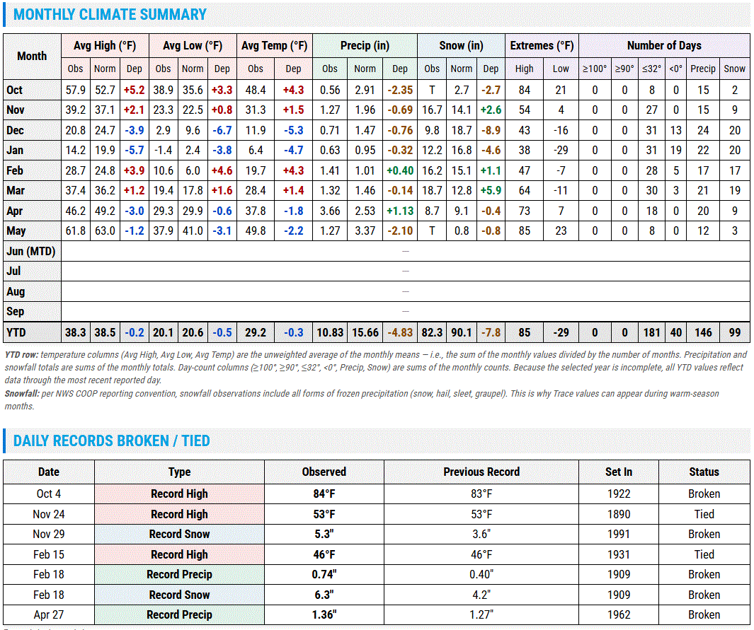
This is a better summary for DLH starting with the beginning of the water year. Rollercoaster temps, and generally dry. Forgot about this section under the climate n past wx page.
-
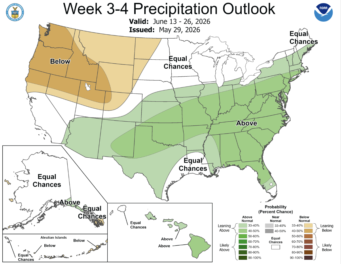
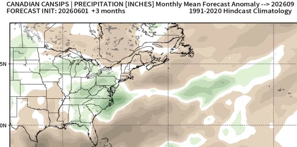
 Cansips has it turning wet, though that's a seasonal forecast.
 -
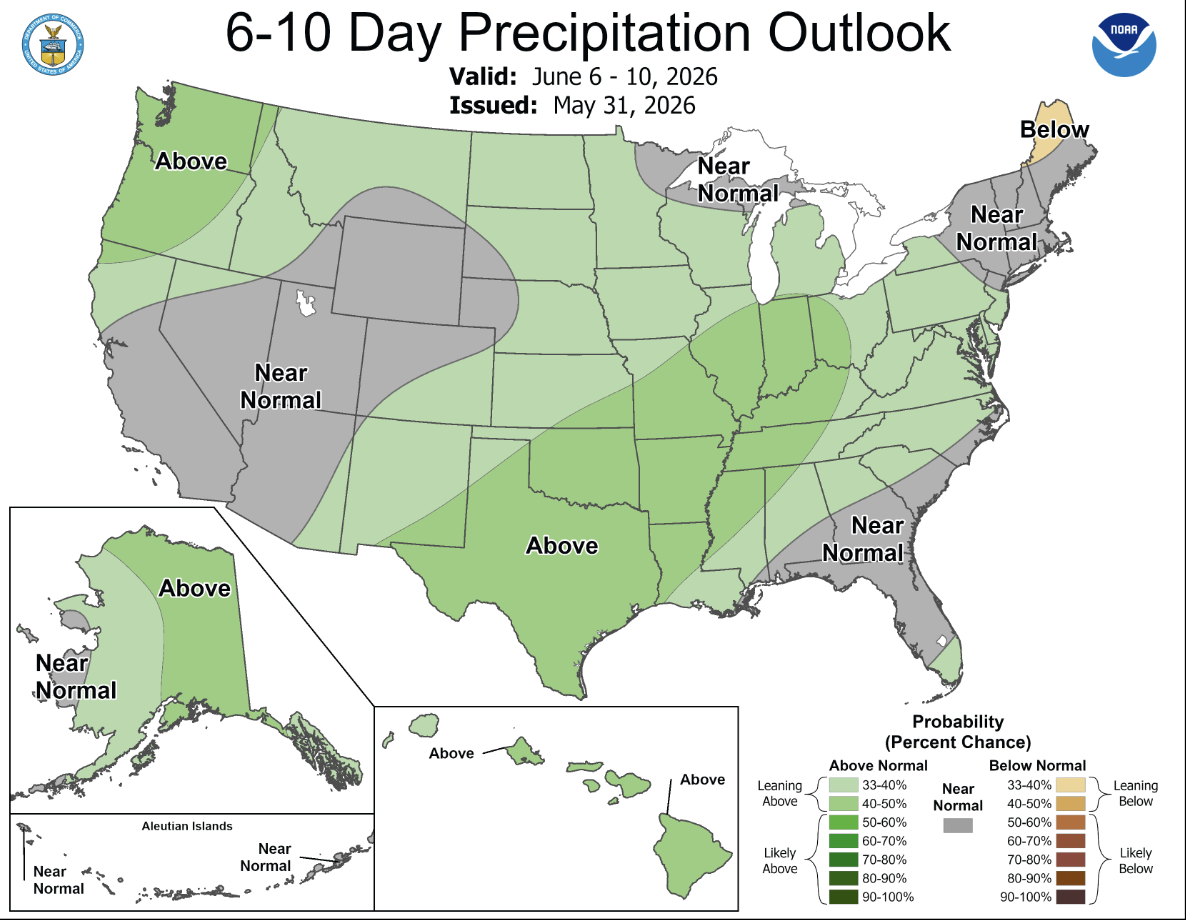
 Have any of these stupid precip outlooks actually verified when they show above normal precip this year? Has NOAA hired Bastardi for their precip forecasting? I'm still holding to my late June derecho and trend toward wet weather. It's still too early.
 -
2026-2027 Strong/Super El Nino
40/70 Benchmark replied to Stormchaserchuck1's topic in Weather Forecasting and Discussion
Kind of looks like last winter with a STJ added. Interesting. -
2026-2027 Strong/Super El Nino
40/70 Benchmark replied to Stormchaserchuck1's topic in Weather Forecasting and Discussion
-
May 2026 at DCA tied for the 60th warmest in DC history with an average temperature of 65.8 degrees -- 1.4 below the 1991-2020 normal. January-May 2026 averaged 50.2, the 27th warmest first five months in DC history. May 2026 precipitation at DCA totaled 2.85 inches, 1.09 below the 1991-2020 May normal of 3.94. For the first five months of 2026, DCA precipitation totaled 12.03 inches, 4.10 below the 1991-2020 normal of 16.13.
-
May finished as the 5th colder than avg month of the past 7. However, due to the extreme nature of the Mar/Apr warmth, the year-to-date is still running warmer than avg. Nov: -0.4 Dec: -3.6 Jan: -5.2 Feb: -0.2 Mar: +4.9 Apr: +4.2 May: -1.6
-

2026-2027 Strong/Super El Nino
mitchnick replied to Stormchaserchuck1's topic in Weather Forecasting and Discussion
It hasn't happened yet! It's a forecast. Eps were too warm with the end of May forecast, soooo.... -
There is definitely some hope on the horizon. The pattern switches to wetter Friday. It feels like an eternity since we've had a thunderstorm.
-
Clearing out a bit, 54.1° Shouldn't feel too bad by afternoon if we can keep the sun
-
New month. Post them here.
-
CLE finished May -3.2 degrees. Back to back mornings IMBY with a low of 43. No complaints though as the weather has been beautiful in the afternoons over the past week.
- Today
-
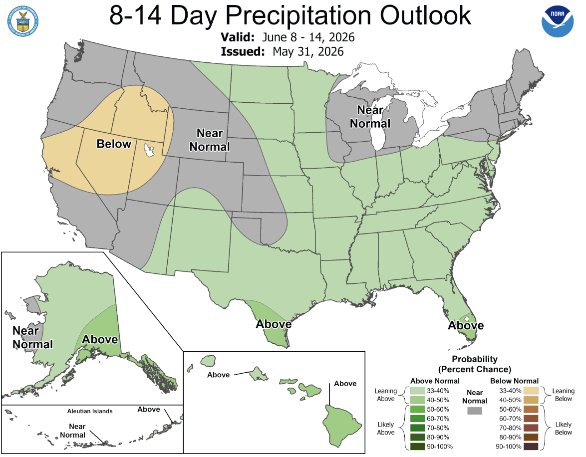
Cansips has it too
-
 Need one of these AN precip outlooks to actually verify. We still seem to be in a long term pattern where dry NW flow wins at shorter leads.
 -
Usually my favorite time of year. Sunny mild days before the real heat and humidity arrive
-
Strange anomalies across the region for May. BOS was 2.4 and HFD was -0.6.
-
That is the Wake County motto ever since the dry slot.
-
Tied for my 3rd warmest spring to go along with the 4th driest.. Last below normal spring was back in 2018.