All Activity
- Past hour
-
No
-

January 2026 regional war/obs/disco thread
Snowedin replied to Baroclinic Zone's topic in New England
Sounds like the plot to the day after tomorrow. Who knows what madness the future holds! -

Ice Ice Baby December 28-29 Storm Discussion
Chrisrotary12 replied to Baroclinic Zone's topic in New England
I don’t know what we’re gusting to right now but OMG. Reminder to self to check data for 3am. -
All gone here on the coast. Today should’ve been Christmas with the low fog and rapidly receding snow. It certainly looked and felt the part!
- Today
-
Snowing nicely all night. We were ripping for a while.
-

January 2026 Medium/Long Range Discussion
Stormchaserchuck1 replied to snowfan's topic in Mid Atlantic
The start of an arctic pattern if it verifies -

E PA/NJ/DE Winter 2025-26 Obs/Discussion
LVblizzard replied to LVblizzard's topic in Philadelphia Region
I’ve never seen a storm as consistently modeled as January 2016. Aside from the 2 days of runs which suppressed the best snow south of Philly, the models were completely locked in on a huge snowstorm for a week and a half. I remember looking at a Euro ensemble run 10 days out with a big storm - which is wild to see on an ensemble mean that far out - and just knowing we’d have lots of long days and nights of tracking ahead. And then by day 7 every model run showed this monster storm crawling up the coast. I can’t remember any other storms that showed up day after day for so long like that. -
E PA/NJ/DE Winter 2025-26 Obs/Discussion
LVblizzard replied to LVblizzard's topic in Philadelphia Region
Some parts of Allentown and Bethlehem just picked up a coating from a lake effect streamer. -

Pittsburgh/Western PA WINTER ‘25/‘26
colonel717 replied to Burghblizz's topic in Upstate New York/Pennsylvania
I'm just down Clifton across from the church. Very heavy right now. -

Pittsburgh/Western PA WINTER ‘25/‘26
blackngoldrules replied to Burghblizz's topic in Upstate New York/Pennsylvania
Yeah, I am actually. I'm about to go outside and get a better look. Hard to tell from my window. It's coming down hard right now. Sent from my SM-S931U using Tapatalk -
Pittsburgh/Western PA WINTER ‘25/‘26
colonel717 replied to Burghblizz's topic in Upstate New York/Pennsylvania
You are right near me. Aren't you near Als Cafe? -
Pittsburgh/Western PA WINTER ‘25/‘26
colonel717 replied to Burghblizz's topic in Upstate New York/Pennsylvania
There is a death band north of city, then this huge one from Steubenville thru Wash Co.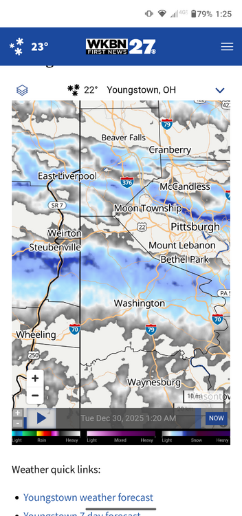
-
Pittsburgh/Western PA WINTER ‘25/‘26
blackngoldrules replied to Burghblizz's topic in Upstate New York/Pennsylvania
Yeah, I may have a couple inches now where I'm at just eyeballing it right now. Even my NWS forecast was "chance of snow" and "less than a half inch". Sometimes you can get lucky in these bands and get hit pretty good. Sent from my SM-S931U using Tapatalk -
22 with a stiff wind from the south, and snow blowing in sideways.
-
Pittsburgh/Western PA WINTER ‘25/‘26
colonel717 replied to Burghblizz's topic in Upstate New York/Pennsylvania
These bands tonight mean business. Can't believe the news stations tonight were saying, snow won't be an issue. If things go well overnight I think I could hit 4 inches. -
 (version 2, Dec 2025 scores _ max 60 scoring adjustments) <<< Max 60 applied to IAH, DEN, PHX scores only >>> For contest integrity, eleven regular forecasters are scored 0 to 60 with 11 intervals ... levels can be boosted by as much as 4 to reduce steps to closest approximation to raw score differentials. Mercurial, Normal, Consensus and Persistence scores are then calculated from comparison to the regular-contestant-generated scores. Scores altered by max-60 calculations have this symbol ^ ... scores without the symbol were either higher raw scores or zero scores unchanged. Most IAH scores are not boosted as raw scores were higher than the progression. This could change if IAH anomaly is higher than my projected +4.0F. FORECASTER _____________ DCA_NYC_BOS _ east _ ORD_ATL_IAH _ cent _ c/e_ DEN_PHX_SEA_west_TOT Mercurial ______________________ 00 _ 00 _ 00 _000 _ 30 _ 80_ 66^_ 176 _176_ 05^_ 00 _ 00 _005__ 181 hudsonvalley21 ________________ 00 _ 00 _ 00 _000 _ 52 _ 96_ 50 _ 198 _198_ 16^_ 46^_ 24 _086__ 284 Scotty Lightning _______________ 00 _ 00 _ 00 _000 _ 40 _ 80_ 40_ 160 _160_ 34^_ 22^_ 40 _096__ 256 ____ Normal ____________________00 _ 00 _ 00 _000 _ 20 _ 70_ 20 _ 110 _110__ 16^_ 06^_ 30 _052__ 162 wxallannj ______________________ 20 _ 22 _ 26 _068 _ 34 _ 86_ 60^_180 _248 _ 60^_ 60^_ 80 _200__448 DonSutherland1 ________________20 _ 40 _ 40 _100 _ 86 _ 80_ 54^_220 _320 _ 54^_ 28^_ 32 _114 __ 434 BKViking _______________________24 _ 26 _ 34 _084 _ 54 _ 88_ 44 _186 _270 _ 52^_ 60^_ 60 _172 __ 442 ___ Consensus ________________26 _ 34 _ 36 _ 096 _76 _ 86_ 42 _204 _300_ 34^_ 40^_ 40 _114__414 so_whats_happening __________ 28 _ 26 _ 32 _084 _ 72 _ 86_ 44 _202 _286 _40^_ 52^_ 42 _134__ 420 Tom ____________________________38 _ 54 _ 56 _148 _ 98 _ 52 _ 30 _180 _ 328 _ 22^_ 40^_ 52 _114__ 442 RJay ___________________________ 40 _ 40 _ 40 _120 _ 80 _ 94_ 30 _204_ 324_ 34^_ 40^_ 40 _114__ 438 RodneyS _______________________ 72 _ 60 _ 46 _178 _ 86 _ 20_ 38 _126 _ 304 _ 52^_ 10^_ 40 _102__ 406 Roger Smith ____________________ 80 _ 76 _ 90_ 246_ 62_ 04_ 00 _066 _312 _ 00 _ 00 _ 00 _000__ 312 wxdude64 ______________________88 _ 62 _ 66 _ 216 _ 86 _ 20 _06 _112 _328_ 06^_ 16^_ 76 _098__ 426 ----------------- (highest and lowest forecasts above are color coded; all forecasts are below normal for ORD) __ Persistence ___(Nov 2025)___ 00 _ 16 _ 10 _026 _ 00 _ 60 _78^_ 138 _164_ 80^_ 80^_ 72 _232 __396
 -
GFS continues to rain on the sustained cold parade. It is finding new and creative ways to destroy the block And now the Euro looks more like the bad GFS runs.
-
What is extraordinary is my hourlies from WUN show snow falling every hour til 2pm on Jan 1!! A hour won't go by without flakes for the rest of the year...
-
I’m down with running back January 3rd of last year. Sorta funny how that squall kicked off an active period too!
-
Let's not forget it's the GooFuS.
-
It’s a goddamn shame.
-
I'm all for it, but I think to get meaningful cold in the SE that AK trough needs to exit stage left
-

January 2026 regional war/obs/disco thread
WinterWolf replied to Baroclinic Zone's topic in New England
I wonder if 0z Euro doubles down? Maybe we(SNE) win if they both can give us a nice big coastal from entirely different patterns…. -

January 2026 regional war/obs/disco thread
vortex95 replied to Baroclinic Zone's topic in New England
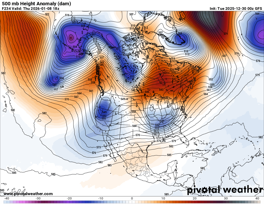
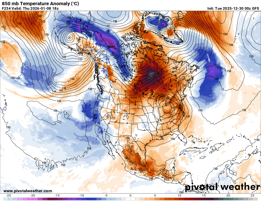
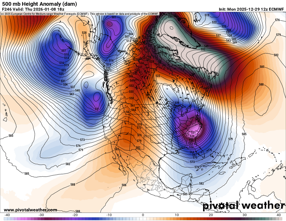
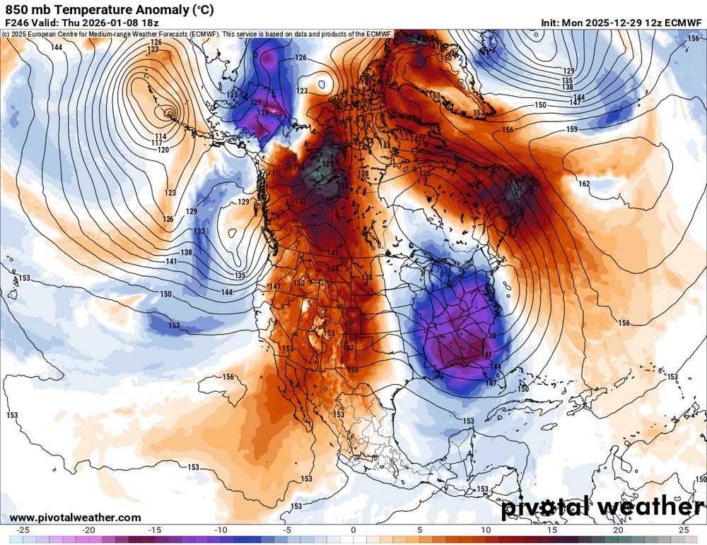
I know we are dealing w/ 10 days out, but the difference between the GFS and ECMWF op is immense. I attached the 30/00z GFS and the 29/12z ECMWF 500H/850T anomalies VT 18z Jan 8. They could not be any more different. The GFS has split flow w/ no polar jet present, just STJ and 500 heights above 540 all of the CONUS. 850 temps above avg most of the country and a large part of Canada. The ECMWF, OTOH, has a huge polar jet presence merging w/ the STJ and very cold ern US and mild wrn US. In addition, the GFS has little blocking near Greenland, while the ECMWF is through the roof! What's funny is that either of these patterns could give a "CoastalWx Biggie" to the NEUS. GFS pattern suggests more Miller A and ECMWF suggests more Miller B! Odd. Which one will "win?!"

-
The final third of Jan will be rockin'.