All Activity
- Past hour
-
Really windy out this morning
-
SREF way more amped and NW
-

“Cory’s in NYC! Let’s HECS!” Feb. 22-24 Disco
ineedsnow replied to TheSnowman's topic in New England
It's coming! -
Maybe 1 or 2 tonight and another 1 in morning? I think we might have a lot of sleet too.
-

2025-2026 Fall/Winter Mountain Thread
Maggie Valley Steve replied to Buckethead's topic in Southeastern States
Special Weather Statement up for the Mountains with this line of storms. Cold front should push through behind the line as it moves East of the Mountains. -
Yes indeed
-

Feb 22nd/23rd "There's no way..." Storm Thread
mitchnick replied to Maestrobjwa's topic in Mid Atlantic
My NWS forecast is 1-3". Obviously not buying Gfs. -
NWS for central NJ (Mt. Holly) through the Five Boroughs (Upton) is going with a middle ground, 1-2, 1-3 inches, forecast.
-
-

Feb 22nd/23rd "There's no way..." Storm Thread
Terpeast replied to Maestrobjwa's topic in Mid Atlantic
I think we should be rooting for a later start time either way. Get the clouds here during the day to hold off the sun angle, and then thump overnight for best snow-maxing -

“Cory’s in NYC! Let’s HECS!” Feb. 22-24 Disco
The 4 Seasons replied to TheSnowman's topic in New England
being on here for almost 12 years, and seeing from who that post originated, i assure you, it was not -

Feb 22nd/23rd "There's no way..." Storm Thread
WxUSAF replied to Maestrobjwa's topic in Mid Atlantic
I could see a scenario where colder spots like you get a little accumulation early Sunday, then it melts away, and then more with the IVT. -

“Cory’s in NYC! Let’s HECS!” Feb. 22-24 Disco
40/70 Benchmark replied to TheSnowman's topic in New England
Subtle, but you can start to make out the trend of a later closure with a slight LBNE nudge on 06z... I don't like how the EURO doesn't curl it up, though...still kicks east at out latitude. -

“Cory’s in NYC! Let’s HECS!” Feb. 22-24 Disco
codfishsnowman replied to TheSnowman's topic in New England
What happened to the DC blizzard though? -
“Cory’s in NYC! Let’s HECS!” Feb. 22-24 Disco
The 4 Seasons replied to TheSnowman's topic in New England
yeah mostly same, a lot of BM (or hair SE) storms arent great here depending on the trajectory if they cross SW to NE over the BM thats fine like 2013 but if they swing a wide right almost due north/NE over the BM like Jan 15/22 then WOR can be in trouble. Theres obviously a ton of other factors but thats the general idea -
Feb 22nd/23rd "There's no way..." Storm Thread
Imgoinhungry replied to Maestrobjwa's topic in Mid Atlantic
Euro showing 3-5 and gfs 10+. Expected snowfall 1-2 inches? Guess they are factoring in marginal temps and going with a lot less than 10:1? . -

Feb 22nd/23rd "There's no way..." Storm Thread
SomeguyfromTakomaPark replied to Maestrobjwa's topic in Mid Atlantic
Looks more coastal and less IVT. I want to believe!!! -
The best rates look at onset and some of the short term guidance is flagging a loss to rain or white rain before transition to accumulating snow. Another reason to hedge against the 5”+ amounts
-
This has been our driest winter through 2-19 since 2002. Time Series Summary for NEWARK LIBERTY INTL AP, NJ Driest 12-1 to 2-19 periods since 1991 Click column heading to sort ascending, click again to sort descending. 1 2002-02-19 4.28 0 2 2026-02-19 5.60 0 3 1992-02-19 5.79 0 4 2007-02-19 6.44 0 5 2022-02-19 7.02 0 6 2001-02-19 7.04 0 7 2025-02-19 7.66 0 8 2012-02-19 7.71 0 9 2000-02-19 7.83 0 10 2018-02-19 8.20 0 Time Series Summary for NY CITY CENTRAL PARK, NY Driest 12-1 to 2-19 periods since 1991 Click column heading to sort ascending, click again to sort descending. 1 2002-02-19 4.72 0 2 2026-02-19 6.32 0 3 2007-02-19 6.98 0 4 1992-02-19 7.22 0 5 2001-02-19 7.46 0 6 2012-02-19 7.63 0 7 2025-02-19 7.72 0 8 2000-02-19 7.87 0 9 2022-02-19 7.91 0 10 1995-02-19 8.37 0 Time Series Summary for SUSSEX AIRPORT, NJ Driest 12-1 to 2-20 periods since 2000 Click column heading to sort ascending, click again to sort descending. 1 2002-02-19 3.58 0 2 2026-02-19 4.02 0 3 2021-02-19 4.11 8 4 2022-02-19 5.08 0 5 2020-02-19 5.73 2 6 2011-02-19 5.82 0 7 2017-02-19 5.93 0 8 2007-02-19 5.98 0 9 2025-02-19 6.08 2 10 2023-02-19 6.36 2
-
“Cory’s in NYC! Let’s HECS!” Feb. 22-24 Disco
40/70 Benchmark replied to TheSnowman's topic in New England
I narrowly missed the JP in 2015....Death band pivoted a bit beyond me after looking like it would stop around me, but no complaints. Jan 2022 was a disaster I saw coming early in the event...I remember scooter tried talking me off the ledge, but I knew and just went and slept through most of it. -
I will say WBAL this morning must be using the gfs a little bit as they were showing it snowing at my house as early as 5am Sunday. Of course I’ve got elevation which helps with the marginal temps but still gonna be hard to accumulate much unless it’s dumping.
-

Central PA Winter 25/26 Discussion and Obs
mahantango#1 replied to MAG5035's topic in Upstate New York/Pennsylvania
-
I'm hoping he wasn't serious.
-

February 22-23 Storm Thread/OBS
coastal front replied to Mikeymac5306's topic in Philadelphia Region
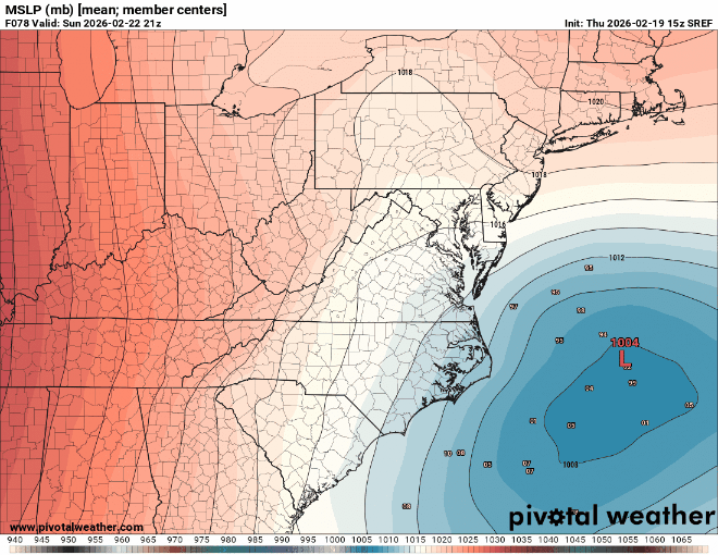
AIFS ensembles showing close to 10” on the coast. Euro ensembles look like a tick west. Good signs for the bigger outcomes we all hope to see -
Radar looking like it starts around 1pm here Earlier than progged start times do happen with these but jeeze…


