All Activity
- Past hour
-
While milder than avg winter is a given (2 colder than avg winters followed by a strong El Nino, no way its not), snowfall and precip remains the wildcard. If I am not mistaken, your area got a lot of snow in 2015-16. That was a crazy year where snowfall ranged from slightly below avg in Detroit to slightly above in the northern burbs to well above in Flint. My first guess for Detroit for 2026-27 is 33". Im taking the middle ground of strong Nino snowfall and will adjust if anything becomes more clear once winter begins.
-

October Comes Early: Late September Multi-Hazard Hybrid Storm
Sey-Mour Snow replied to WxWatcher007's topic in New England
I like to compare 12z to 00z, Gfs is a good bit east of 00z and less impactful, but well west of the 6z east outlier. All options still on the table. -

Central PA Summer 2026 Discussion/Obs Thread
mahantango#1 replied to Voyager's topic in Upstate New York/Pennsylvania
Someone needs to start the fall thread. It is fall after all. Where are all our pumpkin spice lovers at? -

Winter 2026-2027 Seasonal Outlook
WinstonSalemArlington replied to WinstonSalemArlington's topic in Southeastern States
Hmmm, that is interesting. I‘M using a pic hosting site that seems to work otherwise. -
Did we not work out something with Mexico with regard to potential threats? Granted, Polo likely avoids landfall, but it will pass close enough to cause problems (i.e. flooding). Not sure but it makes sense to just go ahead and do a mission for training and research purposes in a dead quiet hurricane season.
-
Yes I am looking forward to that. Ninas arent always perfect, but they usually bring a good winter here.
-

October Comes Early: Late September Multi-Hazard Hybrid Storm
WxWatcher007 replied to WxWatcher007's topic in New England
Eastern SNE gets hit good up to Maine. Not much elsewhere. But it is further west from earlier runs. -
Hardywood in Goochland ran out of Oktoberfest on Saturday so I tried their Farmhouse Pumpkin and it was excellent. Highly recommend.
-

2026-2027 Record-breaking El Nino
LakePaste25 replied to Stormchaserchuck1's topic in Weather Forecasting and Discussion
I imagine this will go back up. RONI is already at +2.5 and while I am aware this is a daily index compared to a 3 month mean, it is only September and we likely have 2-3 more months until the peak. I am thinking the 3 month mean will be closer to 3-3.3 -
It's unfortunate. WB will never correct the algorithms.
-

October Comes Early: Late September Multi-Hazard Hybrid Storm
ineedsnow replied to WxWatcher007's topic in New England
12z GFS starting to get a clue but not there yet -

2026 Atlantic Hurricane Season
Windspeed replied to Stormchaserchuck1's topic in Tropical Headquarters
See my edit. I'm not upset at all. I just need to be clear. -

October Comes Early: Late September Multi-Hazard Hybrid Storm
Brian5671 replied to WxWatcher007's topic in New England
GFS correcting west now -
this is a stronger and even more east based event than 1998 and we have 30 years of warming on top of our base state
-
Just light, off and on showers since about sunrise here, but still adding up. Around 1.35” since Sunday morning.
-

2026 Atlantic Hurricane Season
vortex95 replied to Stormchaserchuck1's topic in Tropical Headquarters
I hope you are not upset. Debate/discussion is what science is all about, so talking about this all is not a counterproductive notion. I was talking in general as how things are not always done by meteorological standards only and there are many external factors out there. That's not a conspiracy, that's just how society is, and not unique to the wx field. I don't know specific reason(s) why Sandy called what is was at landfall, but something doesn't jibe w/ empirical observations and standard/practices done w/ many other TCs in the similar state of transition, and it is not just me who have questioned things. And we are talking about what it is called (tropical or not), not specific reasons why, and just that it is not always objective or supports the evidence. You wrote: "Whatever their reasons in 1991 for a large hybrid system that gains an inner symmetrical tropical surface low." Sandy was very similar to this. It was a large hybrid system once it got to the Bahamas, then then on the day of landfall, and inner symmetrical tropical sfc low developed. So I go back to the consistency of standard/practices here. As I have said, we've seen many times NHC keep a TC tropical when it clearly not anymore, or declare something that does not fit the definition of a TC, but it is close to land. Whether it is close to land or not should be irrelevant. I mentioned this w/ Fay, when another noted they seemed to delay calling it even a TD when it was likely it was since it was no threat to land. Semantics do count. What something is called officially or not has significant impact, such as in the legal profession. And exact details/meanings count in the sciences. An ET low and TC has a number of similarities, but also sig differences. Same thing for a mesocyclonic tornado and landspout. And they way things are, what something is called or not does matter outside the met sciences in the social/economic/political realms and their influences are there. -
I’ll be up late waiting for my 4+” of precip
-
Hard to beleive, I know. Reminds me of the old days in my youth when we used to get storms out here.
-
1" on the dot up here. Feels and looks like Fall on the first day of Fall. Hopefully the first day of Winter delivers similarly...to Winter that is!
-
Septorcher 2026 Discussion - Endless Summer
ineedsnow replied to Damage In Tolland's topic in New England
I've been mentioning this for days.. its been showing up on some of the ensemble members -
Bad miss down here too. My only measurable rain was an hour shower 5-6pm yesterday. Nothing since. Next couple days look more promising but being wedged in will keep a lid on anything convective. 2-3" is prob off the table. Lakes remain thirsty and very low
-

Septorcher 2026 Discussion - Endless Summer
kdxken replied to Damage In Tolland's topic in New England
Phone has been ringing off the hook this morning for firewood. Folks thinking to themselves in another three or four months this could be a cold rain. -
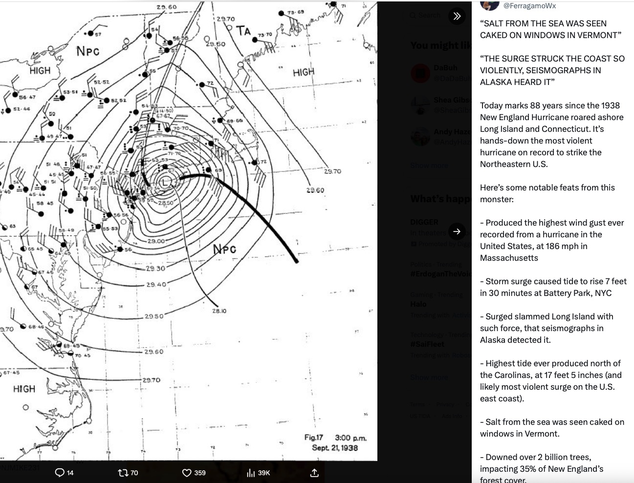
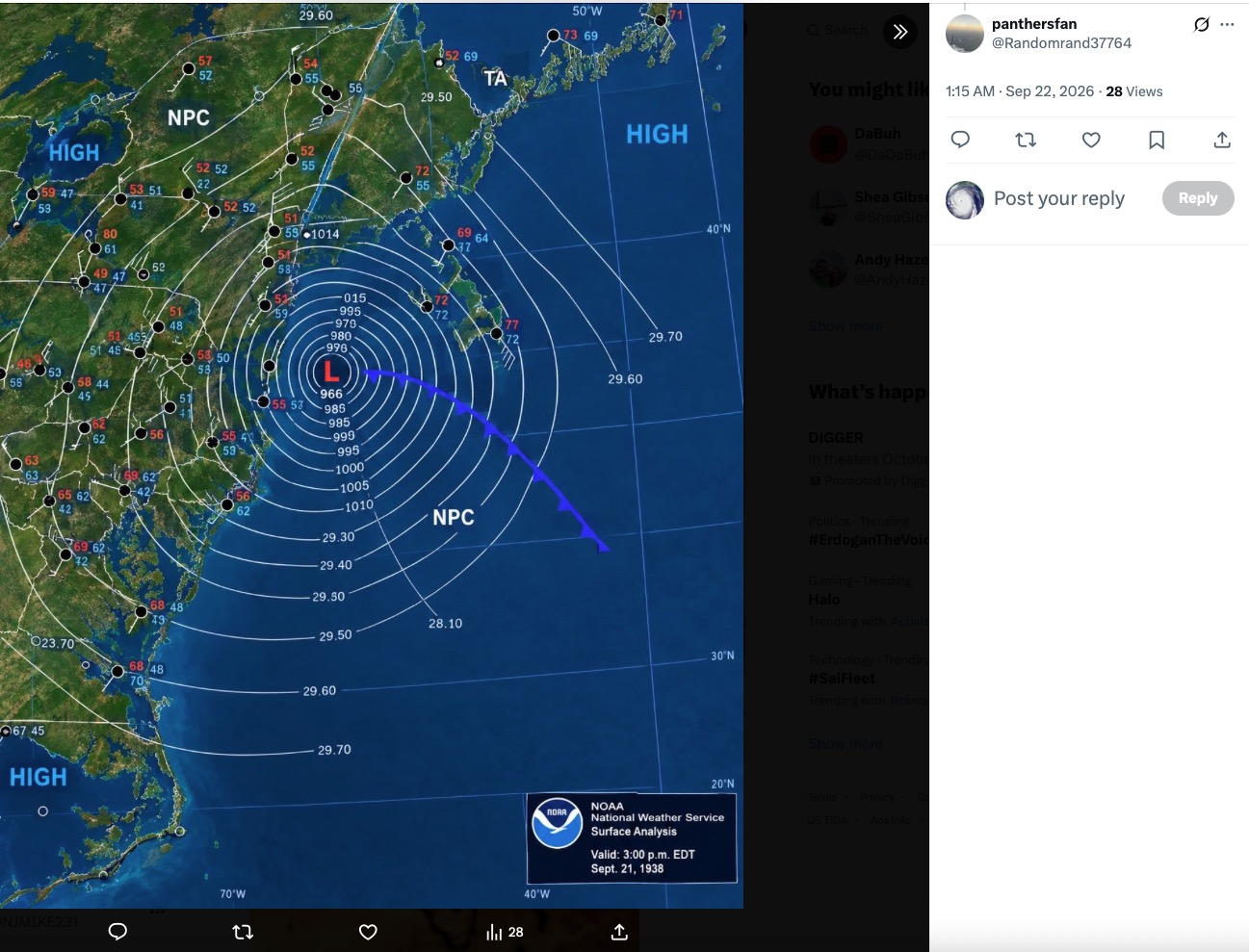
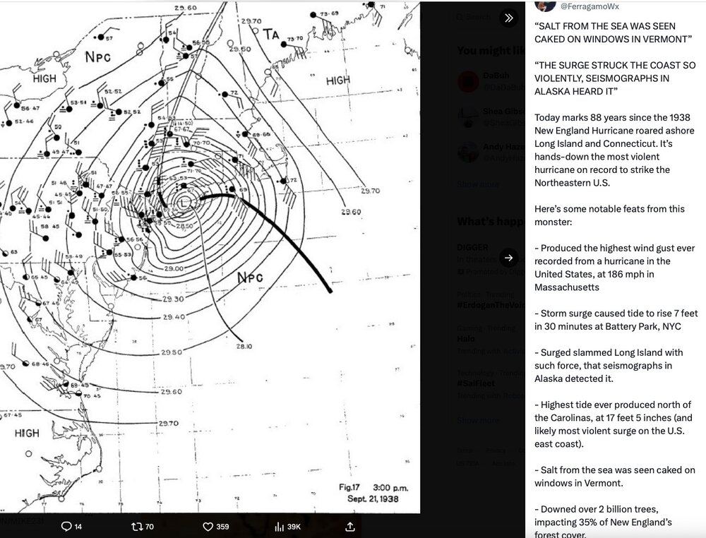
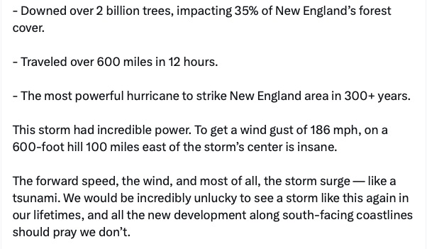
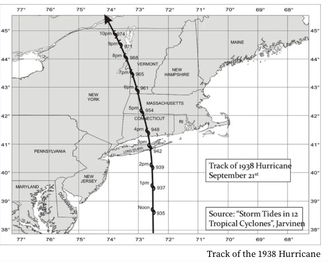
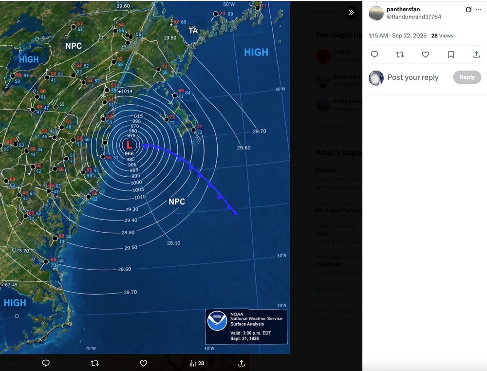
It was 88 years ago yesterday. Can't even imagine if something similar today. Rapid forward speed was unprecedented and aided in keeping intensity up, piling up surge and making the eastern semi-circle truly violent well inland into New England. L.I. landfall pressure was on par with Sandy in NJ. Other big hurricanes followed 1938 affecting the Mid-Atlantic and Northeast (1944, Hazel, Donna, Carol, Bob) but 1938 was in a class by itself. As far as population impacts and damage (wind and surge) I'd have to say Sandy comes in second.
-

Septorcher 2026 Discussion - Endless Summer
Hoth replied to Damage In Tolland's topic in New England
I see you’re limbering up for winter already. Preemptive congrats on the Jack. -
October Comes Early: Late September Multi-Hazard Hybrid Storm
ineedsnow replied to WxWatcher007's topic in New England
Full moon Saturday should make coastal flooding worse