All Activity
- Past hour
-

Central PA Winter 25/26 Discussion and Obs
Itstrainingtime replied to MAG5035's topic in Upstate New York/Pennsylvania
Thank you for that. Life is full of opportunities to grow. I try and learn from mistakes and be better in life because of them. My journey continues (literally and figuratively right now) and I will continue to strive to be a better poster, but more importantly...just a better human being. And in my line of work, that is one thing that stands out to me - our culture today has lost the value of treating others well. -
NAM following the CMC. .
-
Thats the Weathernext 2.0 Model I think. https://efisher828.github.io/weathernext/
-
Lock it up. By the way, how much for Philly?
-
 Looking ahead looks like a great stretch of great winter weather, like I remember from the 60s as a kid.
 -
The GFS will still be terrible.
-

January 25-26th, 2026 Final Storm Totals
FlashFreeze replied to The 4 Seasons's topic in New England
Been out plowing all day in Hartland Granby and Canton and North Granby had the most at 20 inches with North Canton and Hartland at 18” there was a slight coating of freezing rain from sometime overnight in Hartland this morning. -
Ji was doomposting on Eastern before you were even born.
-
Looks like Norfolk's largest snowstorm on record is Dec 27-28, 1892 with 18.6 inches. This storm could theoretically surpass this based on some model runs today. I can't locate upper air or surface maps for this storm - any idea if there are any available? Would all be estimates, obviously, but curious how that storm played out and what happened up here, if anything.
-
Speaking of Rutgers, the university closed for the first time in its long history for the Febuary 5, 1978 storm. I was a student at Cook College then.
-
 just made my last measurement - not really expecting anything additional. Picked up 4.2" since this morning... that last band crushed. My last 3.6" came on 0.12" SWE - 30:1 !! Storm total: 21.4", LFG! Top 5 for me personally. 1.88" SWE for the event. JUICED
 -

January 2026 Medium/Long Range Discussion
SomeguyfromTakomaPark replied to snowfan's topic in Mid Atlantic
Anyone know if we can access this new Google ensemble model? -
We will have handheld phones like those by about 2037, they will use applied nanotechnology to change shape, but we will have even better tech than phones by the middle/later 2030s.
-
Yeah, watching it too. Definitely stretched more wester so far vs 18z
-
 What is this beast All PVA from H5 vort rounding trough?
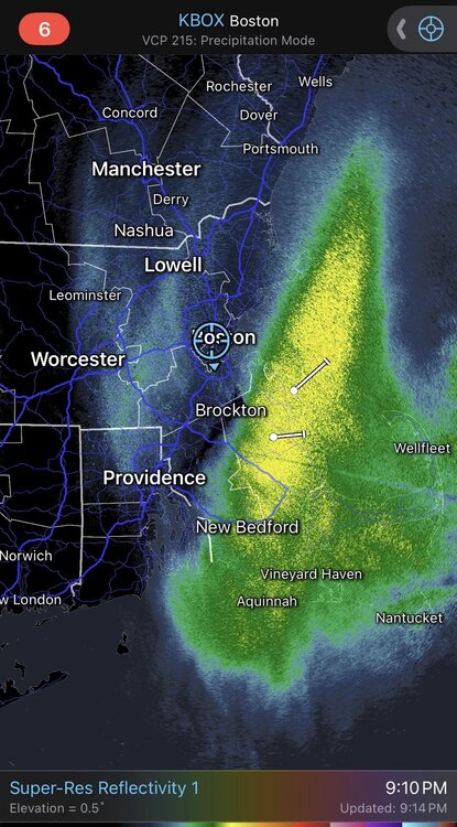
-
nam with QUITE the jump west of our NS energy by hour 48. significantly more stretching of the TPV and looks more conducive to break off. hope that's something with 00z models and not just the nam being the nam
-
 3.2” of fluff since 5 pm
 -
 Picked up an additional 2.25” tonight.
 -
 Can confirm. This band is the heaviest snowfall of the storm. Simply because the snow growth is 10/10
 -
 It’s actually snowing pretty decent in this band back by 495….vis dropped quite a bit…but man, that PYM band
-
Wonder if we’ll see the back bays here frozen over. Probably given the duration of the cold and that every night should be in the teens and single digits some nights.
-
16.8'' for an 830pm report out of west hartford vt, 20 minutes from me. I think I'm a little under that, estimating roughly 15'' or so.
-
Ok, 3 things going on here: 1) The winter suite in the NBM is only updated at 01, 07, 13, and 19Z. So, if you're showing an 18Z cycle for this medium range case, it's as "stale" as you can have it. 2) In the medium range, the only inputs are the 50 ECMWF ensemble members, the 30 GEFS members, and the GFS. It doesn't even include the deterministic ECMWF run (don't ask). Some of the CMC members are now included in the parallel. Here is what you're going to hate: the NBM does not yet receive the 06/18Z ECWMF data. And at 19Z, the ECMWF ensemble has not yet arrived. So, the 18z cycle in question is still using the very snowy 00Z ECMWF ensemble. That's what's driving the big numbers. 3) One additional factor: bias correction is performed for QPF for the global model inputs, and the bias-corrected QPF is used by the NBM winter suite. The bias correction, based on the based 90 days of forecasted and observed QPF in this case is bumping up the QPF for the event, as it believes that the ECMWF ensemble has been running dry. So, you have some inputs with high raw precip values that are being further adjusted up. That's why the 18Z NBM looks so snowy. The 01Z cycle coming out soon will use the 12Z ECMWF ensemble and the 18Z GEFS; based on what I see in the QPF of those systems, my guess is the NBM snowfall will be a fair amount lower, although the bias correction might boost it a bit more than I expect.


