All Activity
- Past hour
-

2026 Mid-Atlantic Severe Storm General Discussion
EastCoast NPZ replied to Kmlwx's topic in Mid Atlantic
Every. Single. Time. -

2026 Mid-Atlantic Severe Storm General Discussion
dailylurker replied to Kmlwx's topic in Mid Atlantic
I'm watching it on radar. Unbelievable. It's dieing and trying to go north lol -
2026 Mid-Atlantic Severe Storm General Discussion
EastCoast NPZ replied to Kmlwx's topic in Mid Atlantic
It's falling apart faster than a Cowboys football season. No match for the rain sheild.- 2,181 replies
-
- 1
-

-
- severe
- thunderstorms
- (and 7 more)
-
October NAO is interestingly inverse to the Winter (DJFM)! It's the only month of the year that has an opposite correlation. October is also the highest month of PDO correlation to US pattern. The Pacific 500mb in October is a big indicator to see which is winning the battle - El Nino vs -PDO! Of course we've had 6 straight months of -PNA, and Aug is looking to come in around 0.0. I mean, if that continues it will be interesting to see what actually happens in the Winter (basic Nino pattern is not a given).
-

Augdewst 2026: Summer's Last Stand
Damage In Tolland replied to Prismshine Productions's topic in New England
Congrats Scooter and Dendy
-
It's all about sun angle! Kills the snow pack this time of the year....lol
-
Idk, i'll take October.
-
It does appear to be heading your way but it's shrinking a bit
-
Im the new Stephens City lol
-
Its headed east... coming for you
-
2026 Mid-Atlantic Severe Storm General Discussion
EastCoast NPZ replied to Kmlwx's topic in Mid Atlantic
Constant thunder. Someone is getting it good. -
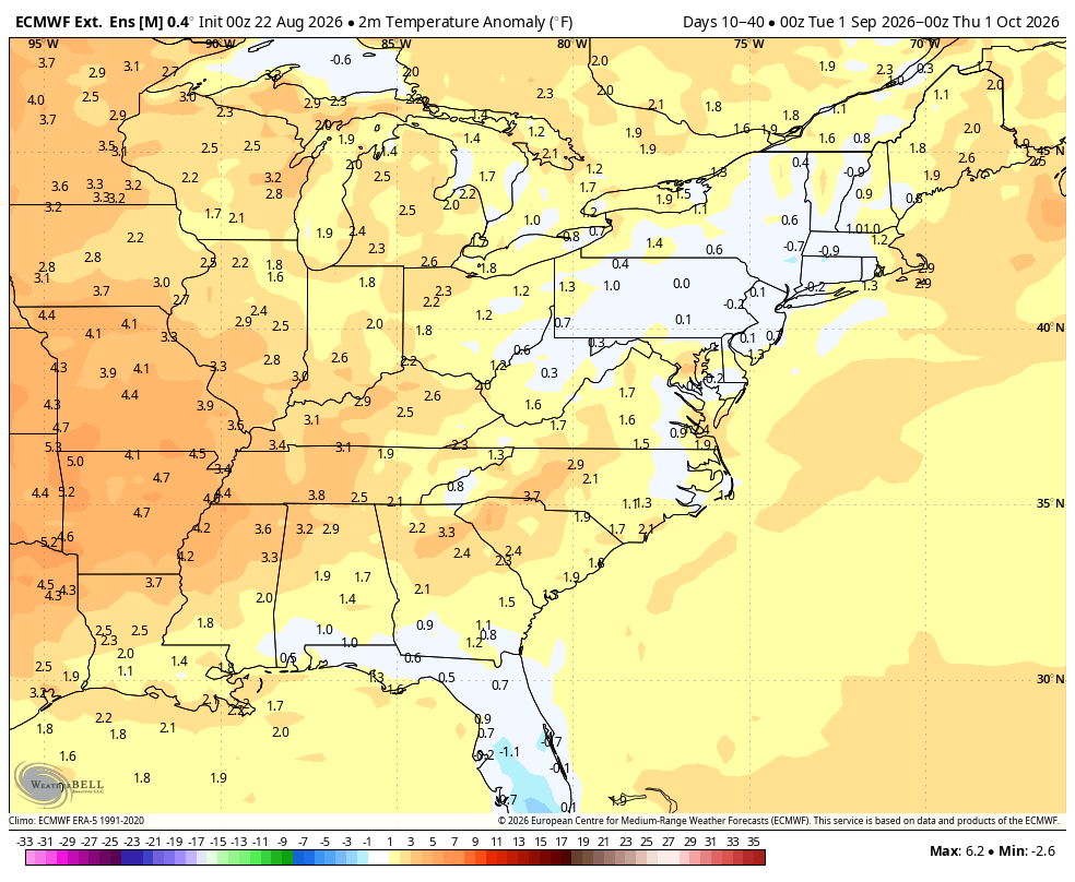
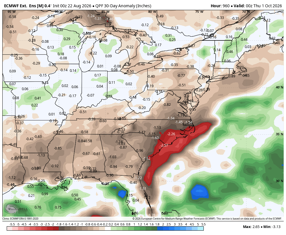
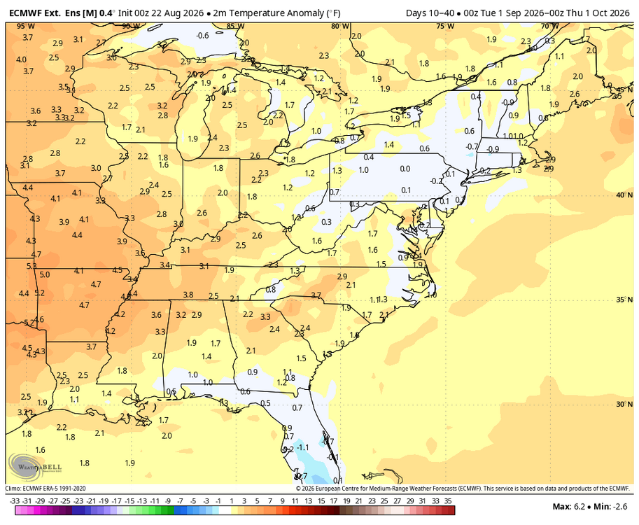
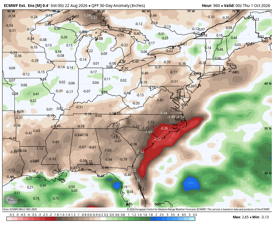
WB latest weeklies: mild and dry September.
-
 buy Viagra over the counter or sildenafil online cheapest viagra http://goldankauf-engelskirchen.de/out.php?link=http://primemensrx.com Viagra online price or http://www.sportchap.ru/user/nvcomgisqg/ buy viagra here [url=http://cse.google.fm/url?q=https://primemensrx.com]cheapest viagra[/url] Viagra online price and [url=https://www.0468wudi.com/home.php?mod=space&uid=258480]order viagra[/url] sildenafil 50 mg price
 -
+4 at SLK is still a very cold winter for 90% of New England lol. Like the minimum temp was 3F instead of -1F.
-
I have this feeling too, and if you think about it, the warmer December is the colder JFM can be and still the winter can average normal to slightly above overall. I am almost ready to root for this as it feels close to a lock anyway.
-
2026 Mid-Atlantic Severe Storm General Discussion
EastCoast NPZ replied to Kmlwx's topic in Mid Atlantic
And miss it will. -
(002).thumb.png.6e3d9d46bca5fe41aab7a74871dd8af8.png)
E PA/NJ/DE Summer 2026 Obs/Discussion
ChescoWx replied to PhiEaglesfan712's topic in Philadelphia Region
Me too! -

Augdewst 2026: Summer's Last Stand
powderfreak replied to Prismshine Productions's topic in New England
Bummer on the snow depth down to 0”. -
Long time, everyone. Looks like the names are mostly the same. I live in Stephens City. We’ll see how it goes I guess. .
-
We just got back from a trip to Portugal, Spain, and the UK. All I can say is they have had a very long, hot, and incredibly dry summer. The leaves in London are all falling from the lack of rain and the grass is all burnt out. When we were in London it was their first "cool" shot of the whole summer, but moisture starved front, so no rain. It felt like October the first night we were there, but looked like it even more with so many leaves on the ground. We did not see one cloud the whole time we were in Portugal and Spain though. Weather was hot hot hot, especially in Spain. Great trip overall though. Really incredible places. Now hopefully we can maybe dry out just a bit...
-
2026 Mid-Atlantic Severe Storm General Discussion
dailylurker replied to Kmlwx's topic in Mid Atlantic
A tornado through Stephen's City would be funny, but not funny at the same time. Hail core headed right for Stephen's City. I can't wait to see how it misses lol- 2,181 replies
-
- 1
-

-
- severe
- thunderstorms
- (and 7 more)
-
Torch!
-
This is actually a good series to go to since we are 5 games away from .500 (the problems don't start until we're 3 games away), and we have randomly owned the Rays for some strange reason this year, lol
-
Looks like its re-intensifying... hail core has reappeared
- Today
-
Mesoscale Discussion 2091 NWS Storm Prediction Center Norman OK 0502 PM CDT Sat Aug 22 2026 Areas affected...Portions of western/central Virginia and northern North Carolina Concerning...Severe potential...Watch possible Valid 222202Z - 230030Z Probability of Watch Issuance...40 percent SUMMARY...Storms are expected to increase in coverage while spreading eastward into this evening. The primary concern is locally damaging wind gusts. While a watch is not currently expected, trends are being monitored. DISCUSSION...Thunderstorms are increasing in coverage along the Blue Ridge in western VA, potentially aided by increasing midlevel height falls preceding a broad midlevel trough approaching the region from the west. Over the next few hours, these storms should continue spreading eastward across western/central VA and northern NC. A warm, moist, and uncapped air mass downstream should support a modest increase in thunderstorm coverage. While midlevel lapse rates are limiting overall buoyancy (around 1000-1500 J/kg MLCAPE), an elongated midlevel hodograph (40 kt of 0-6 km shear per FCX VWP) could promote a few loosely organized clusters capable of producing locally damaging wind gusts. While the overall risk may remain too localized/sparse for a watch, trends are being monitored. ..Weinman/Thompson.. 08/22/2026 ...Please see www.spc.noaa.gov for graphic product... ATTN...WFO...AKQ...LWX...RAH...RNK...GSP... LAT...LON 36568122 36908125 37628037 38057977 38737887 39377837 39447792 39237739 38807712 38207722 36967810 36137933 35987997 36008043 36298116 36568122 MOST PROBABLE PEAK WIND GUST...55-70 MPH MOST PROBABLE PEAK HAIL SIZE...UP TO 1.25 IN