All Activity
- Past hour
-
64 I would think if tonight stays clear and winds light, temperatures in more rural areas will be even chillier.
-
No, it’s not an easy course for sure. Drives have to be spot on.
-
Topped it and it went into hazard. front tees were set up in temporary location, all the way up on left side, took out dogleg completely.
-
The region experienced its coolest lows so far this season overnight. Low temperatures included: Binghamton: 39° Bridgeport: 50° Caldwell: 47° Danbury: 39° Islip: 50° Montgomery: 36° New Haven: 47° New York City-Central Park: 53° New York City-JFK Airport: 52° New York City-LaGuardia Airport: 54° Newark: 52° Poughkeepsie: 36° Sussex: 37° Westhampton: 50° White Plains: 48° Temperatures will quickly moderate tomorrow, rising to above normal levels by the weekend as an air mass that will challenge or break records in parts of the Upper Midwest moves eastward. Already, parts of South Dakota saw highs reach 90° or above. A warm weekend lies ahead. Highs will generally reach the upper 70s to lower 80s. The warm weather will continue early next week. The ENSO Region 1+2 anomaly was -0.1°C and the Region 3.4 anomaly was -0.5°C for the week centered around September 24. For the past six weeks, the ENSO Region 1+2 anomaly has averaged -0.12°C and the ENSO Region 3.4 anomaly has averaged -0.42°C. La Niña conditions will likely develop during mid- or late-autumn. The SOI was +15.60 today. The preliminary Arctic Oscillation (AO) was -0.011 today.
-
Thanks guys. I'm sure you're right. I know the soybeans are being harvested, but still quite a few corn fields around here that's still pretty green, but drying rapidly.
-
Bullshit
-
Days like today is why October is our best weather month outside the occasional snowy winter month.
-

Spooky Season (October Disco Thread)
dendrite replied to Prismshine Productions's topic in New England
lol -
No chance their just parroting what's meme-popularized in the razor sharp cutting scientific insight and intuitively gifted social mediasphere, either, huh
-
I was just listening to the radio and they were talking about winter and they said that this might be the worst winter in a long time for the NYC area in regards to alot of snow and cold.
-
I was just listening to the radio and they were talking about winter and they said that this might be the worst winter in a long time for the NYC area in regards to alot of snow and cold.
-
-
Many times in the mid Atlantic we get our first tropucal influence about 5 days after the first real cool shot moves out. The first cool one is over us right now and I’m curious to see what happens next
-

Central PA Fall Discussions and Obs
Voyager replied to ChescoWx's topic in Upstate New York/Pennsylvania
39.2 in Tamaqua. For once I beat your overnight low....lol - Today
-
Well like I said, I won't have time to do in-depth digging or analysis, but regardless, 90% of "seasonal" outlooks always find some way to make it cold/snow in the East. Anyways, regardless of whether we end up in La Nina (by ONI definition) or neutral negative, much of the Pacific remains a heat pump. Now, I know things may change some in this department as we move towards the northern hemisphere winter solstice but the IPWP and WPWP remain expansive, which has been a theme for the last several years. In the case of the IPWP, when combined with the -PDO regime, is going to yield a stronger gradient across the North Pacific as we move deeper through the cooler season (lower pressure over the IPWP and higher pressure in the north Pacific) which will contribute to a very fast jet stream yielding zonal flow into the U.S. I'm fearful this is a recipe for strong MJO activity when convection enters phases 5-7 and we all know what that means. The WPHP is going to continue the theme of intense southern ridging and this could be even amped a bit by a weak La Nina or negative neutral ENSO and will aid in faster jet stream winds across the country. But of course you have wildcards such as stratosphere, QBO, etc. But when the PAC is a dominant player in this regard...it doesn't usually bode well for us.
-
Only thing that might save the CAD regions from one of the warmest Octobers of all time is clouds/NE flow. We might get a front finally somewhere around October 15-18 but it will be above average about every day for at least the first 15 days of the month.
-
A Nino in general is better for this area than Nina not factoring in anything else. We also had the Feb 2003, Feb 1983, missed 2/6/10 by a hair, etc huge Nino fueled storms. Nina by its nature generally favors the upper Midwest and New England, but obviously other factors especially today with the boiling W PAC play a major role. 2023-24 was basically a Nina with a lot more rain and one snowstorm here in Feb even though on paper it was strong El Niño. The overall unfavorable Pacific completely messed it up.
-
Is the swamp hot enough to feed a low over some land? The breeze feels good, we've had rain up here so not complaining for this year. Last year was a nightmare right now.
-
Thats mostly harvest or crops close to it. Does it every year though rarely all at once as of late. One thing around here, farmers that got flooded out early summer and raced to re-plant are being re-warded with this weather. Its mostly soybeans that they did that as its harder to recover corn. But there are huge swaths of still green growing soybeans in fields and they are harvesting around them hoping for another 3 weeks before a frost shunts them/ It was a big gamble but many lost so many crops in that couple of weeks of intense flooding it was worth the risk.
-
Posted my thoughts in the main thread but I think the tropical wave has robust support and a favorable environment for development. The lemon off the SE coast is limited by land and time. But a quick spin up is possible.
-
I recognize that this is not a real contribution, but I would sign for this.
-
Wow way different than most outlooks Hope you are wrong
-
Yeah you can't "see" drought from space. However the crops are crispy especially soybeans which have been a crispy brown for 3-4 weeks. I noted significant browning over the midwest from those geo-color sat pics a month ago. Some of it is crops, some of it is bare earth from early harvest. I will say its definitely a very very dry harvest/ If they running through soybean field in the evenings the dust lingers along the ground so thick you can only see a couple hundred feet when you drive through it, for maybe a half mile. Early afternoon you can see huge clouds of dust riding the thermals into the air from the combines. Its eerily got a scifi look to it from Dune lol.
-
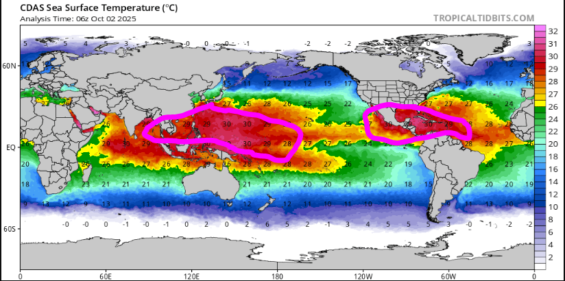
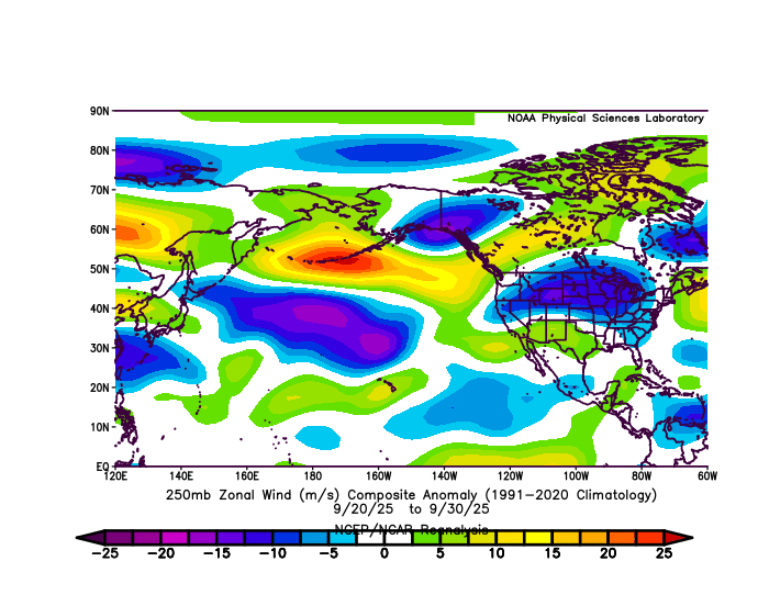
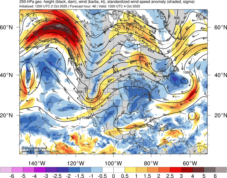
Unfortunately, the jet max out near the Aleutians was one of the strongest on record for late September. Right along the northern gradient of that record SST pool. Looks like more of the same next few days with a daily 5 sigma jet max. We saw how this lead to the record warmth around our area in late September. It’s no surprise the models are so warm for early October with near 90° heat forecast in places like MSP. https://mesonet.agron.iastate.edu/wx/afos/p.php?pil=AFDMPX&e=202510021750 These strong southerly winds will also usher in a very warm airmass, with highs both Friday and Saturday expected to be up around 90 west of I-35 and south of I-94 both days, which will put record highs in play both days for MSP and STC. The only saving grace when it comes to this heat is dewpoints won't be horrendous, mainly in the mid 50s to lower 60s. Still, when the Twin Cities has only seen the high meet or exceed 90 in October 3 times going back to 1872, this a rare airmass for us to see so late into the season.
-
Popcorn https://weather.cod.edu/satrad/?parms=local-Virginia-02-24-1-100-1&checked=map&colorbar=undefined Sun and clouds and 67 at 3pm. Very nice.


