All Activity
- Past hour
-

Occasional Thoughts on Climate Change
TheClimateChanger replied to donsutherland1's topic in Climate Change
-
Excellent weather in the Bay Area the past several days.

-
Forgot to add mine. 12/5-12-6: 1" 12/13-12/14: 3" 1/1: 0.2" 1/17: 0.5" 1/25: 10" 2/22-23: 3" Total: 17.7"
-
14 this morning here
-
30
-
Agree…all that concrete down there shows up easily on vis.
-
I got down to 27f. I've paid the oil company enough already and would really like to shut the heat off until November.
-

2026-2027 El Nino
A-L-E-K replied to Stormchaserchuck1's topic in Weather Forecasting and Discussion
-
Drought to worsen and fire conditions ramp up this weekend with warm temps, dewpoints in the low 50s and breezy conditions. Some signs of a more seasonally average shower/storm chances returning late next week. Hopefully the quick ramp up towards EL nino over the next few weeks will help to shake up the pattern and break down the ridge
-
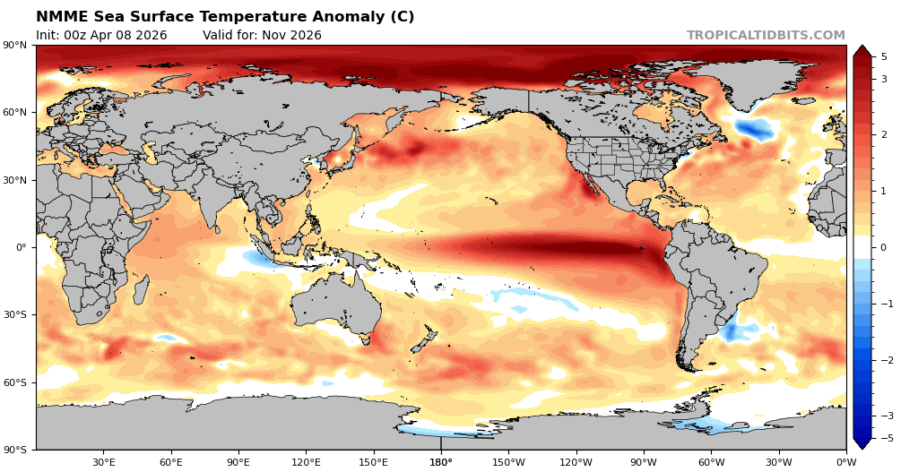
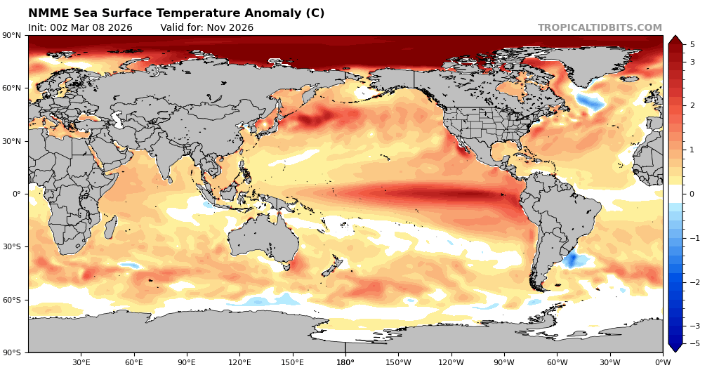
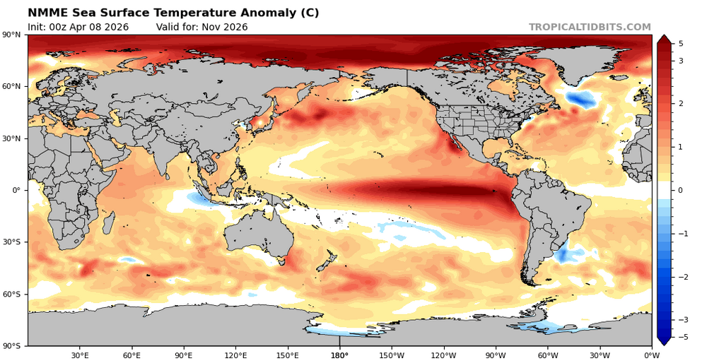
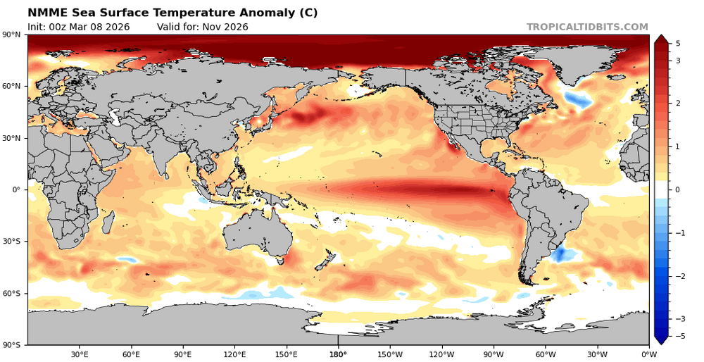
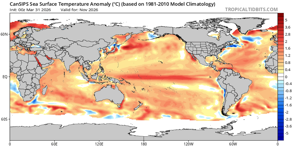
Nov: NMME is warmer than its prior run and much more E based than Cansips Modoki: Nov SSTa NMME latest run: Nov SSTa NMME prior run: Nov SSTa Cansips
-
23° for the low. Hopefully the last hard freeze until fall
-
April 8 1805: John Sayer at the Snake River Fir Trading Post near present day Pine City mentions: 'The most tempestuous (stormy) day of the year. Pines and other trees fell near the fort.' ^Note: Would seem a line of stms with strong straight line winds, or even a weak tornado, passed through EC MN region. A bit unusual this time of year this far N.^ For Wednesday, April 8, 2026 1919 - A tornado swarm in northern Texas resulted in the deaths of 64 persons. (David Ludlum) 1926 - The lightning-set oil depot fire near San Luis Obispo CA boiled over and engulfed 900 acres. Many tornado vortices resulted from the intense heat of the fire. One such tornado traveled 1000 yards, picked up a house and carried it 150 feet, killing the two occupants inside. (The Weather Channel) 1973 - A severe storm brought high winds and heavy snow to Iowa. Belle Plain received 20 inches of snow, and 19 inches blanketed Dubuque, record totals for both locations for so late in the season. Snow drifts up to sixteen feet high closed highways. (David Ludlum) 1987 - A cold front crossing the Northern Plateau and the Northern Rocky Mountain Region produced high winds in northeastern Wyoming. Winds gusting to 69 mph at Sheridan WY downed power lines and caused some property damage. (The National Weather Summary) (Storm Data) 1988 - Strong northerly winds ushered cold air into the north central U.S. The strong winds, gusting to 60 mph at Rapid City SD and Williston ND, reduced visibilities in blowing dust over the Dakotas. (The National Weather Summary) (Storm Data) 1989 - Two dozen cities in the southwestern U.S. reported new record high temperatures for the date. Phoenix AZ equaled their record for April of 104 degrees established just the previous day. (The National Weather Summary) 1990 - Twenty-two cities reported record low temperatures for the date as readings dipped into the 20s and 30s across much of the eastern U.S. Freezing temperatures severely damaged peach and apple orchards in West Virginia, where prolonged mild weather since January had caused an early blooming of spring vegetation. State and Federal agencies estimated a 50 percent loss in production for peaches and "Delicious Red Apples". (The National Weather Summary) (Storm Data) Note: That's one serious firenado WOW!
-
The only thing I can see is GWDLT
- Today
-
32 for the low
-
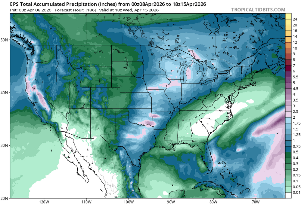
you can see the snow coverage pretty fantastically here... https://weather.cod.edu/satrad/?parms=subregional-New_England-02-24-1-100-1&checked=map&colorbar=undefined
-
Certainly can't rule that out this early in the season
-
ha... watch, the polar boundary ends up PIT - ACK ...and we have 38 -r with one or two pellets that day
-
Yeah, 3" seems a lot. It may be enough 'in the bank' to last it out.
-
March finished as 3rd warmest on record at RDU
-

E PA/NJ/DE Spring 2026 Obs/Discussion
BBasile replied to PhiEaglesfan712's topic in Philadelphia Region
Temp got down to 29.4F this morning. Currently 37. -
Sublimation is a stronger latent cooler than evaporation. We had over 3”. I expect it to mostly be gone by evening, but I don’t think we bust warm until tomorrow. Tonight looks like another strong rad night in the pits.

-
https://coolwx.com/record/
-
I agree with that, however, I think what we'd have to watch for is cloud cover from upstream precipitation/convection...though perhaps shear vectors favor us avoiding this mess.
-
I doubt it... The continent is too dry. The flow is WSW under that polar boundary transporting a kinetically charged well mixed layer originating from the west TX high country. Good luck. If we are safely in that warm conveyor like the GFS? not much cloud. That's a red flag warning scenario there this early and prior to our own geographical green up. Even if the RH sigmas are juicier ( 800 to 300 mb levels) I'd personally lean on that being dryer verifying.
-

Central PA Spring 2026 Discussion/Obs Thread
mahantango#1 replied to Voyager's topic in Upstate New York/Pennsylvania
We might have to go through litigation on this one.