All Activity
- Past hour
-
We were wet(rained) a lot of the morning here…drying out now.
-
Beautiful 59F, House is finally cooling off. The heat is brutal on the roof of my place. Light rain currently.
-

2026-2027 Strong/Super El Nino
Stormchaserchuck1 replied to Stormchaserchuck1's topic in Weather Forecasting and Discussion
New CPC Summer seasonal is much warmer than classic developing Strong Nino climo -
Haven't seen a forecast like this in a long time. Let's hope it materializes...
-
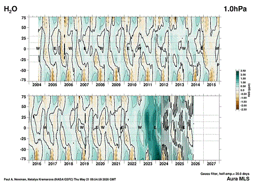
Found the site where stratospheric WV is shown at the various levels starting from the tropopause up to the top of the stratosphere. https://acd-ext.gsfc.nasa.gov/Data_services/met/qbo/h2o_mls.html My question is...Has the Hunga Tonga eruption in Jan 2022 greatly affected the climate system over the past few years with such a strong increase in WV within the stratosphere? We know that very large eruptions do affect the system for a few years, but this one was so different than the usual with such a large volume of WV injected so high up. It was awesome enough with the pressure waves circling the globe many times. Here's a slide show of the charts starting from the top down through the stratosphere into the tropopause.
-
monthly record highs were set with the heat wave. any monthly record lows on the horizon?
-
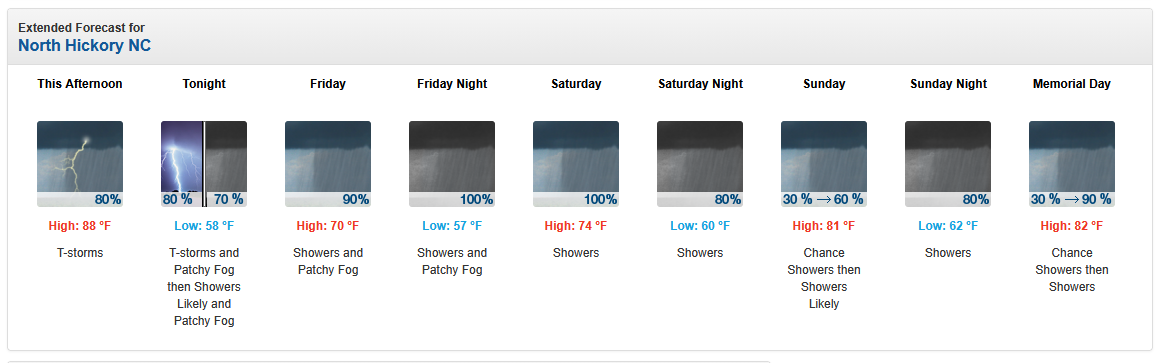
First 90 degrees day here yesterday, reached the mid 90s. Also 1.36 inches of rain. Currently 58 degrees.
-

Chester County PA - Analytical Battle of Actual vs. Altered Climate Data
chubbs replied to ChescoWx's topic in Climate Change
Sorry you are the guy using "fake math". You aren't maintaining a constant baseline in Chester County. There is only one station from the 1970 network that remains in 2025. On average the the 2025 stations are colder: DEOS vs COOP, or East Nantmeal vs Devault for instance. You are distorting the raw data by changing the station population. My table on the other hand is an unbiased apples to apples comparison, exactly the same data treatment for Chesco and Philly. That shows no difference in warming between Chesco and Philly Airport.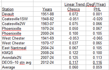
-
2026-2027 Strong/Super El Nino
Stormchaserchuck1 replied to Stormchaserchuck1's topic in Weather Forecasting and Discussion
Really a strong graduation. It's still intensifying in the far east -
It's 55F right now or nearly a 40F swing in 24hrs
-

Central PA Spring 2026 Discussion/Obs Thread
TheDreamTraveler replied to Voyager's topic in Upstate New York/Pennsylvania
Honestly today feels a lot better than I was expecting after all that heat. 56 currently and very cozy lol Also good to see we might get a lot of rain. Parts really need it bad. -

2026-2027 Strong/Super El Nino
snowman19 replied to Stormchaserchuck1's topic in Weather Forecasting and Discussion
That KW is a monster -
2026-2027 Strong/Super El Nino
snowman19 replied to Stormchaserchuck1's topic in Weather Forecasting and Discussion
-
Not sure, but I wouldn't bank on much more than 1:1 ratios
-
As usual, model extremes were wrong... not a shutout like AI-GFS had for days, not a 3-day washout like EC / ens had a few days ago... converging towards a 1.5 of 3 days dry: completely dry Saturday (probably copy of today cloudy highs to 60s) worst day Sunday Monday looks dry 2nd half... Only reason I'm scrutinizing is a family event on Charles Saturday evening so thankful it looks dry
-
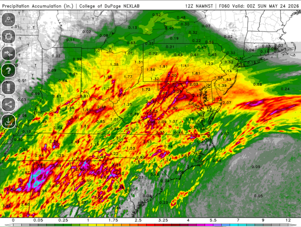
I'm more impressed with the NAM 12
-
So when is this shit gonna start shifting S? Feels like winter
-
Given the last couple years its been bleak so yeah, no surprise. EC canes dont exist anymore.
-
No surprise
- Today
-
Big fan of the 3km NAM. Let's do that.
-
ENSO subsurface is approaching the warmest ever, below Nino 1+2. El Nino seasonal patterns may follow, except for temps which effected by the -PDO/-ENSO state that is currently strong in the North Pacific.
-
15 miles south-east of you... 0.00
-
I like what you did here.. .
-
How much of this is snow?
-

E PA/NJ/DE Spring 2026 Obs/Discussion
Chadzachadam replied to PhiEaglesfan712's topic in Philadelphia Region
got about 0.40" here yesterday, the sky never really opened up like it threatened to... until today, as we have had a couple legitimate downpours in the last hour or two. steady rain now, approaching 1.00" over the last 24 hours