All Activity
- Past hour
-

Richmond Metro/Hampton Roads Area Discussion
wasnow215 replied to RIC Airport's topic in Mid Atlantic
I'm from Atlantic County in South Jersey originally. Ended up moving a little bit west and graduated from Washington Township High. Followed all four teams my whole life and I've been to 2008 Phillies parade and both Eagles parades -

Jan 24-26 Weekend Snow and Sleetfest Model Thread Part Tres
winter_warlock replied to H2O's topic in Mid Atlantic
Probably sleet accumulate after that -

Extreme Cold, Snow & Sleet: SECS 1/24 - 1/26
jm1220 replied to TriPol's topic in New York City Metro
The nature of this storm is pretty clear that New England would get nailed a few days ago. It was pretty clear to everyone this wouldn’t end up a VA/Mid Atlantic snowstorm. Retreating high, retreating confluence, trough in the west and SE ridging=SWFE that favors I-90, Boston over to Albany and S NY. The initial high pressure/overrunning gives people like us down to DC a fighting chance but the best is along I-90. I-84 should do very well too. -

Central PA Winter 25/26 Discussion and Obs
Jns2183 replied to MAG5035's topic in Upstate New York/Pennsylvania
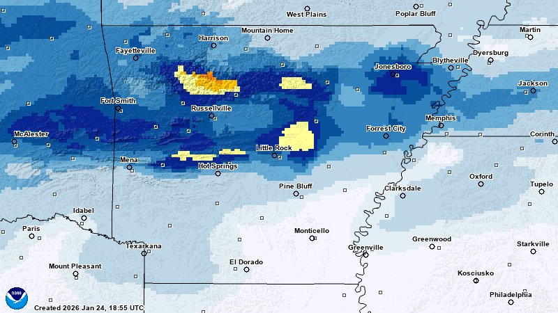
That's the 3k nam, reg nam, observed The NAM suite’s performance during the Arkansas snowfall event was a case study in systematic failure, characterized by a severe northwest displacement and a critical underestimation of moisture transport. Both the NAM 3km and Parent models shifted the entire storm track 95–110 miles too far northwest, which effectively "erased" the heavy 7.8-inch snow core from Central Arkansas by placing it in a modeled dry slot. While the models were predicting 0.0" for Little Rock and Conway, the actual atmosphere was tapping into a rich Gulf moisture plume that the NAM fundamentally failed to resolve, leading to a massive +7.8-inch error at the storm's most intense point. The root of this "NAM Gap" was a flawed thermal profile that modeled the 850mb "warm nose" much too aggressively and far north of its verified position. By over-amplifying the ridge ahead of the storm, the NAM physics engine incorrectly predicted that dry air would "eat" the incoming precipitation shield, when in reality, the column stayed cold and saturated enough for high-impact snowfall. For those tracking the storm's progression into the Ohio Valley and Northeast, the takeaway is clear: the NAM’s known dry bias and tendency to over-pump warm air can lead to a 100% miss in the transition zone, making a weighted consensus of the HRRR, Euro, and NBM a far more robust strategy for defining the true snow line. Sent from my SM-S731U using Tapatalk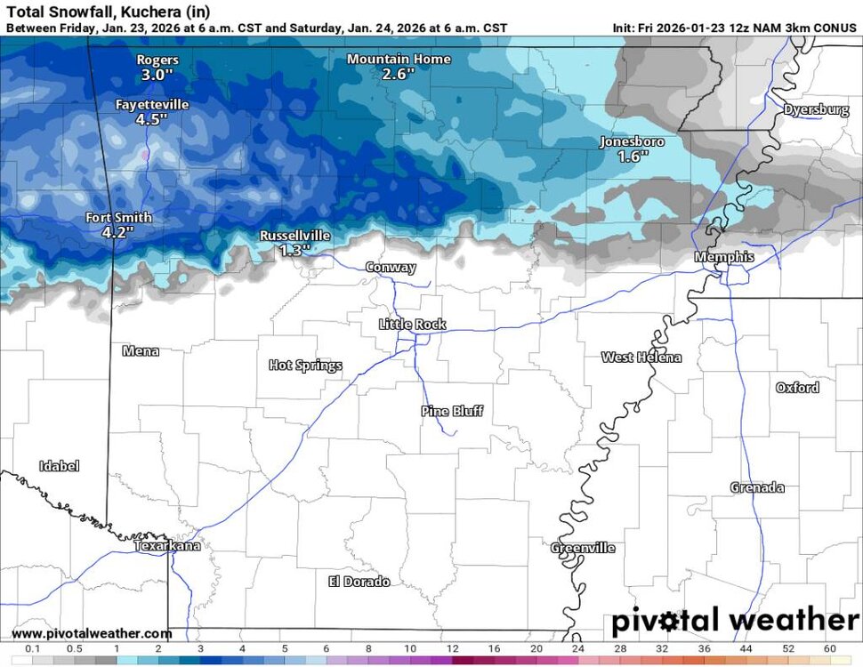
.thumb.jpg.d1bf6965ee88bba0598d38bde3f2935a.jpg)
-
 It's all ice
 -

Extreme Cold, Snow & Sleet: SECS 1/24 - 1/26
danstorm replied to TriPol's topic in New York City Metro
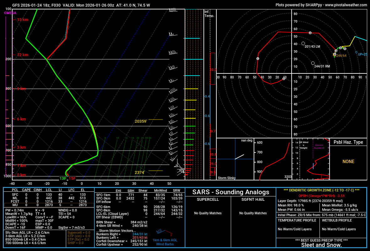
This is BARELY sleet (GFS sounding near me) and likely snow/sleet… with heavy rates it’s probably snow This is not the kind of storm that flips to sleet and done, that’s why I think my 8” call here may be low… I had 4/5 inches after mixing with sleet in Mar 2017 and this could be similar
-

“Cory’s in LA! Let’s MECS!” Jan. 24-26 Disco
RUNNAWAYICEBERG replied to TheSnowman's topic in New England
It’s Ron Washington time. Sprawled out, laughing, belly out… -

January 24-26: Miracle or Mirage JV/Banter Thread!
adelphi_sky replied to SnowenOutThere's topic in Mid Atlantic
I should have gotten Vodka for this Vodka cold. lol -

MO/KS/AR/OK 2025-2026 Winter Discussion
schoeppeya replied to stormdragonwx's topic in Central/Western States
Yeah that image the HRRR is showing at max .5 inch an hour rates for a couple hours... never truly get up into snow+ on the HRRR for all of round 2. The 3k nam and GFS still show hope so we will see, im leaning dry air wins at this point. -

Jan 24-26 Weekend Snow and Sleetfest Model Thread Part Tres
Weather Will replied to H2O's topic in Mid Atlantic
WB 18Z GFS: please be correct!!! At Church, I am praying.

-
 Ice accrual device: I wish I could hang the beer can up, but I'm not sure how to work that out without a mini net.
 -

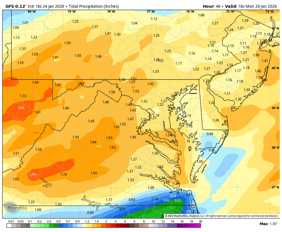
Jan 24-26 Weekend Snow and Sleetfest Model Thread Part Tres
mappy replied to H2O's topic in Mid Atlantic
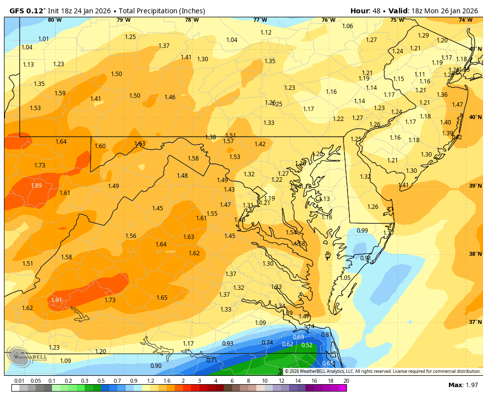
Gfs has been consistent in qpf total for my backyard for days 1.2-1.4 range. Yes, it’s gonna sleet, just wanna squeeze as much fluff out that qpf as I can before it mixes lol -
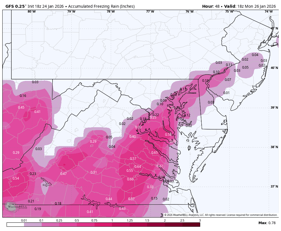
 Does anyone know if this graphic from the latest HRR for freezing rain is all freezing rain or does it also include sleet?
-

Central PA Winter 25/26 Discussion and Obs
Superstorm replied to MAG5035's topic in Upstate New York/Pennsylvania
GFS slightly better for border counties. . -

Southern Crippler - Get well soon Jimbo Storm Obs
ncstatered21 replied to BooneWX's topic in Southeastern States
My god didn’t realize it was that cheap. Subbed. Nothing really to report from Holly Springs for me. Cold AF. 27F air. . -
 It is absolutely dumping turkey feathers here right now no mix at all but just pouring snow! Huge flakes!!
- 298 replies
-
- 3
-

-
- observations
- obs thread
- (and 1 more)
-

Jan 24-26 Weekend Snow and Sleetfest Model Thread Part Tres
Scarlet Pimpernel replied to H2O's topic in Mid Atlantic
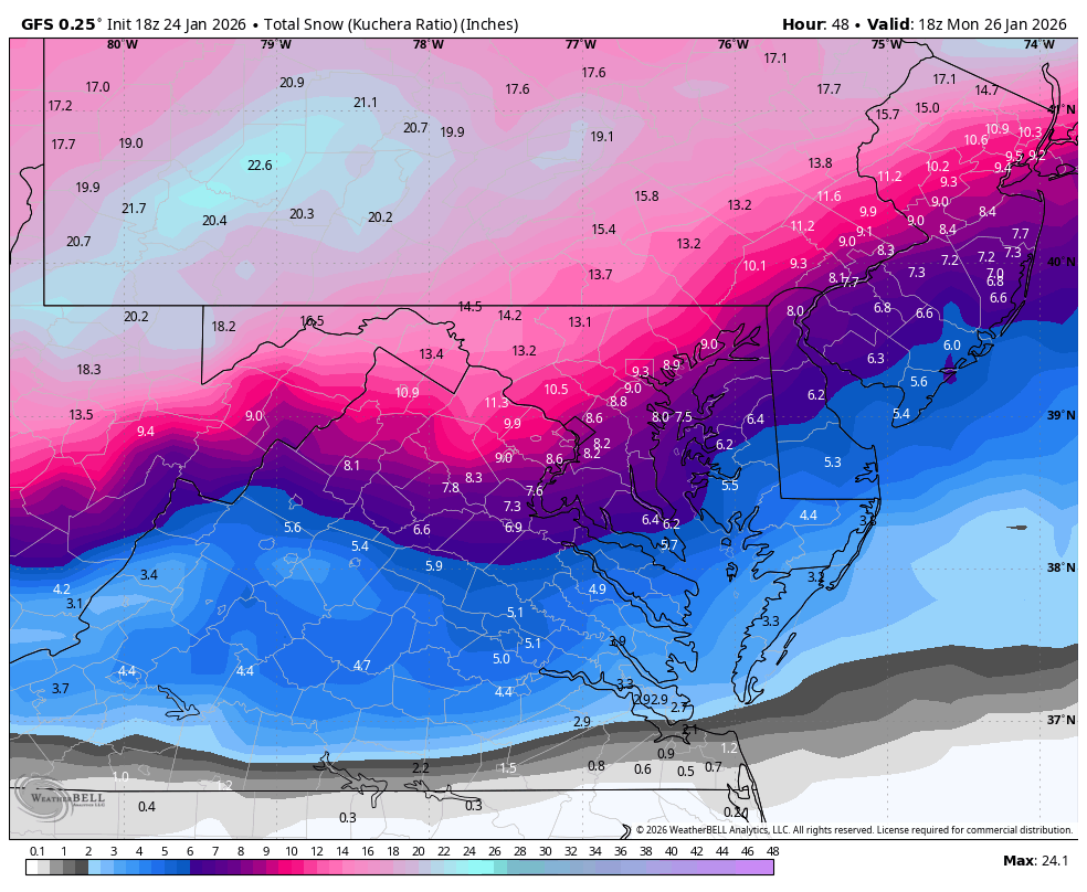
GFS around 8-10" through 18Z, according to TT 10:1 maps? That may be a little while after a flip but it's close to that time. Certainly after that it's sleet. (ETA: Talking about the DC-Balt metro corridor) -
Enjoy
-

Southern Crippler - Get well soon Jimbo Storm Obs
NCSU_Pi replied to BooneWX's topic in Southeastern States
I just use whatever I got off the Google Play Store... Or maybe I side-loaded it, I can't remember. It's just called "mPing". -
https://news.duke-energy.com/releases/winter-storm-fern-duke-energy-has-18-000+-workers-from-27-states-and-canada-ready-to-respond Helps enroute
-
 I keep saying warm nose, but that looks more like the air being squeezed downsloping both side of the Hatchery Station
 -

Extreme Cold, Snow & Sleet: SECS 1/24 - 1/26
nycsnow replied to TriPol's topic in New York City Metro
I mean I’m sure hrrrrr will fluctuate run to run but it’s been pretty locked in. Nam and gfs by far have been moving around the most of any suite -

Extreme Cold, Snow & Sleet: SECS 1/24 - 1/26
MJO812 replied to TriPol's topic in New York City Metro
It has a weird dryslot -

Jan 24-26 Weekend Snow and Sleetfest Model Thread Part Tres
RickinBaltimore replied to H2O's topic in Mid Atlantic
We REALLY need that. -

January 25-26 Winter Storm Potential
PhilsFanDrew replied to Ralph Wiggum's topic in Philadelphia Region
It's reasonable but I believe because the cold air is in place at the onset the ratios especially as you get to the NW of I-95 are going to be somewhere between 15:1-20:1. Even if there is mixing that reaches as far as Northampton/southern Carbon county, I think it's when there is already nearly a foot of snow on the ground and if that was snow it would be of the lighter variety that would only add an additional 3-4 inches.

.jpg.7974897f1332a41848fa5d274d180e6b.jpg)