All Activity
- Past hour
-

Possible Record Breaking Cold + Snow Sunday 1/25 - Tuesday 1/27
ILoveWinter replied to TriPol's topic in New York City Metro
The NAM is not infallible when it comes to being the most aggressive with warm noses but agree that it could verify. I do wonder why in this instance it is the most aggressive - is it because it tracks the primary further north vs the other models? Does it show a stronger primary? -
Hmmm euro has had near 1 qpf consistently before any flip for us. Easy foot with high fluff ratios
-
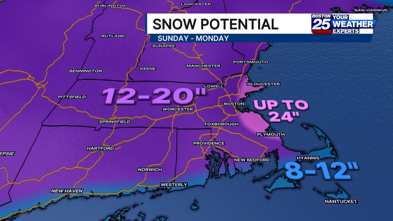
For my areas I'm thinking 12 to 18. What's nice with this system, if it comes to fruition is that it's apparently trying to spread the love in quite a large area. Love to see it
-
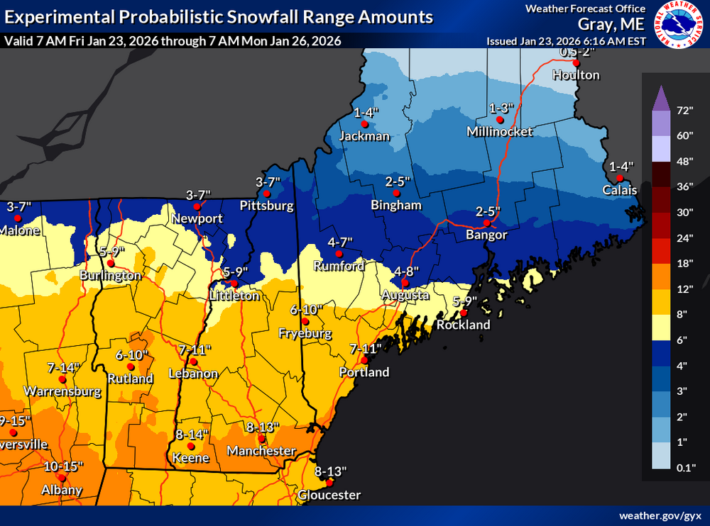
I think this is a good opener for GYX.
-
Agreed. I could be much more harsh than subtle undertones when it comes to NWS but I won't. How's that for subtle LOL
-

Central PA Winter 25/26 Discussion and Obs
southpark replied to MAG5035's topic in Upstate New York/Pennsylvania
To toy with our emotions -

Richmond Metro/Hampton Roads Area Discussion
RVASnowLover replied to RIC Airport's topic in Mid Atlantic
Improvement on the UK as well -
-11F this morning
-

“Cory’s in LA! Let’s MECS!” Jan. 24-26 Disco
Damage In Tolland replied to TheSnowman's topic in New England
Close to what I’m thinking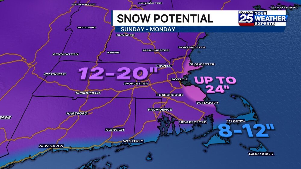
-

“Cory’s in LA! Let’s MECS!” Jan. 24-26 Disco
mahk_webstah replied to TheSnowman's topic in New England
I was tempted to think we might be more like 12 to 16 but I have seen on a number of the precipitation outputs that they are are lower numbers in the Merrimack Valley like often happens due to banding to our south or north. So I’m also thinking about 10 to 14. -

“Cory’s in LA! Let’s MECS!” Jan. 24-26 Disco
ScituateMA replied to TheSnowman's topic in New England
I just dont see this verifying. Its still nice to see though. The storms where the south shore jackpots always tend to be huge systems.
-
No legit model really has us getting over 12". But hey if we do then good.
-

Possible Record Breaking Cold + Snow Sunday 1/25 - Tuesday 1/27
BoulderWX replied to TriPol's topic in New York City Metro
The NWS actually added an inch to my WSW - 12-17. Not sure what they’re looking at. -
Unfortunately, just like your thoughts, we can't see them lol Sent from my SM-S938U using Tapatalk
-
Marginal improvements in snow on the EURO for upper mid TN and KY-VA border counties with the initial thump. Backend flakes still a no show.
-

1/24-1/25 Major Winter Storm - S. IL, IN, MI and OH
Stevo6899 replied to A-L-E-K's topic in Lakes/Ohio Valley
If only the low didnt transfer so fast and strengthen as it moves up into Ohio. Perfect track for Detroit. Potential big dog wasted, shame. -
It’s a good map, too low up here tho imo
-
“Cory’s in LA! Let’s MECS!” Jan. 24-26 Disco
Damage In Tolland replied to TheSnowman's topic in New England
Meaning they don’t have the final say , they aren’t the go to end all be all Unless of course you choose that as your main source. -
If I still had photoshop and time to make a detailed map I would. Just wanted to get my thoughts out there.
-
The hard to read text was the first thing I noticed
-

Pittsburgh/Western PA WINTER ‘25/‘26
Rd9108 replied to Burghblizz's topic in Upstate New York/Pennsylvania
Good to see i woke up and the warm tongue isnt licking all the way into northern PA or anything. Ill take a small south adjustment. -
I'm going with 10-14" here, This is still a SWFE unless you get a secondary to develop its has a ceiling.
-

January 25-26 Winter Storm Potential
Hurricane Agnes replied to Ralph Wiggum's topic in Philadelphia Region
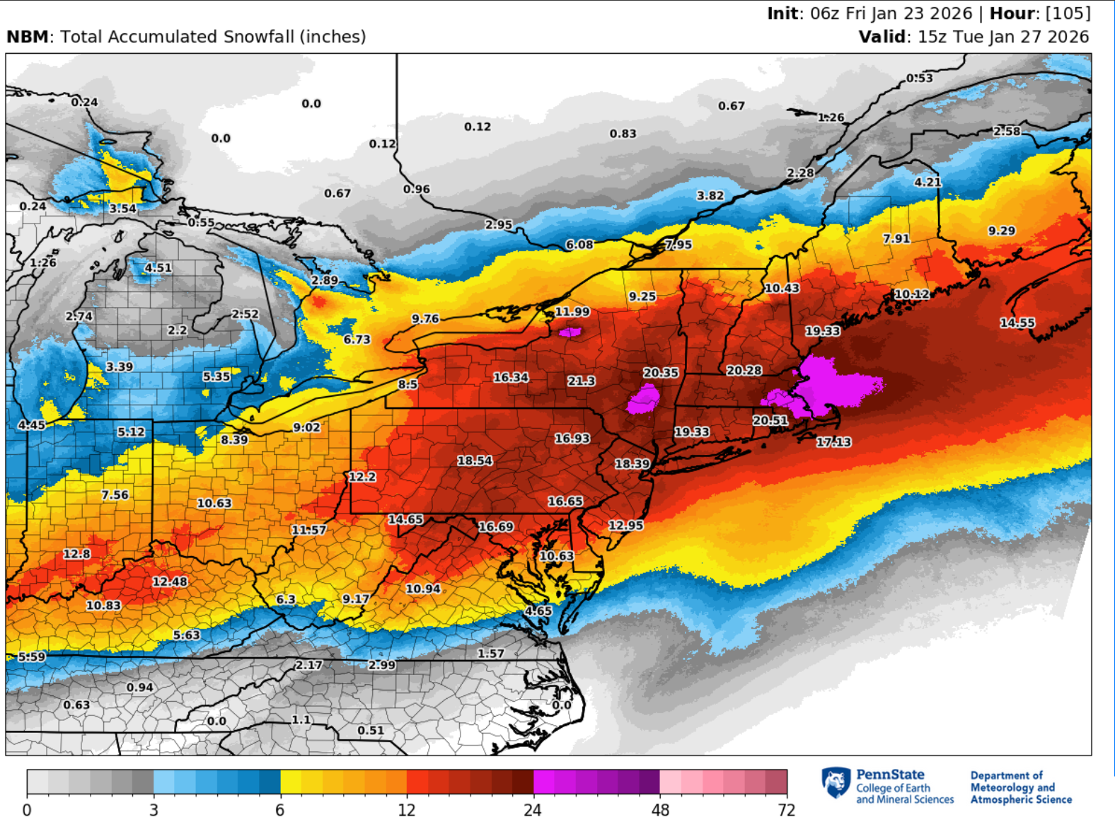
7z NBM.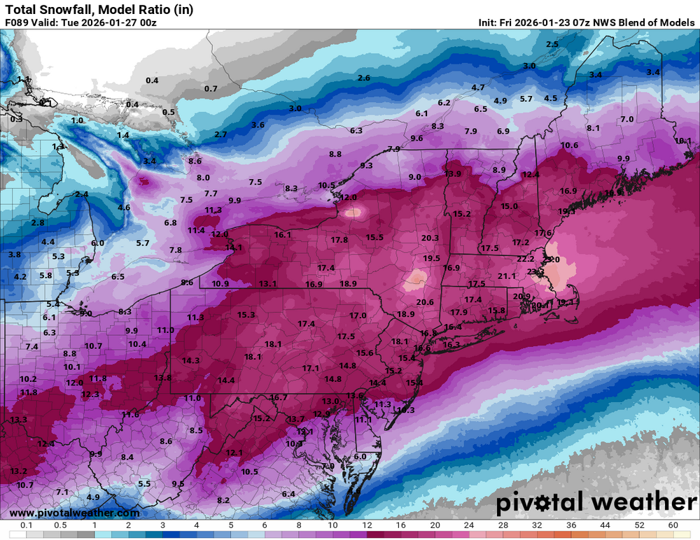
-

Possible Record Breaking Cold + Snow Sunday 1/25 - Tuesday 1/27
weathermedic replied to TriPol's topic in New York City Metro
Good AM discussion out of OKX The overall synoptic picture into early next week continues to sharpen. At the surface, arctic high pressure slides east from the Great Lakes into the Northeast this weekend. Meanwhile, low pressure develops and tracks through the South before redeveloping off Cape Hatteras, passing near or just inside the 40N/70W benchmark into Monday. Aiding the potential for snowfall, an arctic air mass settles in ahead of the storm. 925 mb temps look to fall toward -20C or below on Saturday, with surface temperatures progged in the teens during the afternoon, setting up one of the coldest days in several years. This will allow snow to fall everywhere at the onset, which looks to develop rather quickly either very late Saturday night, or more likely Sunday morning around or after daybreak. Periods of heavy snow then appear likely late Sunday morning through the afternoon via the strong frontogenetic and thermal forcing aided by an anticyclonic upper jet to the north. Snowfall rates in this period likely eclipse 1 in/hr at times, perhaps closer to 2 in/hr. Given the cold air mass in place initially, SLRs start out on the higher side (15-18:1) at onset, gradually falling back toward 10:1 or lower along the coast by late afternoon as the mid levels warm. With guidance having adjusted to a closer to the coast surface low, the proximity introduces the possibility of enough warm air intrusion around 800 mb for the snow to mix with or change to sleet Sunday evening. Best chances for this are along the coast, including Long Island and NYC metro. Lower confidence in this occurring going north, with all snow still the most likely solution into the Lower Hudson Valley and Southern Connecticut. Freezing rain or drizzle also cannot be ruled out, though significant icing appears unlikely. As the coastal system deepens and lifts north and east into Monday, the boundary cools once again, and any wintry mix likely tapers as snow showers or flurries into late Monday morning or afternoon. Any additional accumulation is likely light. Forecast snowfall totals have decreased slightly along the coast. This is due to the increased potential for mixing as the warmer air aloft works in. It should be emphasized though the heaviest and steadiest precipitation is expected Sunday morning into early evening, with the bulk of snow accumulation occurring prior to any potential changeover. With QPF progged over an inch, areas that remain all snow should be able to yield double digit snowfall. The question becomes how much warm air is able to work in and force a changeover to sleet, cutting down snow totals. All said, still expecting a widespread 8 to 14 inches across the region, with localized amounts perhaps approaching a foot and a half where best banding sets up and ptype remains all snow. Greatest likelihood for this is across the interior. We remain just over 48 hours from event onset, so opted for no headline changes with this update. It appears likely warnings will be warranted for all areas later today or tonight, dependent on no significant deviations in forecast thought. Continue to monitor the forecast on what is increasingly likely to be a major winter storm with significant disruption to travel and daily life early next week. -

January 24-26: Miracle or Mirage JV/Banter Thread!
anotherman replied to SnowenOutThere's topic in Mid Atlantic
It’s the reason people were freaking out about this three or four days ago. Well, that and social media computer models being shared.