All Activity
- Past hour
-
Latest from GSP: ...ICE STORM WARNING REMAINS IN EFFECT UNTIL 1 PM EST MONDAY... * WHAT...Damaging icing expected. Additional sleet accumulations up to one inch and ice accumulations between three tenths and one inch. Winds gusting as high as 45 mph. * WHERE...The mountains of northeast Georgia, upstate South Carolina, and portions of southwest North Carolina. * WHEN...Until 1 PM EST Monday. * IMPACTS...Significant ice accumulation on power lines and tree limbs may cause widespread and long-lasting power outages. Ice covered roadways will become treacherous and impassable. The hazardous conditions could impact the Monday morning commute. Gusty winds could bring down tree branches. * ADDITIONAL DETAILS...Ice accumulations will rapidly increase late tonight into Sunday morning, possibly tapering off by Sunday evening. Treacherous road conditions and power outages will remain Sunday night and likely linger through at least Monday.
-

1/24-1/25 Major Winter Storm - S. IL, IN, and OH
Radtechwxman replied to A-L-E-K's topic in Lakes/Ohio Valley
Got some flurries here despite RH in 40's. Once heavier precip moves in towards evening and better upper level support from main wave, rates should pick up. -

Richmond Metro/Hampton Roads Area Discussion
Deep Creek replied to RIC Airport's topic in Mid Atlantic
Ha, yea. I’m showing 20/-3 here in North Chesterfield. NGL, while I’m nervous about the freezing rain potential tomorrow, I’m kinda excited about not really knowing how tomorrow will play out and just seeing what falls… -
Couple that with the multi-billion hole in the ground at VC Sumner....my next door neighbor actually had to come in and try to fix that whole mess Nuke plants take forever to build, but are by far the best option- I am right across the lake from Catawba Nuclear- over 40 yo at this point, and still generates a large percentage of CLT's power needs Main issue now has to do with data centers- they eat up an enormous supply of power that is enormously disproportionate to Residential usage Coal-fired in the US got a really bad rap, and the thought process behind decommissioning was ill-conceived at best. As stated earlier, there was no viable plan for replacing the lost output. Look at Western Europe if you want to see some really f'd up policy with regards to electrical resources- they didn't just shoot themselves in the foot, they blew their whole leg off....the cognitive dissonance between ideals and actual reality is frankly astounding
-

“Cory’s in LA! Let’s MECS!” Jan. 24-26 Disco
Typhoon Tip replied to TheSnowman's topic in New England
actually I think that tough 26 and change Feb 2003 I think it was. ..I coulda swore. -
 The 3k has me at 25 at 3pm. The HRRR 24.
 -

Extreme Cold, Snow & Sleet: SECS 1/25 - 1/26
eduggs replied to TriPol's topic in New York City Metro
The RGEM is a strong thump with several hours of legitimately heavy snow. But it still brings sleet in late afternoon. The LHV on north stays mostly snow and continues lightly through Mon morning. -

“Cory’s in LA! Let’s MECS!” Jan. 24-26 Disco
Ginx snewx replied to TheSnowman's topic in New England
Hmm Kooch seems to be the go to in cold non windy events. Thanks for the link -

Jan 24-26 Weekend Snow and Sleetfest Model Thread Part Tres
MillvilleWx replied to H2O's topic in Mid Atlantic
Yup! -

Jan 24-26 Weekend Snow and Sleetfest Model Thread Part Tres
SomeguyfromTakomaPark replied to H2O's topic in Mid Atlantic
NAM adjusting south with the rain snow line at hour 12 in the Ohio valley. -

Pittsburgh/Western PA WINTER ‘25/‘26
MikeB_01 replied to Burghblizz's topic in Upstate New York/Pennsylvania
Very much in line with the NWS latest discussion that @Mailman posted. Good to see some support for that solution. . -

Extreme Cold, Snow & Sleet: SECS 1/25 - 1/26
Winterweatherlover replied to TriPol's topic in New York City Metro
I don't see it even out but if accurate thats a strong signal the NAM may be wrong. -

January 24-26: Miracle or Mirage JV/Banter Thread!
poprock49 replied to SnowenOutThere's topic in Mid Atlantic
12z RGEM finally ran - looks super heavy with the thump! Holds back the sleep maybe another 1/2 hour to an hour -
lol I know.
-
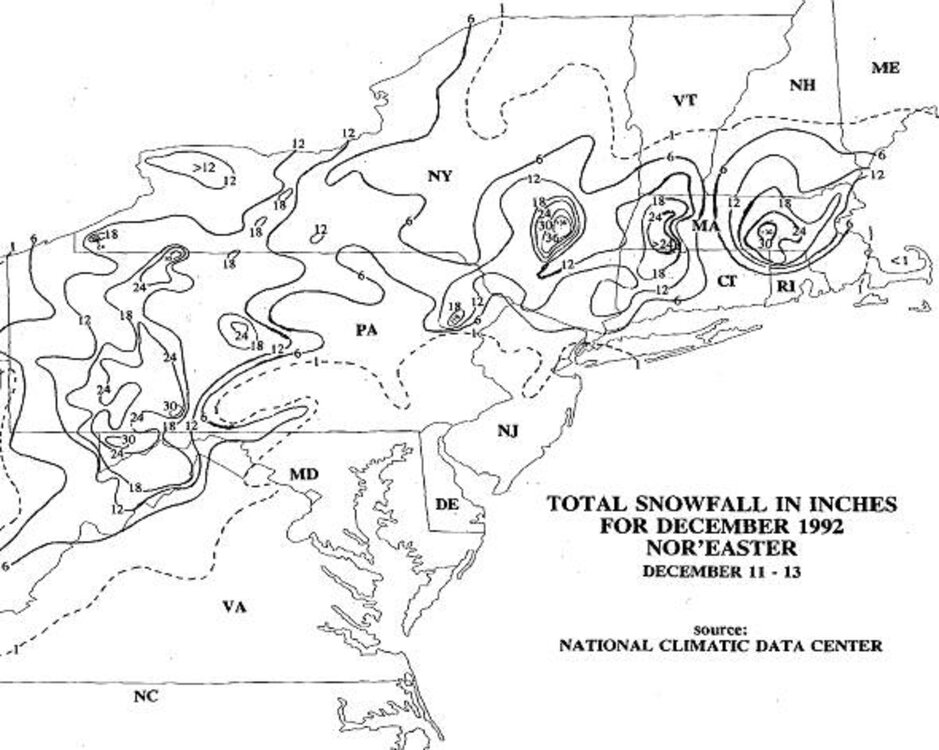
How about this one? Dec 11-13, 1992. This was the one the started it all. The first blockbuster coming out of the snow drought since the mid 80s. I had 18" in Woburn. Biggest single storm snowfall I had I think since the April 1982 blizzard. What made this odd, is that I had a ton of rain Dec 11, and then a ton of snow on Dec 12. It is very rare to have so much rain and then so much snow in two parts in one storm over 48 hr in the NEUS! And the R/S line on Dec 11. One of the sharpest and most stationary for such a long time I have ever seen. In the evening, Nashua already had 6" and in Billerica nothing. Drove N on Rt 3 just after midnight, and not even a mi N of 495, hit a snow covered road like a wall. Got to Drum Hill in Chelmsford, and it was fluff and hardly any wind. Then the R/S line collapses S a few hours later and the rest is history! CoastalWx was totally ripped off in Brockton. Slushy mess while 5 mi NW of him over a foot!
-

“Cory’s in LA! Let’s MECS!” Jan. 24-26 Disco
WinterWolf replied to TheSnowman's topic in New England
Tell me what that shows Paul? Driving home from northern Maine as we speak. -
25.4” in April ‘97. There is a zero percent chance that gets broken in this storm.
-

“Cory’s in LA! Let’s MECS!” Jan. 24-26 Disco
Cold Miser replied to TheSnowman's topic in New England
All the way into the gulf. Surreal. -

1/24-1/25 Major Winter Storm - S. IL, IN, and OH
Stevo6899 replied to A-L-E-K's topic in Lakes/Ohio Valley
Not gonna lie rap/hrr more than 12 hours out is just as useless as looking at the nam at all. -
Thoughts on RGEM? Too cold?
-

Jan 24-26 Weekend Snow and Sleetfest Model Thread Part Tres
AU74 replied to H2O's topic in Mid Atlantic
Maybe the 1993 "Storm of the Century". -

“Cory’s in LA! Let’s MECS!” Jan. 24-26 Disco
moneypitmike replied to TheSnowman's topic in New England
where is that Jeff? -
NAM’s being decommissioned for a reason, which likely also means it hasn’t been getting resources for a bit. I’m with you. RGEM and HRRR. NAM can be good with thermals but has lost its edge and LOL at ever posting RAP. .
-
It's wetbulbiing. My dew point was 4 earlier. It's up to 18 now. I'll probably bottom at 19 or 20.
- 195 replies
-
- 1
-

-
- observations
- obs thread
- (and 1 more)
-
 I’m not saying this to be like those fools on Facebook but everything about this forecast has been wrong one way or another. I worry that with this system not phasing correctly we won’t see that warm nose ejecting itself to raise surface temperatures tonight/tomorrow. .


