All Activity
- Past hour
-
If this was two months ago the Euro would be getting bashed right now for pulling the plug on Mon/Tues. Glue factory
-
So I wonder, does Gritty know how to use a broom?
-
Phenomenal morning out this way; tough to work inside when it’s like this.
- 798 replies
-
- 1
-

-
- april showers bring may..
- rain
- (and 2 more)
-
It used to be a near guarantee this time of year to have 2-3 cutoff ULL’s get trapped in the southeast and produce a week straight of light rain and cool weather.
-
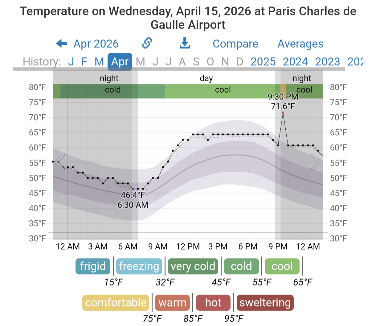
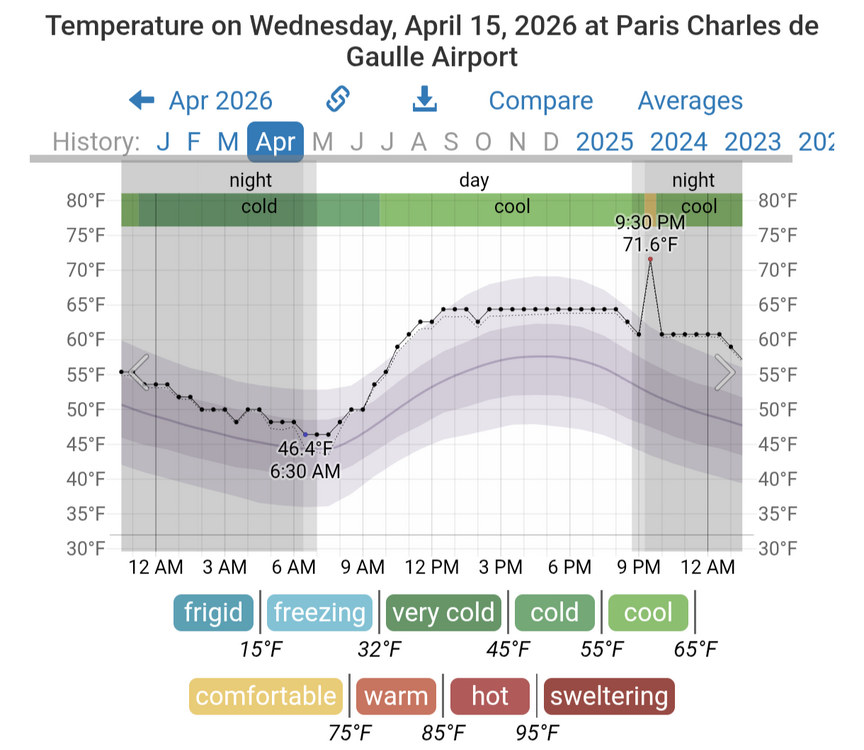
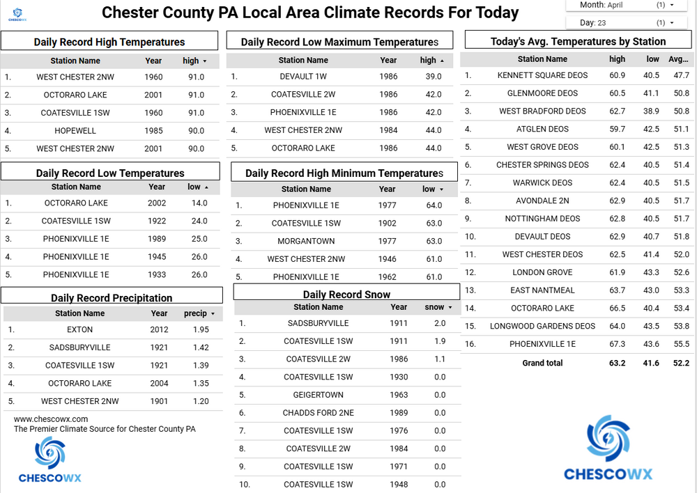
Pretty extreme how repetitive these patterns are becoming with both the 2023 and 2026 having spring crop damage from cold following early record warmth. Newark Area, NJPeriod of record: 1843-05-01 through 2026-04-22DateHighest maximum temperatures (degrees F) Top Record 2nd Record 3rd Record 4/13 92 in 2023 86 in 1977 84 in 2018+ 4/14 93 in 2023 89 in 2026 88 in 2022+ 4/15 91 in 2026 88 in 1960 87 in 1941 4/16 92 in 2002 90 in 2026 89 in 1896
-
Winter is slowly dying, Jerry is smart.
-
This man must’ve visited RDU a few times before
-
Absolutely horrific
- 798 replies
-
- 1
-
-
- april showers bring may..
- rain
- (and 2 more)
-
Thought y'all might get a kick out of this
-
The heart of the winter…gone for you Jerry. I’m sad for you…but if there’s a big one you, can fly home like you did this year too, so there’s that.
-
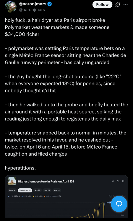
(002).thumb.png.6e3d9d46bca5fe41aab7a74871dd8af8.png)
Central PA Spring 2026 Discussion/Obs Thread
ChescoWx replied to Voyager's topic in Upstate New York/Pennsylvania
Today will likely be our mildest day for quite a while. We start a cooling trend tomorrow and it looks like our pattern over at least the next several weeks will feature generally below normal temperatures and above normal precipitation. Of note since March 1st we are at about 80% of our normal precipitation. We could pick up a 1/2 to 3/4 of an inch of rain from Friday night through Saturday. Saturday will be a chilly and raw day with winds off the still chilly ocean keeping temperatures not far from the current ocean water temp of around 50 degrees. Temperatures next week look to remain a little cooler than normal with rain chances increasing again by Monday night into Tuesday.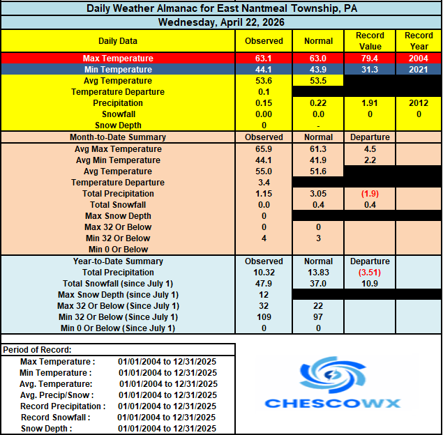
-
E PA/NJ/DE Spring 2026 Obs/Discussion
ChescoWx replied to PhiEaglesfan712's topic in Philadelphia Region
Today will likely be our mildest day for quite a while. We start a cooling trend tomorrow and it looks like our pattern over at least the next several weeks will feature generally below normal temperatures and above normal precipitation. Of note since March 1st we are at about 80% of our normal precipitation. We could pick up a 1/2 to 3/4 of an inch of rain from Friday night through Saturday. Saturday will be a chilly and raw day with winds off the still chilly ocean keeping temperatures not far from the current ocean water temp of around 50 degrees. Temperatures next week look to remain a little cooler than normal with rain chances increasing again by Monday night into Tuesday.
- Today
-
CC: @usedtobe and @BlizzardNole
-
Quite the weekend battle-alot of rain to no rain in a short distance. RGEM and NAM with sharp cutoffs
-

Central PA Spring 2026 Discussion/Obs Thread
Mount Joy Snowman replied to Voyager's topic in Upstate New York/Pennsylvania
Low of 46 with .04” of rain. Today is a mow day. -
Welp…we had one season we could dream… back to garbage
-
8 days to go!!! Getting exciting
-
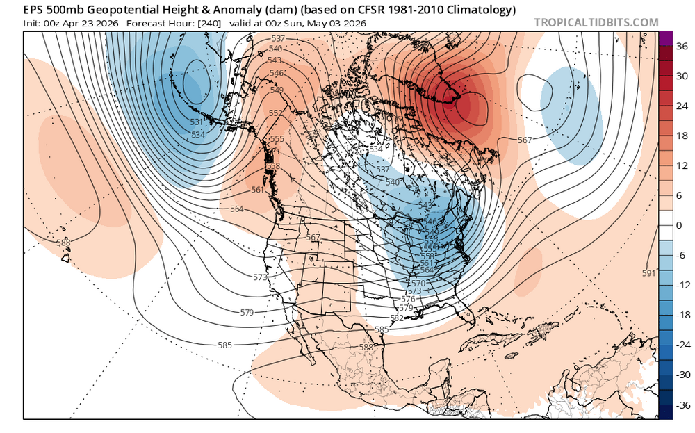
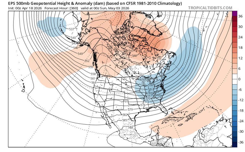
Models correcting stronger with the blocking to start May as this El Niño is developing at a record pace for this time of year. So the growing El Niño combining with other elements will cap the high end warmth potential for a while. We saw something like this back in the spring of 2023 following the April record 90°+ heat with that El Niño which formed early also. New run Old run
-

2026-2027 El Nino
bluewave replied to Stormchaserchuck1's topic in Weather Forecasting and Discussion
In effect that is what happened with the El Niño in 2018-2019 which had La Niña elements preventing it from fully coupling. Perhaps if the RONI and ONI can come into closer alignment it could suppress the Southeast ridge more than we saw back in 2023-2024. But that is really speculative at this point. It looks like we are headed for over +2.0 again on at least ONI and can use this as another test case. None of the seasonal models back in 2023-2024 were able to correctly forecast the stronger ridge building down into the Mid-Atlantic. As they all had the stock El Niño composite. -

2026-2027 El Nino
roardog replied to Stormchaserchuck1's topic in Weather Forecasting and Discussion
So what we're really saying here is that a weak to moderate El Nino will act like a La Nina while a strong or Super El Nino will act like a strong or super El Nino with a SE ridge. Sorry Mid Atlantic. lol -
2026-2027 El Nino
bluewave replied to Stormchaserchuck1's topic in Weather Forecasting and Discussion
The 2023-2024 event highlighted the weakness of relying on RONI for that super El Niño when the surrounding tropics were so warm since it amplified the warming even more than the ONI value due to dual warming centers in the Pacific. When the RONI paper came out most of it was focused on the La Nina intensity getting masked by the rising Nino 3.4s while the differential between the WPAC warm pool driving the EWBs suggested the lower RONI than ONI. So the paper never really focused on higher end El Niño events with dual warming centers lowering the RONI. So the new RONI isn’t really a one size fits all solution or an adequate replacement for ONI with higher end El Niño events. https://www.nature.com/articles/s43247-025-02971-1 During the 2023-24 El Niño, the July 2023–June 2024 average global mean surface temperature peaked at 1.58 °C above pre-industrial levels, associated with a record 0.36 °C year-over-year rise. Here we use statistical models and a Green’s Function method to explore the causes for this rise. We show that sea surface temperature accounts for ~92% of the interannual warming, highlighting the critical role of El Niño diversity. Unlike typical El Niños, dual tropical Pacific warming centers in 2023-24 and an eastward-extended North Atlantic jet stream synergistically amplified sea surface temperatures across tropical basins, accelerating the pace of global warming. From an energy balance perspective, ocean heat content accumulated during the preceding La Niña and a continuous increase in absorbed shortwave radiation over the ocean drove sea surface temperature rise. Accelerated warming may push the climate system closer to critical tipping points, emphasizing the need for enhanced monitoring, mitigation, and adaptation strategies. -

E PA/NJ/DE Spring 2026 Obs/Discussion
Mikeymac5306 replied to PhiEaglesfan712's topic in Philadelphia Region
Will the Phillies win before AJ Brown is traded? Will there be snow in May? Will the sun go down before it gets dark? Will the Flyers win it all? Will my garage fridge still have beer in it come Sunday? Will the Sixers fool the NBA? Will it hit 90 in May? These questions and a whole lot more at eleven. -
Poor Pats https://x.com/gregabedard/status/2047187856255295520?s=46&t=dhcbvkjmRcyBVQtDxJ3lRg
-
No Russini After 6/1
-

2026-2027 El Nino
40/70 Benchmark replied to Stormchaserchuck1's topic in Weather Forecasting and Discussion
Yea, good example is the 1991-1992 winter season being a -QBO, which is of course, not a good match to the coming season. However, since you are going +NAO, anyway, it really doesn't matter much.