All Activity
- Past hour
-
With the projected temps all of NE should prosper.
-

Possible coastal storm centered on Feb 1 2026.
Damage In Tolland replied to Typhoon Tip's topic in New England
I just still am having trouble seeing how snow doesn’t get west to some degree . Maybe I’m vey wrong , but something tells me the final solution has no yet revealed itself -

January 2026 Short/Medium Range Thread
Weatheriscool replied to John1122's topic in Tennessee Valley
I will be fine if I go rest of season without anything else. Going on day 5 here with no power. -

January 2026 Short/Medium Range Thread
Holston_River_Rambler replied to John1122's topic in Tennessee Valley
I fired up a Feb thread. -

The “I bring the mojo” Jan 30-Feb 1 potential winter storm
mstr4j replied to lilj4425's topic in Southeastern States
Hey @lilj4425- the moment a map is in our favor.... like in the history of weather, we read this. Haha, he could be 100% right and no doubt probably is. But it has been confirmed, the upstate of SC is the red- headed step child of SE winter weather.. -

Arctic Hounds Unleashed: Long Duration Late January Cold Snap
SJonesWX replied to WxWatcher007's topic in New England
-9 at MHT, only got to -3 here. had a bunch of deer tracks around my weather station this morning, maybe they were breathing on it and warmed it up a bit. -
Stratosphere outlook is active. Even the GEFS is showing a warming and split in the mean. I would show the EPS, but it isn't available on weatherbell. Op Euro: Op GFS: If this plays out, I would expect impacts around the first or second week of March. One thing to consider, is that the last time we had a major SSWE in February (2018 I think), we did not have the base state we have this winter. It was a low - moderate Nina, but we hadn't really had a lot of blocking that winter. I think this one is happening, so it will be interesting to see how it plays out in early March.
-
Look like a moderate spike in phase 8 to come
-

The “I bring the mojo” Jan 30-Feb 1 potential winter storm
PackGrad05 replied to lilj4425's topic in Southeastern States
This is WRAL's first map. Brad P in Charlotte says the potential dry slots prohibited him from putting out totals last night. He said that a broad stroke map may not be the best in this case. -

E PA/NJ/DE Winter 2025-26 Obs/Discussion
Lucy Pull replied to LVblizzard's topic in Philadelphia Region
AI models much more enthusiastic about Feb.5 potential. Resembling a SWFE with potential transfer. Something to keep an eye on at least. -
Still hope for some light snow as forecasted Northern/northeastern extent of precip is usually further NW of QPF.
-
One of those could really dig and become a Miller B with the +PNA ridge still there.
-

Central PA Winter 25/26 Discussion and Obs
Blizzard of 93 replied to MAG5035's topic in Upstate New York/Pennsylvania
Welcome back to the tundra! -

Possible coastal storm centered on Feb 1 2026.
EastonSN+ replied to Typhoon Tip's topic in New England
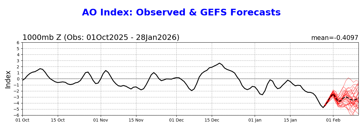
This storm was aligned with a spike in the AO which we usually want. Even so only gets to -2 which is probably aiding in the suppression.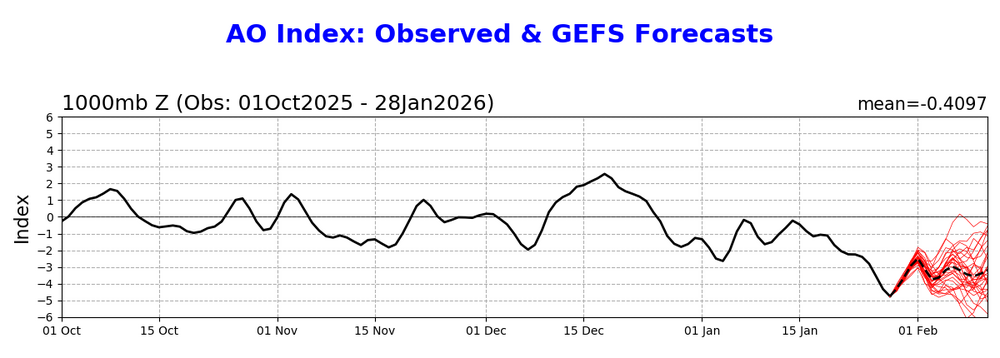
-
I thought I was going to move to Russia to get those totals, glad I am not an impulsive person. LOL.
-

Richmond Metro/Hampton Roads Area Discussion
RVASnowLover replied to RIC Airport's topic in Mid Atlantic
SREF looked great but I honestly don't know how accurate it is. -
Central PA Winter 25/26 Discussion and Obs
Blizzard of 93 replied to MAG5035's topic in Upstate New York/Pennsylvania
Low of 6 in Marysville -
7-8 across the area at 10:1 rates
-

Richmond Metro/Hampton Roads Area Discussion
eaglesin2011 replied to RIC Airport's topic in Mid Atlantic
KEY MESSAGE 1...While significant disagreement remains amongst the deterministic and ensemble guidance, confidence is high enough to warrant the issuance of a Winter Storm Watch for most of the CWA from late Friday night/early Saturday through Sunday afternoon. The main mode of disagreement continues to be the battle zone between drier air from the N/NW associated with a very strong area of high pressure (~1045 mb) over the Plains, and an intense low pressure system developing off the SE coast late Fri night/Sat. The GFS/GEFS is the NW outlier, wrapping significant amounts of moisture and QPF all the way into central VA, while the ECMWF/GEM are farther south and somewhat more suppressed with this moisture. The 00Z NAM is the opposite solution: almost completely dry other than in far southern VA and NE NC. One trend that continues in most of the models is a "piece" of the sfc high over the Plains ridging SE into the local area Friday into early Saturday, with low pressure across the eastern Gulf coast showing an inverted sfc trough extending north into the southern Appalachians. This has trended to an initial overrunning precip event (all snow) that could begin as early as Friday (but is more probably late Friday night through Saturday morning). For the piedmont, this portion of the storm may account for a majority of the snowfall. SLR values will be very high, 15:1 to 18:1 so even a relatively low amount of QPF could lead to a significant accumulation (which will be efficient on area roads given temperatures well below freezing). Still think the GFS is too far north with this feature (and keeps it maintained into Sat night even after the coastal low rapidly intensifies), so forecasted snow totals are well below what the GFS depicts over the NW 1/2 of the CWA. This is what really will make it or break it for most of our area.. -
It looks like we go back to a northern branch dominated pattern next month like we had in December
-

Possible coastal storm centered on Feb 1 2026.
40/70 Benchmark replied to Typhoon Tip's topic in New England
I agree the CTRV is probably dead, but we still have some hope. -
Possible coastal storm centered on Feb 1 2026.
40/70 Benchmark replied to Typhoon Tip's topic in New England
@Torch TigerI'm really not trying to be a weenie, but you have to be careful with convection and multiple lows. Believe me, I don't aim to look like an ass and hedge in the wrong direction, but sometimes it just works out that way. -

Possible coastal storm centered on Feb 1 2026.
CoastalWx replied to Typhoon Tip's topic in New England
Even 25 miles will help out. I don’t want to hype myself up for disappointment. -
.thumb.png.4150b06c63a21f61052e47a612bf1818.png)
Arctic Hounds Unleashed: Long Duration Late January Cold Snap
HIPPYVALLEY replied to WxWatcher007's topic in New England
I just did the pot of boiling water into the air trick for my wife and teenager. I could tell they were somewhat impressed, but also annoyed by my enthusiasm. -

E PA/NJ/DE Winter 2025-26 Obs/Discussion
MickeyTim6533 replied to LVblizzard's topic in Philadelphia Region
snooze fest