All Activity
- Past hour
-
I know a few
-

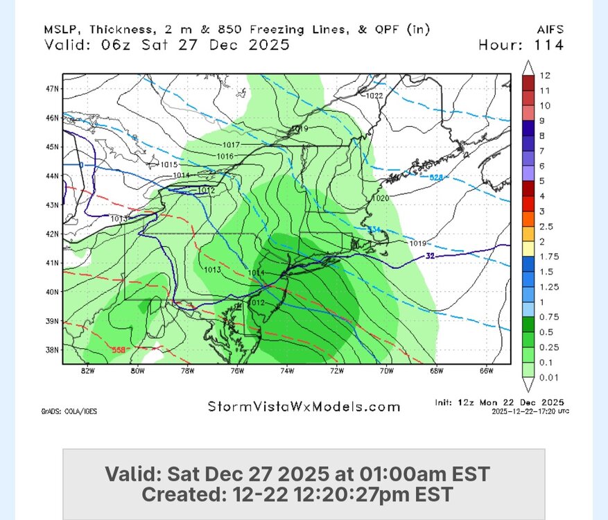
Snow Potential Dec 26-27
WestBabylonWeather replied to WeatherGeek2025's topic in New York City Metro
I want day after Xmas off can we have a nice little surprise -
Euro AI
-
i know a good lawyer who can help...
-
A lot of Baja lows in 12z. Wonder if we could kick one east.
-

Possible Light Snowfall (1" - 4") on Tuesday Dec 23
RU848789 replied to Northof78's topic in New York City Metro
Further improvement on the AIFS...I think most would take this and run, especially along 95. -

December 2025 regional war/obs/disco thread
RUNNAWAYICEBERG replied to Torch Tiger's topic in New England
Sucks for us here as Raymond has gotten more 20”+ events in nema than we have 12+ events. This area sucks for big ones…been 13yrs since the last true hecs. -

December 2025 Short/Medium Range Forecast Thread
Daniel Boone replied to John1122's topic in Tennessee Valley
That Block will either cause that northern plains/ Southern prairies LP to weaken and drift SE or shift South. -

White Christmas Miracle? December 23-24th
moneypitmike replied to Baroclinic Zone's topic in New England
Oh no they didn't...... ..WINTER STORM WATCH REMAINS IN EFFECT FROM TUESDAY AFTERNOON THROUGH WEDNESDAY AFTERNOON... * WHAT...Heavy snow possible. Total snow accumulations greater than 6 inches possible. Isolated amounts near one foot possible. -

Central PA Winter 25/26 Discussion and Obs
Boreal replied to MAG5035's topic in Upstate New York/Pennsylvania
Interesting snippet from Binghamton NWS AFD (issued prior to the 12z runs) Of particular note is the colder trend in the model guidance for Friday with the surface low track trending further to the south and a high to the north supplying colder air to the region. Should this trend continue, temperatures on Friday would be much colder than previously expected, with upper 20s to mid 30s for highs, rather than upper 30s to near 50 degrees for highs. In fact, the change from the 01Z NBM to the 07Z NBM shows this exact drastic difference. This would also mean snowier scenario for Friday, rather than a wintry mix to rain scenario. This will continue to be closely monitored with our upcoming forecast packages. -
December 2025 Short/Medium Range Forecast Thread
Daniel Boone replied to John1122's topic in Tennessee Valley
You have the maps listed opposite Larry. The bottom is 19th. -
Look at that SW trend! 2" in Baltimore as well!
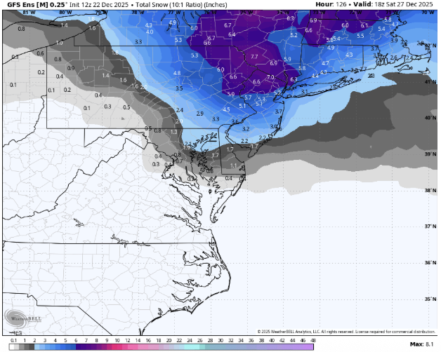
-

White Christmas Miracle? December 23-24th
WxWatcher007 replied to Baroclinic Zone's topic in New England
Beautiful vibe shift around here. Let’s bring it home. -

E PA/NJ/DE Winter 2025-26 Obs/Discussion
penndotguy replied to LVblizzard's topic in Philadelphia Region
I’ll sacrifice Rain over Ice any day, Especially .25 and over. -
Okay!!! Palisades did get very heavy snow last night and it did accumulate for them some, they look to have about 6-10 inches new snow on the ground! They may be about to get some more Tuesday!
-

White Christmas Miracle? December 23-24th
mahk_webstah replied to Baroclinic Zone's topic in New England
I still think up here that 3 inches is a win -
White Christmas Miracle? December 23-24th
mahk_webstah replied to Baroclinic Zone's topic in New England
Well, good. Maybe I’ll get it on a discount. -
The biggest impact of the - PNA if we actually keep blocking will be lack of STJ energy. We’ll be relying on something coming from the NW to dig and slow bc there won’t be enhancement or energy from the southern stream or a phase. That’s just the world we are in with the pacific this season. It can work for snow but the odds of a big coastal are muted without southern stream energy
-
He must be too scared to post. He keeps posting weenies on every post.
-

December 2025 regional war/obs/disco thread
Boston Bulldog replied to Torch Tiger's topic in New England
Euro has also shown that when you have less confluence for Friday, the follow up system cuts over the lakes as the trough can’t dig south. -
Also might have missed mention of it but the Ukie also moved south, still just some light mixy stuff for northern parts of the subforum though.
-

Occasional Thoughts on Climate Change
Typhoon Tip replied to donsutherland1's topic in Climate Change
https://phys.org/news/2025-12-climate-misinformation-national-threat-canada.html -
I want the full trifecta of my favorite sports teams in 2025: Hyde, Franklin, and Harbaugh. Burn it all down and salt the ashes.
-
White Christmas Miracle? December 23-24th
moneypitmike replied to Baroclinic Zone's topic in New England
New maps. -

Central PA Winter 25/26 Discussion and Obs
mahantango#1 replied to MAG5035's topic in Upstate New York/Pennsylvania
NWS changed their tune in temps and precipitation for Friday. Those 40s and 50s are gone!


