All Activity
- Past hour
-
I wouldn't completely rule out something even Weds or Thurs...one scenario is a slider w/ mostly rain. Another is a similar setup, but it backs the flow as the front passes. Might be room for a slp or weak wave to ride that front.
-
 Oh, I can tell you where the dry slot will be...just look at my screen name! lol
 -

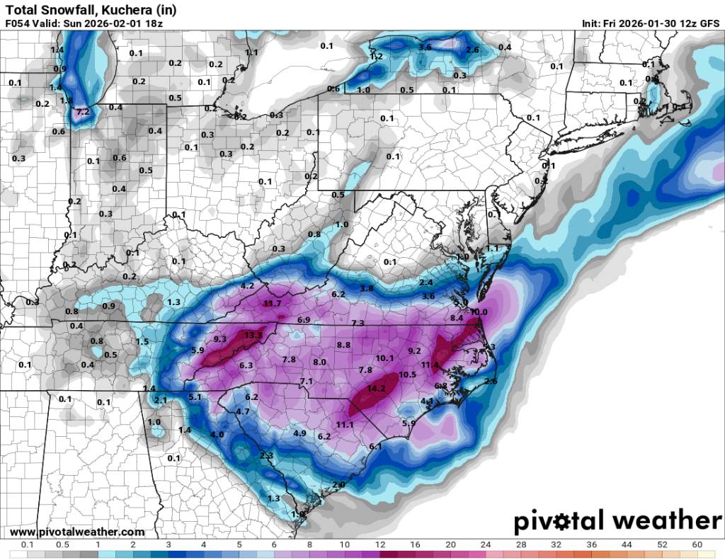
The “I bring the mojo” Jan 30-Feb 1 potential winter storm
SnowGoose69 replied to lilj4425's topic in Southeastern States
Inside this range go with the 3km NAM/Euro/RGEM...they're going to handle this better than the GFS. -
Still damn cold but too much of a breeze to have a chance at low single digits last night.
-
I hope to do better than 1 inch but this being the one time the NAM is correct wouldn't shock me. Earlier this winter one of the events it kept insisting I was getting 3-4 inches until the bitter end but I got about an inch. The Euro/RGEM gave me about an inch from that one. Here we have the opposite totals but the same models disagreeing.
-

The “I bring the mojo” Jan 30-Feb 1 potential winter storm
ADB83 replied to lilj4425's topic in Southeastern States
That’s my preferred method. Which is why I’m riding with the ICON from 3 days ago. I just toss all the runs from the other models, including all the ones from the ICON after my favorite run . -

February 2026 Medium/ Long Range Discussion: Buckle Up!
high risk replied to Weather Will's topic in Mid Atlantic
The mean has very limited value at this range, because a few snowy ensemble members can skew it. The probabilistic output is far more useful, but I'm not sure how easy it is to find that on the web. -
The GFS was a great run for eastern areas.
-

The “I bring the mojo” Jan 30-Feb 1 potential winter storm
Stormpc replied to lilj4425's topic in Southeastern States
And it pushes a little further north into Virginia giving us a little breathing room up north. -

Central PA Winter 25/26 Discussion and Obs
canderson replied to MAG5035's topic in Upstate New York/Pennsylvania
That hockey game in State College - good luck with that tomorrow. -

The “I bring the mojo” Jan 30-Feb 1 potential winter storm
eyewall replied to lilj4425's topic in Southeastern States
I accept this run -
The “I bring the mojo” Jan 30-Feb 1 potential winter storm
UpstateSCBud replied to lilj4425's topic in Southeastern States
This. Should be common knowledge by now -
We gonna run this back again next Saturday as well....0z GFS and Euro have a pronounced upslope event advertised???
-

E PA/NJ/DE Winter 2025-26 Obs/Discussion
Birds~69 replied to LVblizzard's topic in Philadelphia Region
Actually take this back. Looking at the beginning of the month, it was warmer than I remember so I guess top 26 is pretty decent.... -
(002).thumb.png.6e3d9d46bca5fe41aab7a74871dd8af8.png)
E PA/NJ/DE Winter 2025-26 Obs/Discussion
ChescoWx replied to LVblizzard's topic in Philadelphia Region
But in our current warm cycle it is quite amazing IMHO! -

The “I bring the mojo” Jan 30-Feb 1 potential winter storm
olafminesaw replied to lilj4425's topic in Southeastern States
Gorgeous. Almost the whole state at 6"+ -

The “I bring the mojo” Jan 30-Feb 1 potential winter storm
Upstate Tiger replied to lilj4425's topic in Southeastern States
Whichever is best for your backyard. -

February 2026 Medium/ Long Range Discussion: Buckle Up!
Weather Will replied to Weather Will's topic in Mid Atlantic
Pi It is a blend of previous runs so it is always a step behind. But I use it when I am only half watching to see if anything is going on... -

The “I bring the mojo” Jan 30-Feb 1 potential winter storm
BornAgain13 replied to lilj4425's topic in Southeastern States
So am I supposed to believe the GFS or the 3K NAM? -
A great run by the 12z gfs and along the border counties I think we see flow snow until Sunday morning. I think the models are cutting the flow off too soon. But a great run in general. Sent from my SM-G998U using Tapatalk

-
For reasons beyond me, the GFS/NAM have a major snow shadow over Southern Campbell County that suggest a downsloping effect off Cross Mountain, but I don't think the precip with this one is moving SW to NE like a typical system, but that's the direction of the drying it's trying to show. They often try that with traditional sliders where the precip is moving up from Alabama.
-

1-30/2-1-26 Arctic Blast, ULL Snow Event
Carvers Gap replied to John1122's topic in Tennessee Valley
I was thinking maybe around 2:00PM for TRI and also a friend of mine noted this as well. I would think Knoxville is a hair later than that - I hope so, because I have one commuting!!!! -

2025-2026 Fall/Winter Mountain Thread
franklin NCwx replied to Buckethead's topic in Southeastern States
And snowing hard in the teens! The ratios will be incredible later! -

February 2026 Medium/ Long Range Discussion: Buckle Up!
SomeguyfromTakomaPark replied to Weather Will's topic in Mid Atlantic
Is it just me or is this product virtually useless? Every time it gets posted in here it's like a crucial step behind the good models. -

Richmond Metro/Hampton Roads Area Discussion
eaglesin2011 replied to RIC Airport's topic in Mid Atlantic
Watch we will end up getting 1-3 tomorrow then 1-3 on Wednesday A nice little refresh of snow each time wouldn’t be the worst thing. Or Of course it could be nothing for the RVA area…lol