All Activity
- Past hour
-
It’s felt chilly today despite low-50s. Something felt different, crisp chill in the shade. Then I saw dews are in the 20s and I wonder if that’s it. Think this is the first afternoon with dew points in the 20s up here this season.
-
Carver. Very sorry for your loss.
-
Vikings fans excited about Odell Beckham being elevated from the practice squad?
-

Fall 2026 Medium/Long Range Pattern Thread
Matthew70 replied to John1122's topic in Tennessee Valley
We have had 1.25”. That will be gone by mid week with the heat back on. Drought brings forth more drought. Not liking the trends with the leaves starting to fall then add in lower humidity. -
That would be sweet to get 2" out here...just had a passing shower
-
Bring it, just ordered a new snowblower.
-
More cells developing in the clean air SW of Savannah need to be watched
-
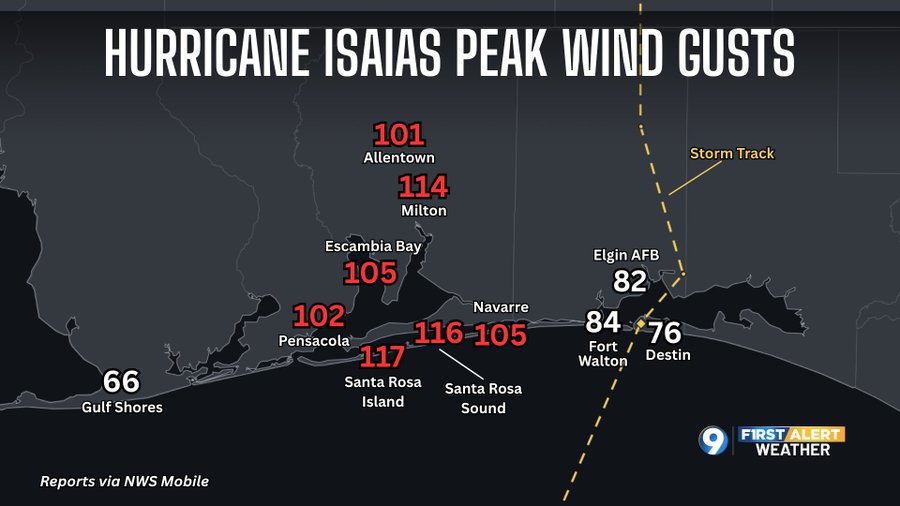
If we had gusts over 115, IMO it was definitely Cat 2 as it came ashore.
-
Yup. I'm in the same range. We need it, though.
-

Fall 2026 Medium/Long Range Pattern Thread
jaxjagman replied to John1122's topic in Tennessee Valley
Not very impressed,the dry air getting funneled into this storm, much more than what the models have been showing,Southern MID Tn did quite well tho,was hoping for more rain here -
Very serious, longtracked (been going 1 hour+!!) violent tornado moving N at 25 toward Allendale Cty of SC: BULLETIN - EAS ACTIVATION REQUESTED TORNADO WARNING NATIONAL WEATHER SERVICE CHARLESTON SC 340 PM EDT SAT OCT 10 2026 THE NATIONAL WEATHER SERVICE IN CHARLESTON HAS ISSUED A * TORNADO WARNING FOR PORTIONS OF... SCREVEN COUNTY IN SOUTHEASTERN GEORGIA... ALLENDALE COUNTY IN SOUTHEASTERN SOUTH CAROLINA... * UNTIL 415 PM EDT. * AT 340 PM EDT, A CONFIRMED TORNADO WAS LOCATED 7 MILES NORTHEAST OF HUNTERS, MOVING NORTH AT 25 MPH. HAZARD...DAMAGING TORNADO. SOURCE...WEATHER SPOTTERS CONFIRMED TORNADO. IMPACT...FLYING DEBRIS WILL BE DANGEROUS TO THOSE CAUGHT WITHOUT SHELTER. MOBILE HOMES WILL BE DAMAGED OR DESTROYED. DAMAGE TO ROOFS, WINDOWS AND VEHICLES WILL OCCUR. TREE DAMAGE IS LIKELY. * LOCATIONS IMPACTED INCLUDE... BURTONS FERRY LANDING AND MILBURY.
-
Very serious, longtracked (been going 1 hour+!!) violent tornado moving N at 25 toward Allendale Cty of SC: BULLETIN - EAS ACTIVATION REQUESTED TORNADO WARNING NATIONAL WEATHER SERVICE CHARLESTON SC 340 PM EDT SAT OCT 10 2026 THE NATIONAL WEATHER SERVICE IN CHARLESTON HAS ISSUED A * TORNADO WARNING FOR PORTIONS OF... SCREVEN COUNTY IN SOUTHEASTERN GEORGIA... ALLENDALE COUNTY IN SOUTHEASTERN SOUTH CAROLINA... * UNTIL 415 PM EDT. * AT 340 PM EDT, A CONFIRMED TORNADO WAS LOCATED 7 MILES NORTHEAST OF HUNTERS, MOVING NORTH AT 25 MPH. HAZARD...DAMAGING TORNADO. SOURCE...WEATHER SPOTTERS CONFIRMED TORNADO. IMPACT...FLYING DEBRIS WILL BE DANGEROUS TO THOSE CAUGHT WITHOUT SHELTER. MOBILE HOMES WILL BE DAMAGED OR DESTROYED. DAMAGE TO ROOFS, WINDOWS AND VEHICLES WILL OCCUR. TREE DAMAGE IS LIKELY. * LOCATIONS IMPACTED INCLUDE... BURTONS FERRY LANDING AND MILBURY.
-
URGENT - WINTER WEATHER MESSAGE National Weather Service Great Falls MT 1056 AM MDT Sat Oct 10 2026 MTZ307-308-315-316-111200- /O.CON.KTFX.WS.W.0008.261010T1800Z-261012T1200Z/ Southern Rocky Mountain Front-Southern High Plains-Upper Blackfoot and MacDonald Pass-Gates of the Mountains- Including the cities of Pendroy, Flesher Pass, MacDonald Pass, Craig, Rogers Pass, Bynum, Lincoln, Canyon Creek, Wolf Creek, Marysville, and Choteau 1056 AM MDT Sat Oct 10 2026 ...WINTER STORM WARNING REMAINS IN EFFECT UNTIL 6 AM MDT MONDAY... * WHAT...Heavy, wet snow expected. Total snow accumulations between 10 and 20 inches, with the exception of the Lincoln valley where up to 7 inches is expected. Isolated amounts approaching 30 inches within the Bob Marshall Wilderness. Winds gusting as high as 45 mph. * WHERE...Gates of the Mountains, Upper Blackfoot and MacDonald Pass, Southern High Plains, and Southern Rocky Mountain Front. * WHEN...Until 6 AM MDT Monday. * IMPACTS...Travel could be very difficult. Gusty winds combined with the wet and heavy nature of the snow could bring down tree branches. Isolated power outages are possible. * ADDITIONAL DETAILS...Snowfall amounts will vary drastically from grassy surfaces to roadways, most notably at lower elevations, with accumulations on non-grassy surfaces being confined mainly to between the evening through late morning hours.
-
Silver lining was the storm moved so fast, many places probably ended up with half the forecasted rain.
-
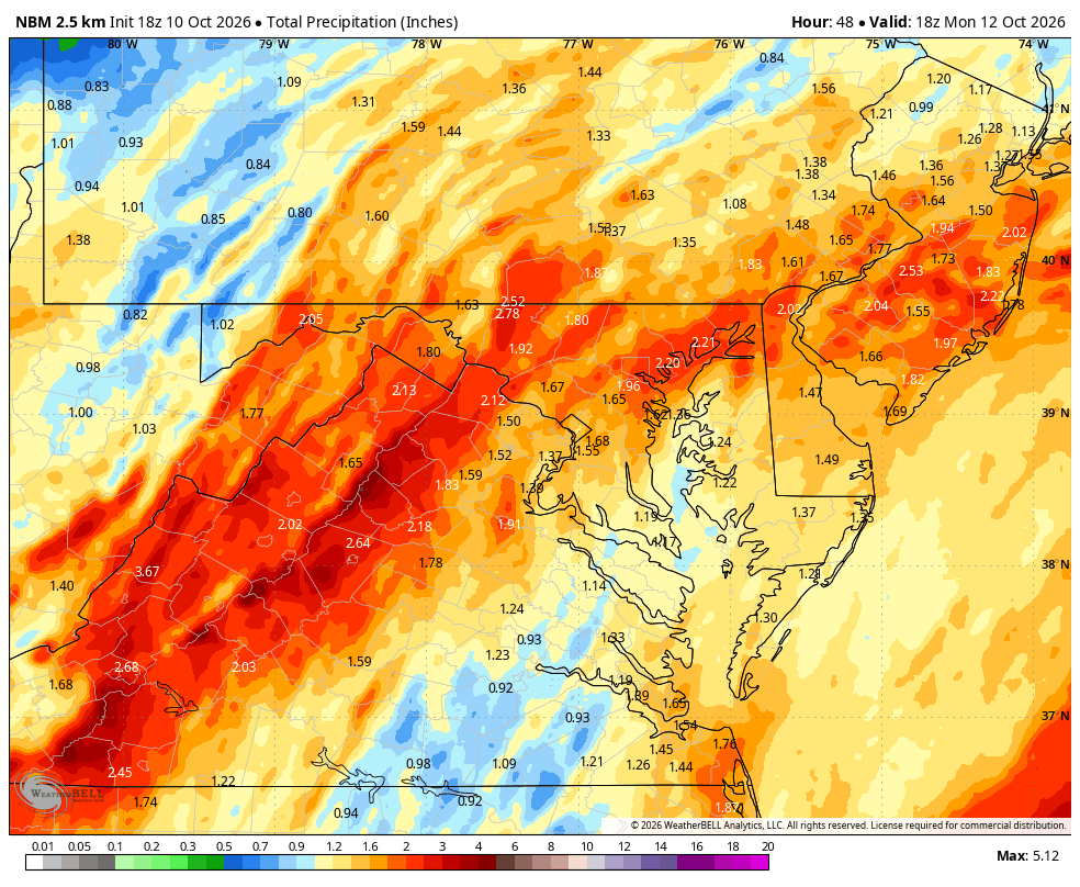
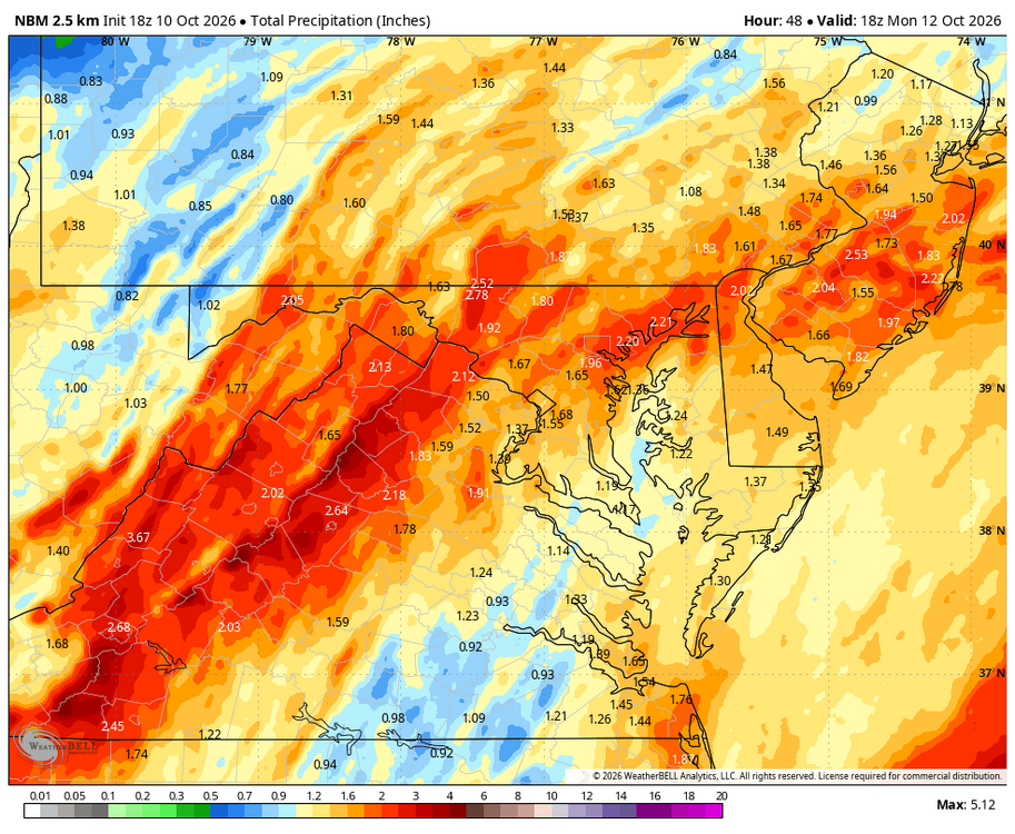
WB 18Z NBM
-
I just seen the NWS upped the rain totals 1.25 to 2.50 tomorrow.
-
-

Mid-Long Range Discussion 2026
WinstonSalemArlington replied to BooneWX's topic in Southeastern States
-
 semaglutide without insurance: SemaOral Direct - how to speed up weight loss on semaglutide?
 -

2026-2027 Record-breaking El Nino
rclab replied to Stormchaserchuck1's topic in Weather Forecasting and Discussion
Caution …… forky …… incoming …… as always ….. -
Ugliest game I’ve laid my eyes on
-
Enjoying this slogfest up there in Boone? LOL Baseball score of 3-2 right now. Go App!
-
1.63
-
Sign me up for a guaranteed regionwide 1.5" - 2.5" of rain.
- Today
-

2026-2027 Fall/Winter Mountain Thread
franklin NCwx replied to BlueRidgeFolklore's topic in Southeastern States
Thats what came through here around 11am