All Activity
- Past hour
-
1002mb usually isn't well defined. The Euro is not really showing much deepening until tomorrow morning. It probably becomes a hurricane tomorrow evening and a major by Sunday afternoon.
-
There have been only 6 (13%) sub -0.25 NAOs averaged over DJF since 1980 and they were all within ~2 years of a sunspot cycle minimum: 1984-5, 1986-7, 1995-6, 2009-10, 2010-1, and 2020-1. Being that this autumn has been in a persistent very active sunspot period after the peak only about a year ago, 2025-6 will still be during a mainly active sunspot period. As we get out to 2028-9 and going into the early 2030s, we should then be within ~2 years of the next cycle min. Therefore, based on the last 45 winters and assuming that pattern continues, ~2028-9 should be the next winter with a good shot at a sub -0.25 NAO averaged out. Hopefully like was the case in the mid-1980s and 2009-1, we’ll get two -NAO winters between 2028-9 and ~2031-2
-
Yeah, I think virtually nowhere outside of the mountains got nearly as cold as predicted this morning. Burlington got down to 37 though.
-
No matter how far southwest it tracks, it turns right back over Jamaica.
-
I don't know if I would describe that LLC as well defined. It still looks messy and very elongated to me based on satellite and recon data, but better than yesterday.
-
Sunny start to the day here, but based on the satellite loop, the Catoctin crew should not get too comfortable with the blue skies.
-
There was a very unusual WWB in the far EPac in March '23 that was very strong. That started Costero conditions pretty early and may have helped contribute to an earlier response (a la 1877-78). Aerosol loading dropouts after '20 didn't help either -- unmasked pretty quickly after the end of the triple-dip Nina. I still expect some retracement from here through March/April, but if we don't get meaningful drops, that in itself will be pretty telling.
-
Their winter forecast is similiar to others on social media in regards to this winter. Weak La Nina , alot of snow cover up north and a greater chance of a negative NAO.
-
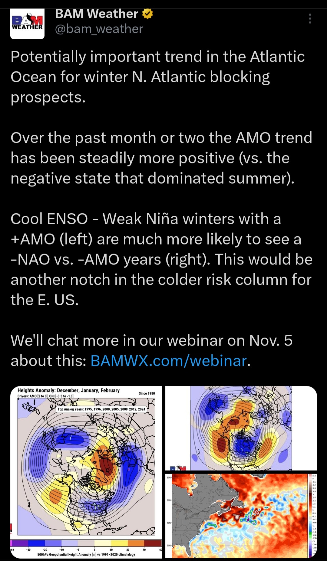
The AMO never went negative this summer. More ridiculous hype and clickbait for subscription money from those clowns. Nice New Foundland warm pool too, which is actually supportive of -NAO’s linking up with the WAR/SE ridge @donsutherland1
-

Spooky Season (October Disco Thread)
tamarack replied to Prismshine Productions's topic in New England
Sapling oaks are reddish brown while the 24" by 90 ft oak is yellow-brown, also fully turned and about 25% leaf drop. Other than the oaks, only the understory beech have significant leaves among the deciduous trees. They'll be the last to drop, some hanging on into spring. Thick frost this morning, 29-30°. Oct 24 average is 52/32 so today should finish near to that. -
First morning in the 30s at 39.6. Light frost in the favored lower elevation neighborhood spots.
-
-

-

Central PA Fall Discussions and Obs
WmsptWx replied to ChescoWx's topic in Upstate New York/Pennsylvania
It's snowing on Seven Springs -
If the MJO fails to propagate past phase 6/7 and ends up re-emerging back in the IO, which some models are showing now, then another run of strong -AAM becomes a very distinct possibility once we get into November
-
Has to be the lake or did the breeze keep going?
-
.thumb.png.4150b06c63a21f61052e47a612bf1818.png)
Spooky Season (October Disco Thread)
HIPPYVALLEY replied to Prismshine Productions's topic in New England
Probably want to start with something like this:
-

Spooky Season (October Disco Thread)
Damage In Tolland replied to Prismshine Productions's topic in New England
Oaks are about 50% naked here -

Spooky Season (October Disco Thread)
TauntonBlizzard2013 replied to Prismshine Productions's topic in New England
They just reported 14” -
Most spots should finish warmer than average but the cooler spots like LGA, BDR, and NYC should finish below. October departures through the 23rd EWR….+2.5 NYC…..+1.4 JFK……+1.8 LGA……+0.8 HPN……+2.9 ISP……..+3.3 BDR…..+0.4 New Haven….+3.8 New Brunswick…+2.3
-
Insane. Stalled at 42 and never went further.
-
06z Google.... almost all tracks now over Jamaica.

-
Hi all, MD Climate Bulletin for September 2025 follows: "We are pleased to share the Maryland Climate Bulletin for September2025, which includes sea surface temperatures for the Chesapeake Bayand the state's coastal waters. However, due to the ongoing federalgovernment shutdown, the availability of the main data source we usefor the Bulletin has been affected. The regular production of thebulletin is only possible thanks to the hard work and data provided byour friends at NOAA National Centers for Environmental Information,the CoastWatch East Coast Node, the Institutions involved in the U.S.Drought Monitor, and the U.S. Geological Survey's Water Watch.You can access the Bulletin from the following link:https://mdsco.umd.edu/Bulletin/bulletin_mdsco_current.pdfPoints to highlight are:1) Statewide averages indicate that September 2025 was warmer anddrier than normal (i.e., 1991-2020 averages).2) Regionally, the mean temperature was warmer than normal over themajority of the state. Warmer-than-normal anomalies appeared over thenorthern half of the state, especially over parts of Carroll,Frederick, and Washington counties (around 1.0°F). Colder-than-normalconditions appeared over the southern counties to both sides of theBay, particularly over Charles County (around 1.0°F below).3) Precipitation was below normal for the majority of the state,notably over Frederick and Washington counties (2.0 to 3.0 inchesdeficit), and over Garrett, Allegany, Carroll, Montgomery, Howard,Baltimore, Harford, Cecil, Charles, and Prince George’s counties (1.0to 2.0 inches deficit). Above normal precipitation appeared over someareas in the Eastern Shore, over Queen Anne’s, Kent, and Worcestercounties (larger than 2 inches), as well as over portions ofDorchester and Wicomico counties (1.0 to 2.0 inches). The first ofthese regions, over the western states, received 25 to 50% lessprecipitation than normal, while the regions in the Eastern Shore got25 to 50% more precipitation than normal for the month.4) Drought conditions intensified in September, primarily in thewestern counties. While the extent of the state affected by droughtdiminished from 70% to 50%, Moderate Drought conditions affectedGarrett, Allegany, and Washington counties along the limits with WestVirginia, as well as western and central Montgomery County. SevereDrought conditions also developed over the western counties, and evenExtreme Drought conditions started to creep over the southern tip ofGarrett County. The rest of these counties were under Abnormally Dryconditions, which also affected Frederick, Carroll, Baltimore, Howard,Prince George’s, Charles, Calvert, Saint Mary’s, and Caroline. Severalstreams and rivers in the Piedmont and western Maryland hadBelow-normal streamflow, with a few experiencing Much-below-normalstreamflow.5) The Chesapeake Bay sea surface temperatures (SST) in September 2025ranged between 73 and 78°F, marking the second consecutive month theyremained below their 2007–2020 mean across the entire region. Adistinct north-to-south gradient defined the magnitude of the coldanomalies. The most significant deficit (3–4°F below average) wasrecorded in the southeastern Lower Bay, encompassing Tangier Soundwaters off Somerset, Wicomico, and Dorchester counties. Movingnorthward, along the coasts of Talbot and Queen Ann counties up toEastern Bay, the anomalies lessened to 2–3°F below the mean. Thewaters off Kent and Baltimore counties and farther northward in theUpper Bay, showed the smallest cold anomalies (1–2°F below).Chincoteague Bay temperatures were also notably colder than normal(2–3°F below). The all-basin mean temperature of 74.0°F was stillwarmer than the coldest September in the 19-year dataset (2007-2025),which recorded 72.8°F in 2009.Please refer to the bulletin for more details. The bulletin is issuedonce per month and shows the state's recent monthly surfacetemperature and precipitation conditions in a simple format, helpingMarylanders better understand regional climate variations.Please help disseminate this bulletin.Thanks,Alfredo.............................................Alfredo Ruiz-Barradas, PhDAssociate Research ProfessorMaryland State Climatologist"
-
No. The long-duration block should provide just enough cool weather to result in a modest cool anomaly for October.
- Today
-

Spooky Season (October Disco Thread)
CT Valley Snowman replied to Prismshine Productions's topic in New England
Down to 33 this morning with areas of frost.