All Activity
- Past hour
-
(002).thumb.png.6e3d9d46bca5fe41aab7a74871dd8af8.png) Mike, I'll take your four questions in order Q1 - yes. Raw records could potentially carry non-climatic biases that don't cancel but not always! Q3 - yes. Williams 2012, Venema 2012 and Killick 2022 are real, adversarial, and they show homogenisation reduces error if a station has proven data issues, I accept that and I'm not going to pretend the literature says otherwise. Q2 - one correction. You say breakpoint detection is "even unstable run-to-run (shown in this thread's own evidence)." It wasn't shown. I went looking for it: two pulls of the West Chester QCF taken a few years apart were identical across all 119 complete years, unadjusted series identical too. NCEI told me the output can change daily; I tested it and found none over that interval. That concession isn't mine to accept. Q4 is where we really differ, and it's about scope. My claim is narrower: the specific magnitudes applied to specific Chester County stations haven't been independently verified, and showing an event occurred doesn't verify the size of the correction attached to it. The benchmarks measure whether homogenisation moves a NETWORK closer to truth on average - the right quantity for a national series, and a different question from whether one station in one decade got the right number. Venema's own write-up notes it modelled small European networks at high station density without network-wide trend biases; Williams found improvement in the presence of widespread systematic errors. Both are aggregate statements under stated conditions. The conditions matter here. Before 1951 this county has three continuous stations. Menne and Williams say it themselves in the 2009 paper: false alarms at neighbouring stations reduce the number of homogeneous neighbours and thereby prevent the estimation of adjustments. That's the sparse-network failure mode described by the algorithm's own authors, in the era carrying the largest adjustments. On cherry-picking - you introduced Coatesville as the exemplar and called it two resounding yeses. If it's representative enough to validate, it's representative enough to examine. You asked for a case. Here's the beginning of one, and it's a magnitude test rather than an occurrence test. So I built a regional reference for Coatesville from the raw, unadjusted Chester County records only - leaving Coatesville 1SW out so that it never contributes to its own comparator, and no homogenised product anywhere in the calculation. Measured drift of Coatesville against those raw neighbours over 1895-1982 is -0.190 F/decade using every available station, or -0.113 F/decade using a fixed panel that can't change membership. The applied NCEI adjustment runs +0.303 F/decade, which implies a drift of -0.303. That value falls outside the 95% confidence interval of the measured drift under both reference constructions. The adjustment also tracks the drift year to year - r = -0.74 - so it's aimed at something real. It's the size I'm questioning, not the existence. What this is so far in all of my multiple years of review which has been my analytic goal of this process of reviewing the adjustment of raw data at one targeted station Coatesville 1SW is that the correction appears larger than the divergence it corrects, measured without using any homogenised data. If that's wrong I'd like to know how?? Paul
Mike, I'll take your four questions in order Q1 - yes. Raw records could potentially carry non-climatic biases that don't cancel but not always! Q3 - yes. Williams 2012, Venema 2012 and Killick 2022 are real, adversarial, and they show homogenisation reduces error if a station has proven data issues, I accept that and I'm not going to pretend the literature says otherwise. Q2 - one correction. You say breakpoint detection is "even unstable run-to-run (shown in this thread's own evidence)." It wasn't shown. I went looking for it: two pulls of the West Chester QCF taken a few years apart were identical across all 119 complete years, unadjusted series identical too. NCEI told me the output can change daily; I tested it and found none over that interval. That concession isn't mine to accept. Q4 is where we really differ, and it's about scope. My claim is narrower: the specific magnitudes applied to specific Chester County stations haven't been independently verified, and showing an event occurred doesn't verify the size of the correction attached to it. The benchmarks measure whether homogenisation moves a NETWORK closer to truth on average - the right quantity for a national series, and a different question from whether one station in one decade got the right number. Venema's own write-up notes it modelled small European networks at high station density without network-wide trend biases; Williams found improvement in the presence of widespread systematic errors. Both are aggregate statements under stated conditions. The conditions matter here. Before 1951 this county has three continuous stations. Menne and Williams say it themselves in the 2009 paper: false alarms at neighbouring stations reduce the number of homogeneous neighbours and thereby prevent the estimation of adjustments. That's the sparse-network failure mode described by the algorithm's own authors, in the era carrying the largest adjustments. On cherry-picking - you introduced Coatesville as the exemplar and called it two resounding yeses. If it's representative enough to validate, it's representative enough to examine. You asked for a case. Here's the beginning of one, and it's a magnitude test rather than an occurrence test. So I built a regional reference for Coatesville from the raw, unadjusted Chester County records only - leaving Coatesville 1SW out so that it never contributes to its own comparator, and no homogenised product anywhere in the calculation. Measured drift of Coatesville against those raw neighbours over 1895-1982 is -0.190 F/decade using every available station, or -0.113 F/decade using a fixed panel that can't change membership. The applied NCEI adjustment runs +0.303 F/decade, which implies a drift of -0.303. That value falls outside the 95% confidence interval of the measured drift under both reference constructions. The adjustment also tracks the drift year to year - r = -0.74 - so it's aimed at something real. It's the size I'm questioning, not the existence. What this is so far in all of my multiple years of review which has been my analytic goal of this process of reviewing the adjustment of raw data at one targeted station Coatesville 1SW is that the correction appears larger than the divergence it corrects, measured without using any homogenised data. If that's wrong I'd like to know how?? Paul -

Invest 94L—30% 2 day and 50% seven day odds of development
GaWx replied to WxWatcher007's topic in Tropical Headquarters
0Z UKMET: ends up N of PR as a TD moving WNW:NEW TROPICAL CYCLONE FORECAST TO DEVELOP AFTER 108 HOURSFORECAST POSITION AT T+108 : 17.1N 56.8WLEAD CENTRAL MAXIMUM WINDVERIFYING TIME TIME POSITION PRESSURE (MB) SPEED (KNOTS)-------------- ---- -------- ------------- -------------1200UTC 18.08.2026 108 17.1N 56.8W 1013 240000UTC 19.08.2026 120 18.4N 58.3W 1014 251200UTC 19.08.2026 132 19.2N 60.4W 1014 260000UTC 20.08.2026 144 20.0N 62.1W 1015 271200UTC 20.08.2026 156 20.6N 64.3W 1015 280000UTC 21.08.2026 168 21.4N 67.0W 1014 28 -
2026-2027 Record-breaking El Nino
BlizzardWx replied to Stormchaserchuck1's topic in Weather Forecasting and Discussion
For an el nino summer, we've sure been cooking in the south lately, and it looks like a week or more of 100+ temps coming. Very unusual for el nino from my understanding...but I still think once we get more into fall the STJ will increase with angular momentum working north. -
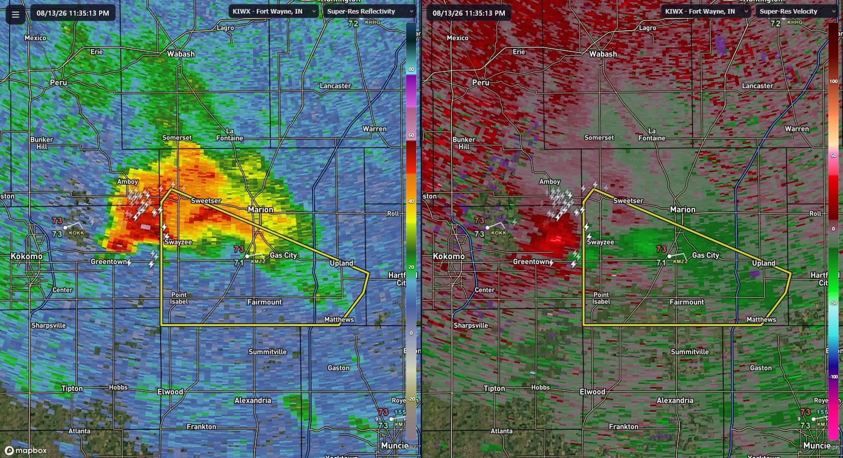
Fort Collins could have seen a lot of lightning bolts from this one
-
 http://mexisaferx.com/# mexico prescriptions
 -
-
yeah you're in a great spot, looks like a nice light show if nothing else.
-
Yeah, been watching it from my back porch. It just started moving right. Wind here abruptly changed direction about 15 min ago like 180 degrees heading into that thing. Got my eyes on the one behind it. Its freaking juicy as hell out.
- Today
-
Today's Highs: PHL: 90 New Brnswck: 89 EWR: 88 JFK: 88 ACY: 88 BLM: 88 TEB: 86 LGA: 86 TTN: 86 NYC: 5 ISP: 85
-
things that make you go hmmmmm
-

Augdewst 2026: Summer's Last Stand
tunafish replied to Prismshine Productions's topic in New England
Interesting, thank you. Definitely had that extra bite. I'm also happy the hail spared the gardens and plants for the most part. -
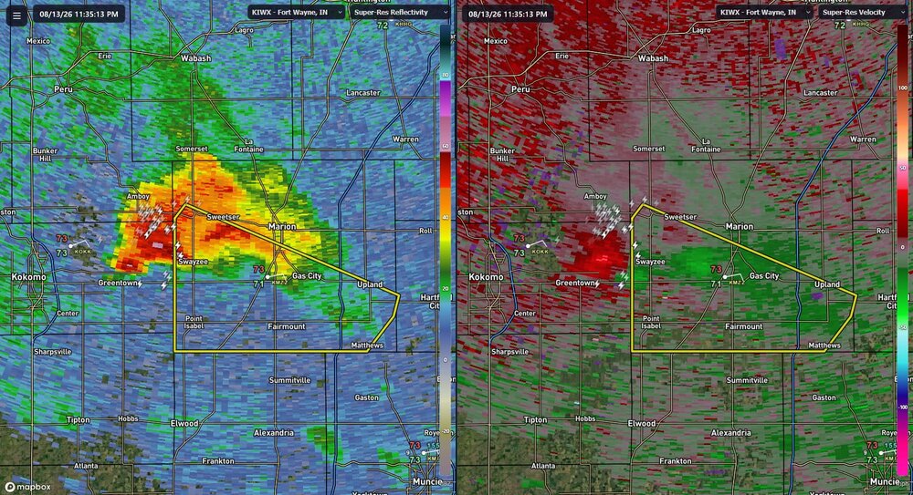
convection blowing up over northern IL and IN again
-
Looks like I mis-timed our trip by a week to get some tropical action. Hopefully nothing too serious there for Alex.
-
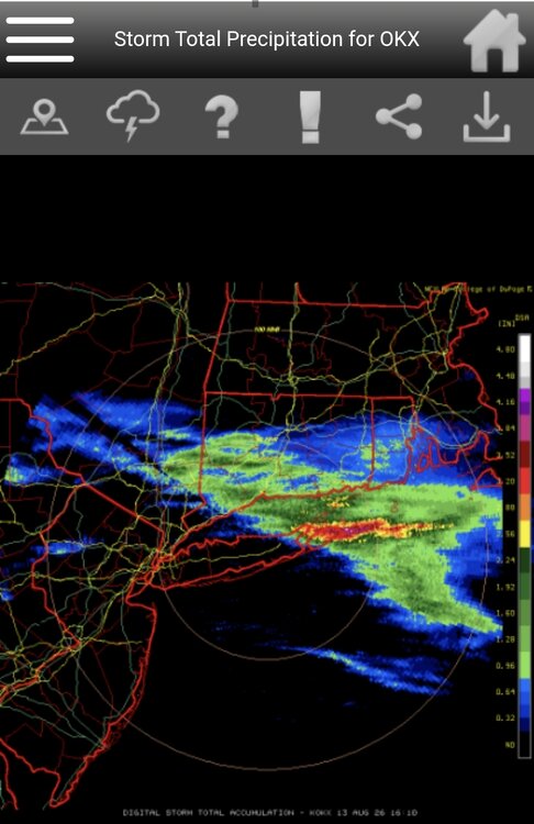
Crushed. Both forks. Heard a lot of thunder in the middle of the night here, but zero rain.
-
This has been an impressively consistent stretch of humidity.
-
https://trustpharmaindia.com/# world pharmacy india
-
Yep! I’ve seen erupting a few years ago when the lava was flowing into the ocean - cool, but this was another level
-

Augdewst 2026: Summer's Last Stand
OceanStWx replied to Prismshine Productions's topic in New England
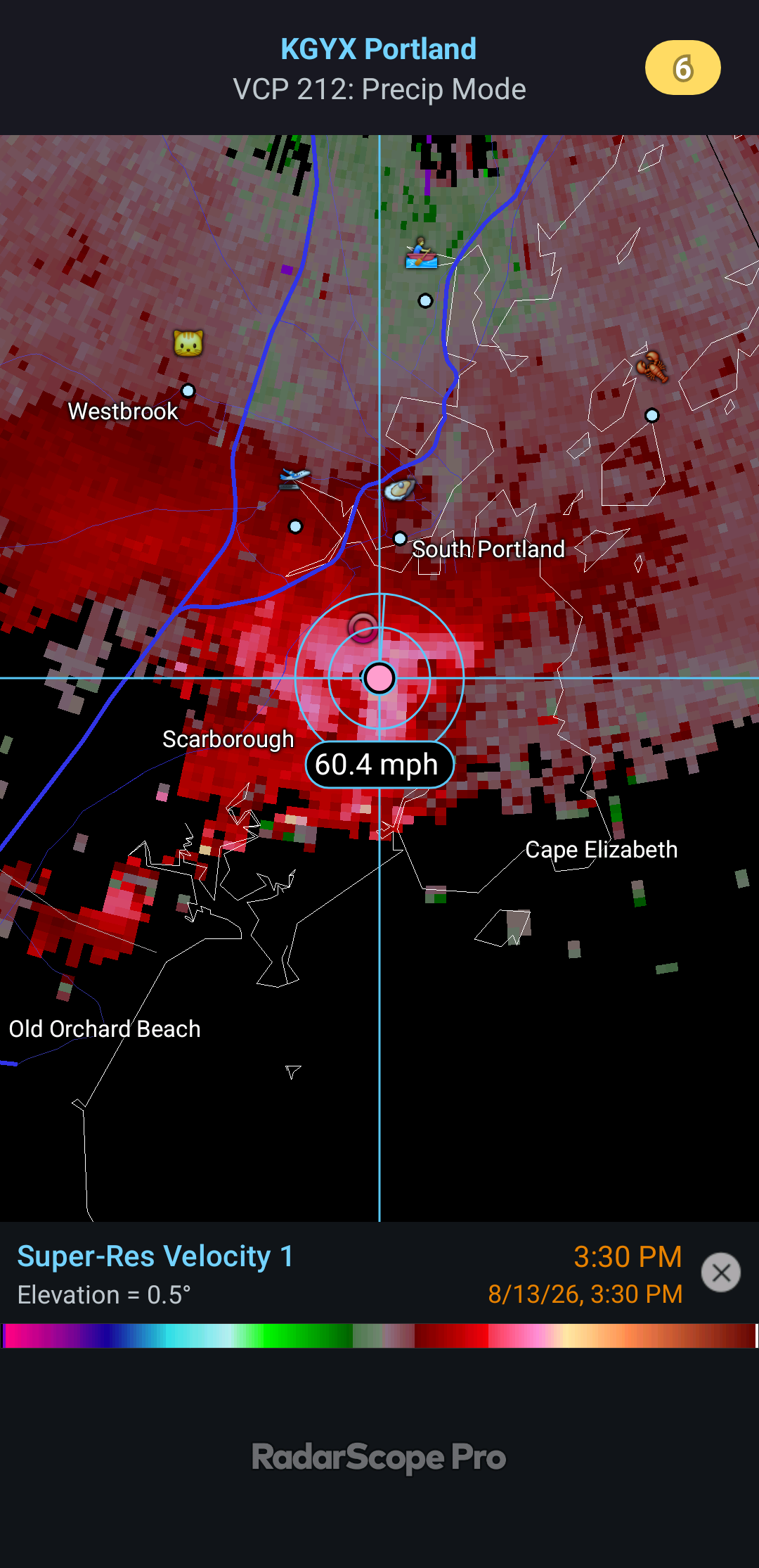
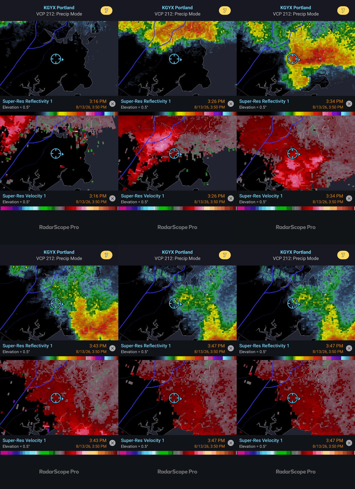
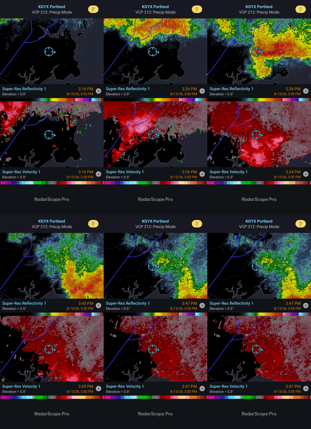
Big boy wind. You can see what a mess wind like this going through a forest would make when trying to figure out if it is tornadic or not. On the velocity front, keep in mind that it is radial velocity, so some component of that wind was not being sampled since it was not directly parallel to the radial. I would say 60 mph would be the lower bound of the estimated wind. -
 Paul, you need to find a case where you can show PHA failed, and more generally, show that PHA is a bad approach. The burden is on you to show that the station was incorrectly adjusted, not on me to walk you through the variables a Newlinville. Here is a quick review of where we are at on your 2 year old thread: Q1 — Is it necessary to adjust raw data before use for climate trends/model inputs? Yes. Raw records carry known, non-climatic biases (station moves, instrument changes, time-of-observation changes, site changes) that don't cancel out and will systematically distort trends if left uncorrected. Q2 — Is it perfect? No. Breakpoint detection is demonstrably imperfect and even unstable run-to-run (shown in this thread's own evidence), and the method is explicitly statistical inference, not direct measurement. Q3 — Is it pretty good, and has it undergone rigorous review/testing for over a decade? Yes to both. Multiple independent blind benchmarks (Venema 2012, Williams 2012, Killick 2022) show it reduces error relative to known synthetic ground truth, and it's been continuously re-tested and refined for over 15 years, including by critics actively trying to find its weak points Q4 — Given all that, does a cherry-picked local anomaly (minor adjustments at Newlinville era) amount to a valid attack on the process? No. A single, non-representative case can't outweigh a decade-plus of adversarial, blind-tested evidence — however carefully that one case is analyzed.
 -
Augdewst 2026: Summer's Last Stand
tunafish replied to Prismshine Productions's topic in New England
Not sure I'll experience a thunderstorm better than today's storm - at least not IMBY. I've never seen wind like that, not from a t-storm. Plus 0.96" in 13 minutes. Legit white out at times. Lots of massive oaks and pines down around town, and fortunately most were not on cars or homes. Half were uprooted and half were just snapped off at the base. Not sure how accurate RadarScope is with estimated velocity, but 60-65 mph smells in the ballpark. Power out about 6 hrs. Some phil from local news.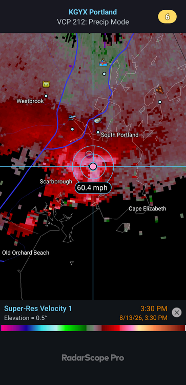
-
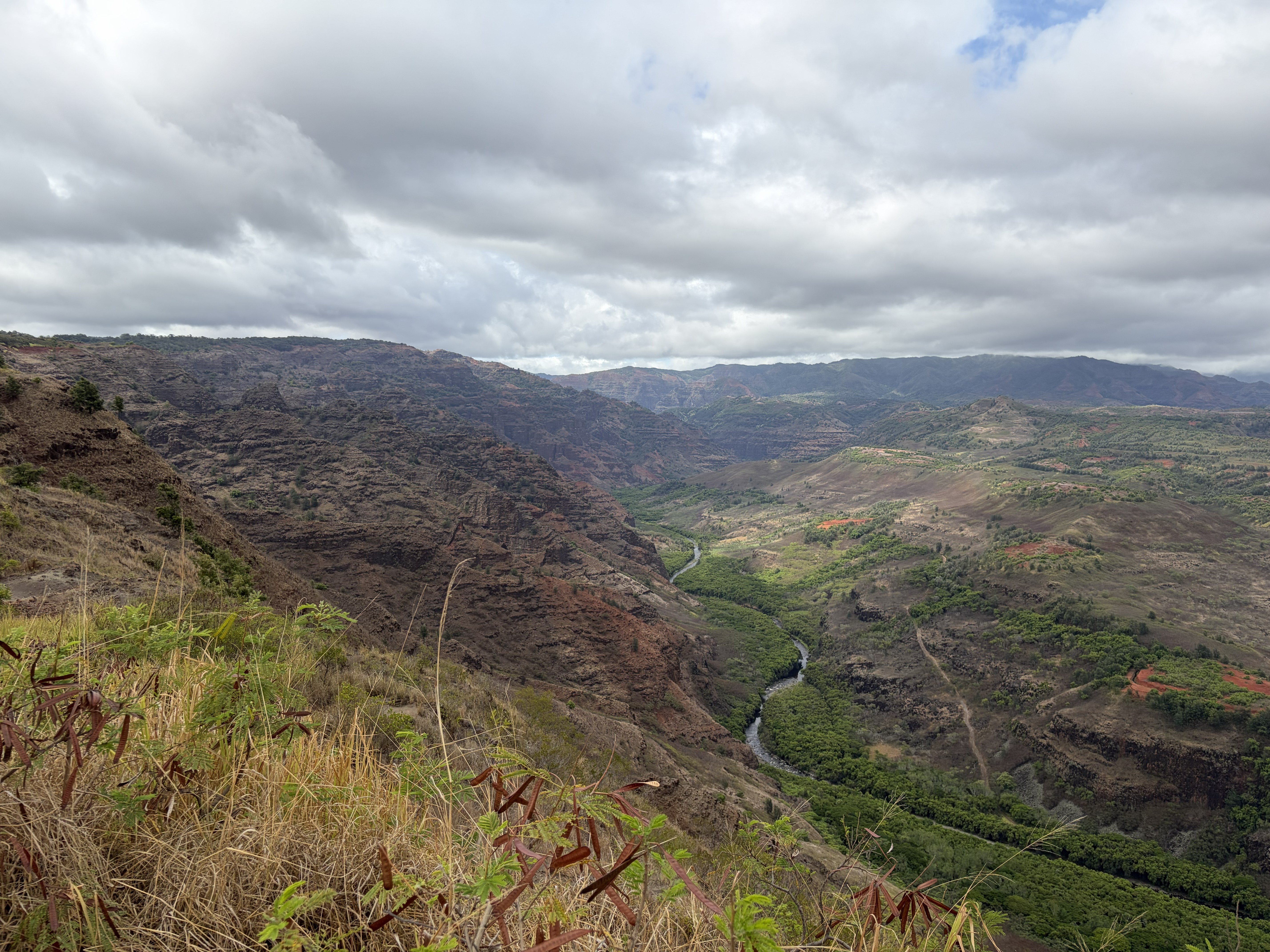
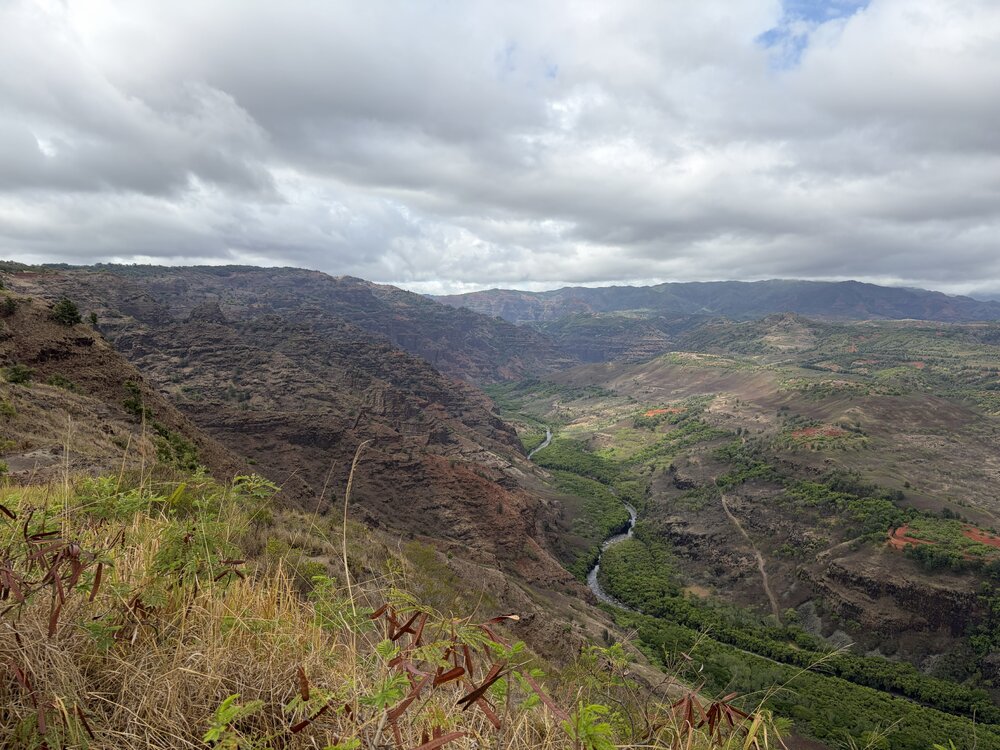
Nice. Spent two weeks there. We were staying in Princeville on the north shore but did take a ride to Waimea one day. Didn't go far into the canyon due to time but that's a nice area.
-
Just keep it hot and humid until Sept 12th, when I get back from the beach. Then we can cool off for good.
-
Spring/Summer 2026 Pattern Discussion Thread
1234snow replied to Carvers Gap's topic in Tennessee Valley
Yep 3rd straight evening under a severe thunderstorm warning. -

2026-2027 Record-breaking El Nino
michsnowfreak replied to Stormchaserchuck1's topic in Weather Forecasting and Discussion
I think thats a reasonable take. Especially for the coast, its not like December is prime winter normally anyway, much less in a strong nino. @roardog @LakePaste25 and other Great Lakers. @40/70 Benchmark i know you dont forecast for the Lakes. I dont "forecast" at all but with all the discussion to date I can envision the season playing out something like this in SE MI- we get a good winter blast in mid or late November (hopefully Thanksgiving time) with well below avg temps and snow (probably synoptic and lake- watch out lake belts). Then December sees that late Fall vibe return. Not "warm", but more murky mild and Novembery. It will snow, but with the mild days handily outnumbering the cold ones will need some luck and good timing or else Decembers wintry opportunities may be limited to mood flakes and snow squalls. January and February is when its game on but we will have two different scenarios to worry about. Scenario 1- the warmer strong nino outcome. More mild days. This also increases our odds bigtime of those dynamic wet snowstorms (think Jan/Mar 2023). But with those odds you still have to worry about storm track, plus you lose a lot of the daily mood flakes/light snows you get most winters. Scenario 2- the colder outcome models hint at. This is good for a more traditional winter feel, but too much of this could be cold and dry (moreso MI and west, not so much LakePaste territory). Winters like 1957-58 & 1965-66 that east coasters salivate over were boring as hell here, cold and dry with very light snowfall. We did at least have a light 1-3" snowcover each time for all the cold, but id imagine id be pulling my hair out as multiple storms hit the east. (Closest ive come to that was 1995-96 but even that was better than '58 or '66). Personally I dont think its happening, at least to that extent. If the cold wins, I think we see much more snow than '58 or '66 (not necessarily above avg, just more than those pitiful years). We've had two winters in a row where snowcover and cold "outpaced" snowfall, cant imagine 3 in a row. March- most of us are well overdue for a good March and early outlooks agree. I expect a good snowstorm this month. And if the rest of winter is lighter on snowfall, I can almost guarantee it. -

Central PA Summer 2026 Discussion/Obs Thread
canderson replied to Voyager's topic in Upstate New York/Pennsylvania
So I am having rotator cuff surgery in October so will not be able to do any snow/ice removal all winter. Does anyone know any companies in/close to HBG I could hire to take care of my sidewalks/driveway for the season? I’ll pay good money - I’m anal about snow removal for my wife’s safety @SnowPlowGuy88



.thumb.jpg.ad3a2e31d30aff035044689b311a0540.jpg)