All Activity
- Past hour
-

Dewgust 2026: Summer's Last Stand
Damage In Tolland replied to Prismshine Productions's topic in New England
We named it Augdewst for a reason -
Yes, I’ve been noticing the past two weeks that the sun is setting sooner than mid-June when it was still technically sunny just before an 8:35/8:40 sunset. It’s definitely been noticeable to me over last few weeks, so I even checked on it. Today we are losing 1:54 minutes daily in day length. Beginning August 5 we start losing two minutes of day length daily, which increases gradually over the rest of August, getting up to 2:26 minutes of lost day length by Aug 31. The rate of decreasing daylight starts slowing down, so that by the end of September we are losing “only” 2:32 minutes daily of day length.
-

2026-2027 Super El Nino
GaWx replied to Stormchaserchuck1's topic in Weather Forecasting and Discussion
They are overall although not the BN Arctic interestingly enough. -

2026-2027 Super El Nino
qg_omega replied to Stormchaserchuck1's topic in Weather Forecasting and Discussion
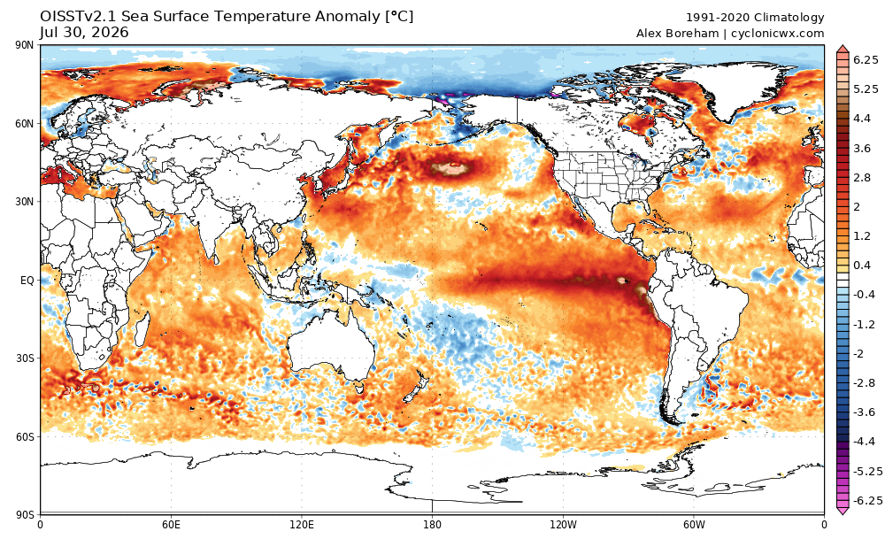
The oceans are on fire globally -

Dewgust 2026: Summer's Last Stand
CoastalWx replied to Prismshine Productions's topic in New England
87 and moist. As it should be. -

2026-2027 Super El Nino
bluewave replied to Stormchaserchuck1's topic in Weather Forecasting and Discussion
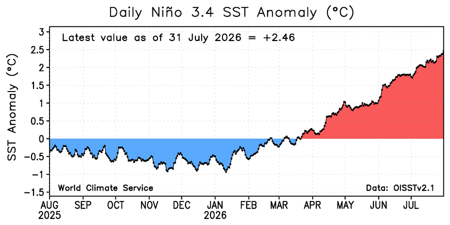
First July 31st ever with a +2.46 Nino 3.4 SST anomaly and a -2.03 PDO.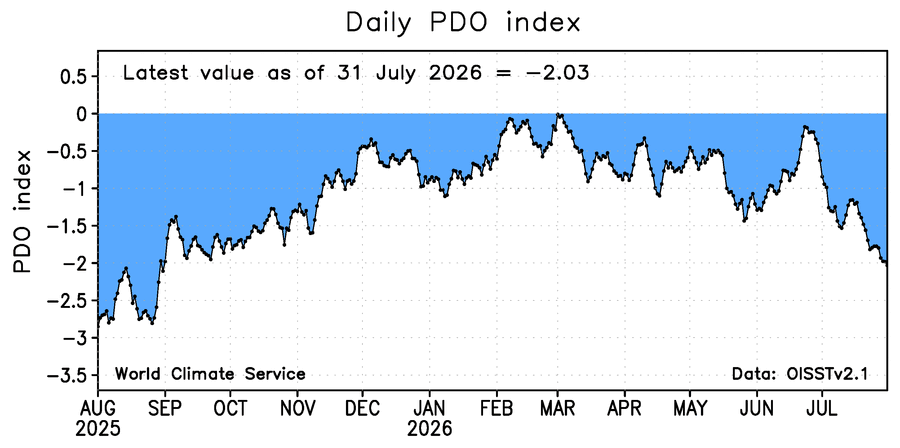
-
Imby/Columbia had 6.89” for July ‘26. Highest since 9.23” in July 2025; but honorable mention goes to May 2026 with 6.29”.
-
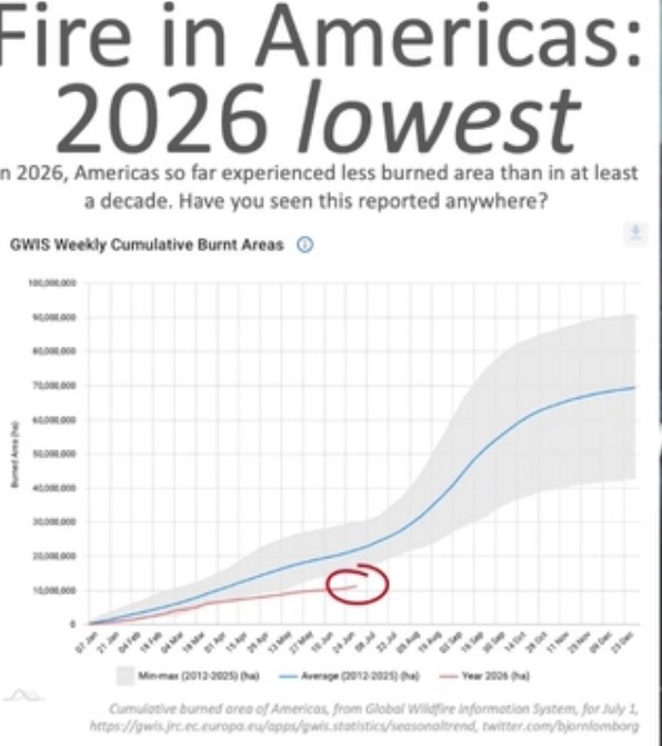
^ looks like it’s through just July 1st?
-
Really impressed with the humidity this summer. Even the NW flow patterns aren't really fending off the dews very much. Biked over at Little Bennett yesterday and it had that classic, mid-Atlantic sticky feel in the air. Trails were actually fairly dry, though...which was a little surprising given the recent rain.
-
Appears next week out West will experience the peak intensity of the summer ridge, then it will start to decline. I will go out on a limb and say we have seen the last of the 95 plus heat here.
-
Opinions about this, which shows lowest cumulative YTD burnt area as of July 1st in Americas since at least 2012?@donsutherland1@WolfStock1
-
Up to 88. If not for clouds would probably see some 90s today
-
My 36-hr rain total is 4.27".
-
Pretty seasonable wx here in town the next few days with highs in the 70's, and a Lake breeze from the E/NE. Only picked up a few hundredths of rain yesterday as it petered out. Next chance looks to be Mon night into Tues morning.
-
 generic sildenafil [url=http://medmennews.com/#]sildenafil 50 mg price[/url] Cheap Sildenafil 100mg
 -
buy Viagra online: Med Men News - over the counter sildenafil
-
I’ll be in Berlin, Md <—> Assateague. Could change or cancel reservation no later than today but decided we’re going. Sunday & Wednesday look “fairly” decent, Monday & Tuesday questionable. But not rain all the time. I’m good with only overcast skies if it doesn’t rain all day at the beach — still getting the UV rays, may feel more comfortable, perhaps less people.
-
Looks like no major heat in the long term. Maybe no more 95°+ days?
- Today
-
Flood Watch up for IWX’s Indiana counties.
-
August 1 1955: A thunderstorm in Becker County dumps a foot of rain at Callaway. For Saturday, August 1, 2026 1954 - Mount Rainier in Washington State was still covered with sixteen inches of snow at the 5500 foot level following a big snow season. (David Ludlum) 1985 - A nearly stationary thunderstorm deluged Cheyenne, WY, with rain and hail. Six inches of rain fell in six hours producing the most damaging flash flood of record for the state. Two to five feet of hail covered the ground following the storm, which claimed twelve lives, and caused 65 million dollars property damage. (Storm Data) 1986 - A powerful thunderstorm produced 100 mph winds and large hail in eastern Kansas and southwestern Missouri causing 71 million dollars damage, and injuring nineteen persons. It was one of the worst thunderstorms of record for Kansas. Crops were mowed to the ground in places and roofs blown off buildings along its path, 150 miles long and 30 miles wide, from near Abilene to southeast of Pittsburg. (The Weather Channel) 1987 - Record heat gripped parts of the Midwest. A dozen cities reported record high temperatures for the date, including Lincoln, NE, with a reading of 105 degrees, Moline, IL, with an afternoon high of 103 degrees, and Burlington, IA, with a reading of 102 degrees. (The National Weather Summary) 1988 - Two dozen cities in the Upper Midwest reported record high temperatures for the date, including La Crosse WI with a reading of 105 degrees. Highs of 103 degrees at Milwaukee, WI, and South Bend, IN, were records for the month of August. (The National Weather Summary) 1989 - Hurricane Chantal made landfall along the Upper Texas coast about sunrise. Chantal deluged parts of Galveston Island and southeastern Texas with 8 to 12 inches of rain. Unofficial totals ranged up to twenty inches. Winds gusted to 82 mph at Galveston, and reached 76 mph in the Houston area. Tides were 5 to 7 feet high. The hurricane claimed two lives, and caused 100 million dollars damage. (The National Weather Summary) Observances: 1 Sat National Sunflower Day 1 Sat International Childfree Day 1 Sat National Minority Donor Awareness Day 1 Sat World Scout Scarf Day 1 Sat National Girlfriend Day 1 Sat Colorado Day 1 Sat World Lung Cancer Day 1 Sat Lammas Day 1 Sat World Breastfeeding Week 1 Sat Homemade Pie Day 1 Sat International Can-It Forward Day 1 Sat National Planner Day 1 Sat National Raspberry Cream Pie Day 1 Sat National Promise to Care Day 1 Sat Play Ball Day 1 Sat Respect For Parents Day 1 Sat Rounds Resounding Day 1 Sat Spider-Man Day 1 Sat Start Up Day Across America 1 Sat Woman Astronomers Day 1 Sat World Wide Web Day
-
most of this upcoming week will feature T-storm potential - flooding potential and high humidity - should be interesting watching the radars and SPC severe outlooks and reports............more of a dent will be put in the drought areas
-
DLH had an avg July temp of 71.1. Tied 4th with 2019. Very warm! Out of 80 unique temps recorded since 1874, midpoint temp is 66.0. PWS near old wx bureau site had 71.8, which would have been 2nd. DLH picked up 2.41" of rain yesterday. 4.69" for the month. That put them above avg by 0.77". Just as a side note, DLH has missing data for the 27th & 28th. But, NWS obs map has data for DLH on those days, so a reporting error there. I've included the data in this analysis. But in contrast, TH coop had a avg temp of 63.2. That tied 45th warmest out of 73 unique temps since 1894. Midpoint temp is 64.2. Much cooler along the shoreline. 2.49" of precip fell short of avg (4.05").
-
Weeks in between wet vacuuming my basement. Ahh the joys of Chicago living
-
 Dolphin is evolving into a Caterpillar 797 tire..
 -
Ber is coming but Brr is not