All Activity
- Past hour
-

2025-2026 ENSO
donsutherland1 replied to 40/70 Benchmark's topic in Weather Forecasting and Discussion
My confidence that we are in the early stages of what will be a regime change to a predominantly positive PNA since the end of the PNA- regime on January 11th has increased. The latest guidance shows most of the days will be positive through at least January 26. The regime change is consistent with historic experience following 25-day or longer PNA- regimes during winter.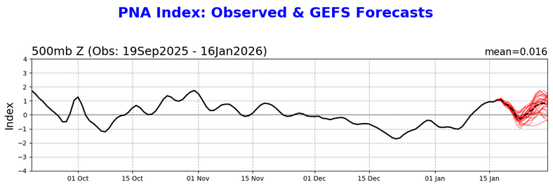
-

Another Coating of Snow Saturday - "It's all we Got"
metagraphica replied to Sey-Mour Snow's topic in New England
Looking forward to my 0.14" of rain. -
Thanks, Brick. Even that’s probably overdone in much of the blue area (1”+) due to marginal temps. But that blue area an hour or so to my west is my tentative target for a Sun drive.
-

First Legit Storm Potential of the Season Upon Us
TauntonBlizzard2013 replied to 40/70 Benchmark's topic in New England
A decade ago, this would be an easy trend in to 8-12” region wide. My guess is this ends up out to sea. We’ve seen this exact pattern play out already like 3 times this year. Threat looks awful at day 4. Subtle trends back the next few cycles, and then the rug pull and it spends the final 48 hours ticking east -
I’m not nearly as knowledgeable as most people here on MJO stuff but the look at the end of the ensembles does not look like a phase 8 or even 7 for that matter to me. It almost looks like it’s moving to something you’d see in 6.
-
Gotta love the 1994 event summary. Frigid air over eastern Canada just continued to push and funnel straight south over snow covered ground. Met up with moisture from the south and snow and ice events were plentiful. Thing I remember most is the frozen solid ruts of snow and ice on the roads for days at a time. With snow, sleet and freezing rain the road crews could not properly clear the roads and everything just froze solid. Was like driving on an obstacle course.
-
Check out the other mesoscale models for tomorrow- it’s not the only one.
-
NAM went from this To this in one run.
-
really ?
-

First Legit Storm Potential of the Season Upon Us
CoastalWx replied to 40/70 Benchmark's topic in New England
You’ll be fine. Should get some tomorrow. -
I'll keep hugging the HRRR and RGEM. Then when nothing happens, I'll rant about what horrible models they are. Chilly Jebwalk this morning, 23F.
-

First Legit Storm Potential of the Season Upon Us
HoarfrostHubb replied to 40/70 Benchmark's topic in New England
I'm ready for that -

First Legit Storm Potential of the Season Upon Us
ORH_wxman replied to 40/70 Benchmark's topic in New England
It was one of the western outliers so I’m not too concerned it ticked east a little at 06z. It would be more concerning if it did it again at 12z. -

First Legit Storm Potential of the Season Upon Us
dendrite replied to 40/70 Benchmark's topic in New England
That H5 look resembles the euro although it’s still a bit flatter. -
The models know lol
-

Winter 2025/26 Banter Thread
TheClimateChanger replied to Chicago Storm's topic in Lakes/Ohio Valley
Views like that, and snow like the above... count me in! -
Was just thinking....those poor fish getting carpet bombed by goose turds. 24k is a little much.
-
Crazy because we just had a country wide blowtorch, and in fact, most of the central and west US have been in a blowtorch since November. After the end of the month, long range looks ugly, but it could be just reverting back to its La Niña bias
-

First Legit Storm Potential of the Season Upon Us
Spanks45 replied to 40/70 Benchmark's topic in New England
The RGEM looked like it started shuffling east at 6z.....Not that I put too much into that model, but it was quite steady for a while until then. -
So it’s moving towards 10 o’clock and we are stuck at 24° with a decent cloud deck that has moved in. WAA can overcome a solid cloud deck, but it’s gonna have to be a decently strong WAA. .
-

E PA/NJ/DE Winter 2025-26 Obs/Discussion
Fields27 replied to LVblizzard's topic in Philadelphia Region
Nam then shifts way east for the Monday coastal. Pretty much no snow for anyone on the east coast. Sent from my SM-S938U using Tapatalk -
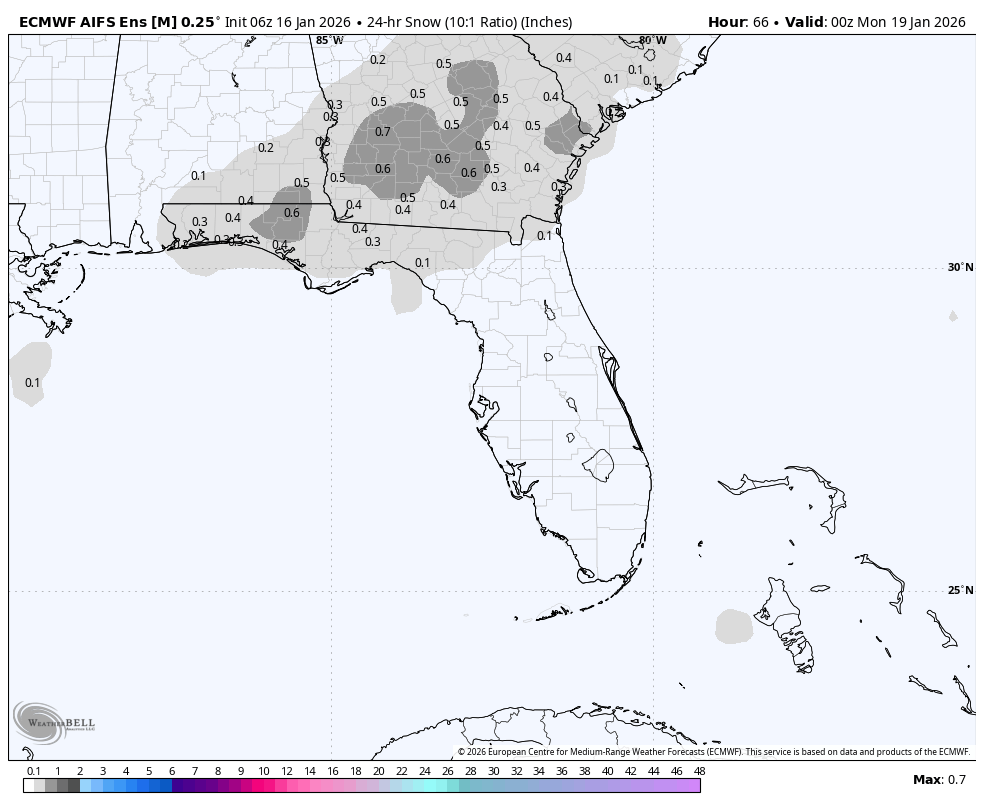
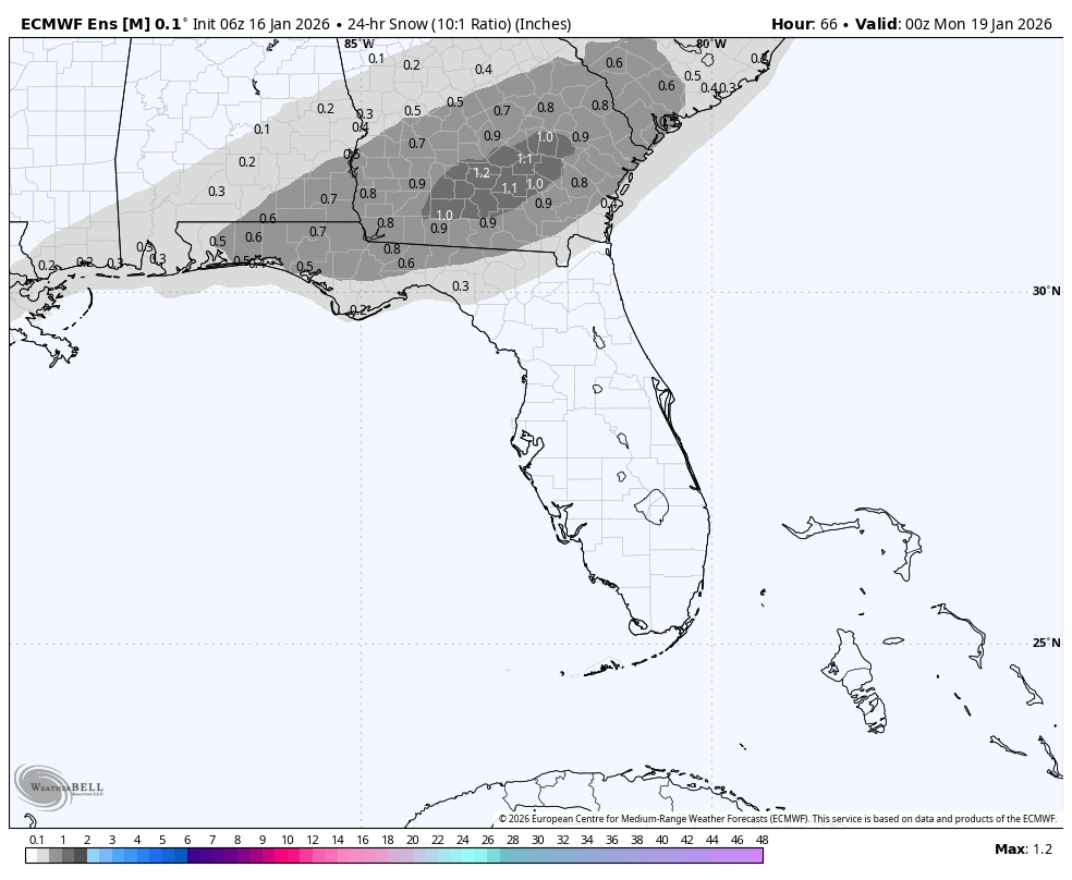
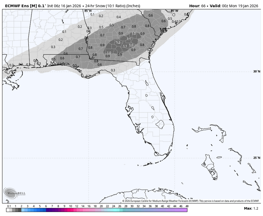
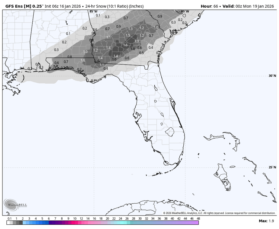
Very rare S GA snow: will it happen? This potential is exciting, but accumulations are probably overdone. I’ll be considering driving to it if it’s within a 1-1.5 hours drive out I-16 assuming the roads are not too affected, which is my guess due to marginal 2m temps. Right here, I’m hoping for a few flurries mixed in with the rain, but there could easily not be any snow mixing in as it doesn’t look quite cold enough right now though I’ll keep monitoring for model changes: 6Z 1/16 EPS: 6Z 1/16 GEFS: 6Z 1/16 Euro AI ens is more realistic imho with lower accums (<1”) but even that would be a rare event:
-

January 2026 regional war/obs/disco thread
jbenedet replied to Baroclinic Zone's topic in New England
That day 9/10 threat I think that’s big dawg potential for mid Atlantic. Our region can be in on it but I really feel like odds are low north of pike. Best focus around interstate 80. Of course early but that’s my feel for best threat in view right now. -
Wow, thanks for all the compliments. You guys are wonderful!
-
January 16 1921: Winds gusting up to 59 mph create a 'sand blizzard' across southwest Minnesota and a snowstorm across the north.