All Activity
- Past hour
-
 It's funny that people think this is something nefarious. The issue is that the weather graphics vendor most stations use (your former employer) have an almost impossible to figure out UI when it comes to building bar graphs and charts. TBH, it's why I don't show them very often. Obviously it shouldn't have been used but we're generally using horribly outdated equipment and graphics systems that are generally awful all around.
 -
Another dying line of storms dropped 0.27" here last night, so I've only received 1.42" this month. The next two weeks look very dry. Some COCORAHS stations in far southern Iowa and northern Missouri are reporting 0.00" this month. Meanwhile, stations from central to northern Iowa and southern Minnesota have received several inches.
-

2026-2027 Super El Nino
GaWx replied to Stormchaserchuck1's topic in Weather Forecasting and Discussion
Dips: below -26 in ‘25, ‘24, ‘22, ‘18, ‘15, ‘12, ‘10, ‘07, ‘05, ‘96, ‘94, ‘84; But none in 1983-1948: why? -
Keep the heat away next week. The last thing the electrical grid needs is us back in the 100s.
-
Today feels like a kind of day where someone’s going to see a lot of rain.
-

2026-2027 Super El Nino
40/70 Benchmark replied to Stormchaserchuck1's topic in Weather Forecasting and Discussion
That looks like the east-based/intense composite forcing, but more expansive both to the east (into S America) AND to the west (towards Dateline). Supports what raindance and I were mentioning RE volatility, albeit a mild national temp in the mean (warmth more anomalous and greater residence than cold) this winter. -
July 9 1932: A tornado touches down near Springfield and moves into St. James, causing 500 thousand dollars in damage. For Thursday, July 9, 2026 1860 - A hot blast of air in the middle of a sweltering summer pushed the mercury up to 115 degrees at Fort Scott and Lawrence, KS. (David Ludlum) 1882 - Ice formed on the streets of Cheyenne, WY, during a rare summer freeze. (David Ludlum) 1936 - The temperature hit an all-time record high of 106 degrees at the Central Park Observatory in New York City, a record which lasted until LaGuardia Airport hit 107 degrees on July 3rd in 1966. (The Weather Channel) 1968 - Columbus, MS received 15.68 inches of rain in 24 hours to establish a record for the state. (The Weather Channel) 1987 - Thunderstorms produced severe weather in Michigan. A tornado near Munising, MI, destroyed part of a commercial dog kennel, and one of the missing dogs was later found unharmed in a tree top half a mile away. (The National Weather Summary) (Storm Data) 1988 - Twenty-three cities in the eastern U.S. reported record high temperatures for the date. Alpena, MI, and Buffalo, NY, suffered through their sixth straight day of record heat. The percentage of total area in the country in the grips of severe to extreme drought reached 43 percent, the fourth highest total of record. The record of 61 percent occurred during the summer of 1934. (The National Weather Summary) 1989 - Morning thunderstorms produced very heavy rain in southern Lower Michigan and northern Indiana. Up to 5.6 inches of rain was reported in Berrien County, MI. Sioux Falls SD reported a record high of 108 degrees. (The National Weather Summary) (Storm Data) Observances: 9 Fri Law Enforcement Appreciation Day 9 Fri Balloon Ascension Day 9 Fri International Choreographers Day 9 Fri National Apricot Day 9 Fri National Austin Day 9 Fri National Carter Day 9 Fri National Faith Day 9 Fri National Law Enforcement Day 9 Fri National WONK Day 9 Fri National Word Nerd Day 9 Fri Play God Day 9 Fri Static Electricity Day
-
 Heat indices in the MRV are modeled around 95° for a couple hours…it’s borderline. The difference I see in the criteria is GYX allows it for any amount of time (1+ day) whereas BOX requires at least 2 straight days of it.
 -
Shallow 5km, so yes, some movement could be felt. A quick rattling of stuff in the house more likely.
-
 That warning is in GYX' CWA. The heat criteria in Maine may be lower than for Massachusetts.
 -
Weather Station
40/70 Benchmark replied to Storm Clouds's topic in Weather Forecasting and Discussion
Tempest sounds like Ambient. I have a separate Stratus rain gage that I use....tipping gage always clogs no matter which station you use. -
euro and gfs miles apart in the extended, gfs not buying torch 2.0
-
 Kind of like on Terminator 2 when the T1000 drove a metal rod through Arnold. You thought he was gone. Then battary backup kicks in, takes the rod out, and goes to fight the T1000.
 -
 Took 24 hours lol.
 -

2026-2027 Super El Nino
snowman19 replied to Stormchaserchuck1's topic in Weather Forecasting and Discussion
We are about to catch up to and surpass 1997 in the eastern ENSO regions: I would echo nearly all of this--the far east Pacific subsurface was warmer in 1997 at the same date, because a huge westerly wind burst occurred late May into early June that year that didn't occur this year until the end of June into July, but that event will more than catch up the signal, because it will engage a 30C isotherm east of the Dateline that was absent in 1997. -
thank you and it is great for chasing the jungles we have here.
-
Maybe the lower dewpoint heat next week will actually bring some high temperatures that don’t underperform for a change.
-
-
Little late to the party but rainfall here reached 2.10" with last event. High temp yesterday of 88°.
-
Hoisting the Sultan Signal: Heavy Rain Event July 5-7
tamarack replied to WxWatcher007's topic in New England
The record broken by the 1984 storm was April 7-8, 1982, the most glorious bust I've enjoyed. Late on April 6, CAR still thought OTS, forecasting 20s, windy, flurries. That blizzard left our black Chevette (a small car, but still . . .) with only a palm-size patch visible. My guesstimate in Fort Kent was 17", while the wind left the snow stake 2" lower than pre-storm, with mounds 5-6 feet tall within 20 feet on either side. March 1984 is now 2nd, behind the 33.1" from an odd stationary storm Dec 25-27, 2005, the bright spot in a down winter. In mid-February a guy from Corpus Cristi, TX called the manager of Aroostook State Park (near PQI) about sledding. The response was that it was very poor, plus a recommendation to head north, to the St. John Valley and points west. -
You always have great photos. I really want to get a drone. Unfortunately it's a want, not a need. So will probably have to wait until Christmas.
-
That area did. I am about 5 air miles from there. They hail and high winds. The storm calmed down a bit by the time it got to my house.
-

Central PA Summer 2026 Discussion/Obs Thread
Jns2183 replied to Voyager's topic in Upstate New York/Pennsylvania
I also bought a good manual rain gauge so that I could start reporting to https://www.cocorahs.org/ I implore everyone here to start that. This area is hurting for people and it would actually make a real difference since there data is ingested for model verification. Sent from my SM-S731U using Tapatalk -
The rocket launch this morning above the patchy fog.
-
(002).thumb.png.6e3d9d46bca5fe41aab7a74871dd8af8.png)
Central PA Summer 2026 Discussion/Obs Thread
ChescoWx replied to Voyager's topic in Upstate New York/Pennsylvania
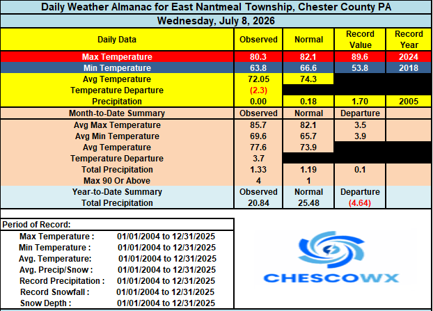
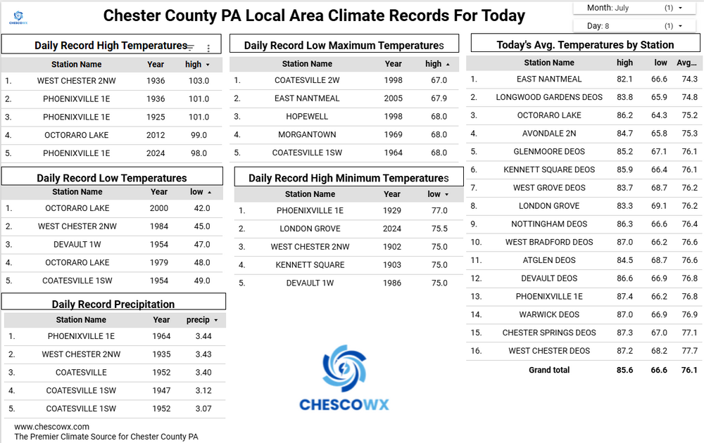
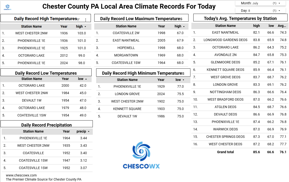
A flood watch is in effect through midnight for the potential of some heavy rain. Some isolated spots could see the rain fall at 1" to 2" per hour. No doubt with our rain deficit let's hope we all see some beneficial rain today! Additional shower chances tomorrow before we start to clear out on Saturday. Today will be our 4th straight day with below normal temperatures this should continue through the weekend before we warm to normal on Tuesday in the mid-80's and above normal with near 90 by Wednesday. It looks like great weather for the All-Star Game in Philly next week.