All Activity
- Past hour
-
Yeah. It seems people that don’t follow the weather always have this misconception that drastic daily changes in weather and or extreme heat or cold never used to happen. It doesn’t help when any media story about the weather basically reinforces that idea.
-

2025-2026 ENSO
PhiEaglesfan712 replied to 40/70 Benchmark's topic in Weather Forecasting and Discussion
April 2007, in addition to being cold, was really wet. I think it was the wettest April on record at PHL. If only we had that wet pattern in February, we could have done some epic snow totals that month. -
unexpected convection and blow off cirrus will keep it in check....almost always does. It'll feel like summer,and the lighting bugs will prosper. Good stuff.
-
Generally speaking from heat-waves in the past with dews that high, the temps seem to under-perform a bit around here. Be interesting to see if that will happen this time around, especially after this deluge.
-
2-3 days of 90s and dews in the 70s here then moderation and hopefully a ring of fire pattern. Of course it’s centered right on the weekend so the beaches will be absolutely packed.
-
We have had weeks with more precipitation than this, but I cannot remember a time where everything has been wet for nearly a week straight. At no point since Friday could I have mowed the lawn or sat on a chair outside without wiping it off. Maybe 2018?
-
Decent day. Sun beating down on yard, you could just feel tge moisture evaporating. Sitting in backyard now watching the huge storms over Sussex county move to my northeast from little ferry.
-
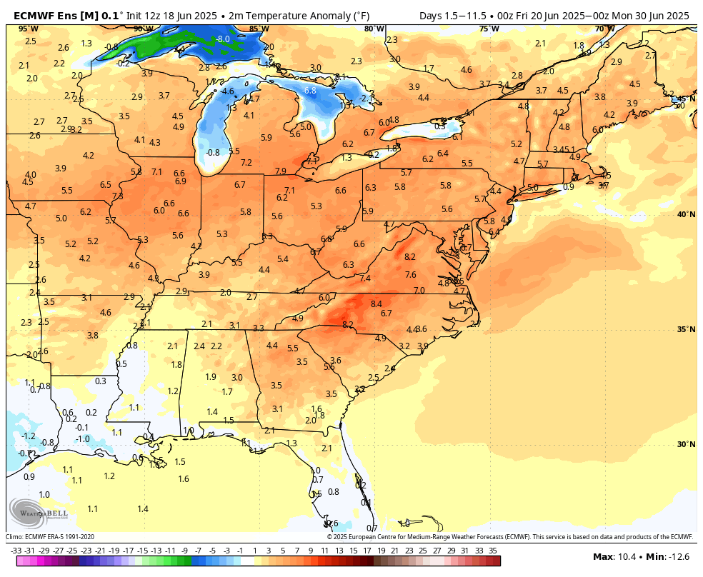
Warmer air began to overspread the region today. This week's warmth will peak tomorrow with temperatures reaching the upper 80s across the region. A few areas could reach or exceed 90°. The arrival of this warmth will mark the start of a sustained period of above normal temperatures. No exceptional heat appears likely through the first three weeks of June. However, that will likely change shortly afterward. Excessive heat is possible starting early next week. Temperatures will likely top out in the lower and middle 90s in the New York City area and upper 90s to lower 100s in the hot spots in New Jersey. There remains some uncertainty about the magnitude of the heat. The ENSO Region 1+2 anomaly was +0.5°C and the Region 3.4 anomaly was 0.0°C for the week centered around June 11. For the past six weeks, the ENSO Region 1+2 anomaly has averaged +0.30°C and the ENSO Region 3.4 anomaly has averaged -0.05°C. Neutral ENSO conditions will likely continue through at least late summer. The SOI was -4.36 yesterday. The preliminary Arctic Oscillation (AO) was +1.248 today. Based on sensitivity analysis applied to the latest guidance, there is an implied 71% probability that New York City will have a warmer than normal June (1991-2020 normal). June will likely finish with a mean temperature near 73.5° (1.5° above normal).
-

2025-2026 ENSO
TheClimateChanger replied to 40/70 Benchmark's topic in Weather Forecasting and Discussion
It was two separate sites. Baraga 1N was 60/20; and Wetmore was 66/20. Even Gaylord in the lower Peninsula was 72/49, so there was a wide disparity from south to north. -
Cell in SW Wayne county starting to have that look to it
-
Tornado warning south of Findlay. Line approaching I-75
-
-
Brawndo has electrolytes
-
WB 12Z EPS 10 day dry and hot period after tomorrow.

-
Already did.
-
1.16" from that cell here. Came down in a hurry
-
2025 ...FLOOD ADVISORY IN EFFECT UNTIL 845 PM EDT THIS EVENING... * WHAT...Minor Flooding caused by excessive rainfall is expected. * WHERE...Portions of northeast New Jersey, including the following county, Passaic and southeast New York, including the following counties, Orange and Rockland. * WHEN...Until 845 PM EDT. * IMPACTS...Minor flooding in low-lying and poor drainage areas. Ponding of water in urban or other areas is occurring or is imminent. * ADDITIONAL DETAILS... - At 652 PM EDT, Doppler radar indicated heavy rain due to thunderstorms. Minor flooding is expected to begin shortly in the advisory area. Up to 0.5 inches of rain have fallen. - Additional rainfall amounts of 1 to 2 inches are expected over the area. This additional rain will result in minor flooding. - Some locations that will experience flooding include... Monroe, West Point, Warwick, Chester, Greenwood Lake, Florida, Harriman, Unionville, Upper Greenwood Lake, Kiryas Joel, Woodbury, Firthcliffe, Cornwall On Hudson, Fort Montgomery, Pine Island, Tuxedo Park, Central Valley and Highland Mills. - http://www.weather.gov/safety/flood
-
Tamaqua Split was in full force today. Storms rolled and rolling along I-80 and south of I-78. Tamaqua...not a drop.
-

2025 Spring/Summer Mountain Thread
Buckethead replied to Maggie Valley Steve's topic in Southeastern States
Just caught a double rainbow up on the AT! Sent from my SM-S908U using Tapatalk -
.25” for me today. A lot more just to the SE.
-
Incredibly fast EWRC
-
Juneau , AK with 40 degree N PAC water and climate year round ripping Tor’s. When do we wave white flag?
-
Unless June 2011 is staring us in the face, I’ve checked out of anything convective related.
- Today
-
Some more cells approaching from eastern Pa and Sussex county, NJ. We’ll see what happens.
-
Impressive.


.thumb.jpg.6a4895b2a43f87359e4e7d04a6fa0d14.jpg)