All Activity
- Past hour
-
 At least we aren't in range yet to get 18Z Nam'ed.
 -
Didnt think you could read it,it was so small,that was IDSS,just find where you are at then right click https://www.weather.gov/forecastpoints?lat=36.1756&lon=-86.7781&clat=36.154&clon=-86.711&zoom=12&basemap=stamenterrain&bbox=[-19719439.353,1706090.691,-1372338.093,10673494.116]&layers=RangeRings|USStates|USCounties|ForecastDot|Domain|#
-
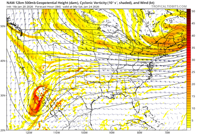
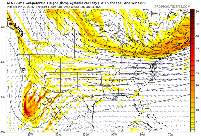
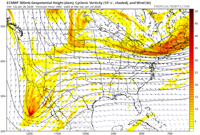
Nam, Gfs and euro. Can see Nam looks more like euro here
-

Central PA Winter 25/26 Discussion and Obs
Mount Joy Snowman replied to MAG5035's topic in Upstate New York/Pennsylvania
I saw that, give us more Eric! Also, enjoy your trip pal. -
He would be a legend in his school.
-
Totals are going to be all over the place. Most if smart will be very conservative.
-
Need a break from analyzing the growing potential of a weekend winter storm? So do I. Here is some long range stuff.... Feb 2-7....looks like we get a break and a WELCOME warmup. We may need it. Here are 30 day maps from the Euro Weeklies mean and control today. The other is the CFSv2 from lunch. There is a good chance that Feb 2-7th is halftime for winter. The Euro Weeklies control has two more substantial cold shots embedded. One is at d20-27. The 500 pattern again looks ripe for February. I have listed Feb7-March7 as the next possible big window. This runs a little bit against overall Nina climatology, but I bet you can find a group of La Nina winters which have a small cluster of very cold Februarys. In fact, this might well be a Nino pattern beginning to flex just a little. Nice EPO, NAO, AO block. Again, this is how you trap cold air under a block and send it southward. Precip during this time frame looks seasonal, and I would doubt this would be a dry time as climatology favors increasingly wet weather as we slowly approach spring. As for spring....man, it looks way out there as of this writing. Now that could change, but there are some signs winter may linger this year well into March. If this pans out, Larry Cosgrove put together a gem of a seasonal forecast. Uncanny. I don't think wx modeling can outrun the human mind - yet!
-
 Nevermind…Jan 22 I assume. Yeah it’s likely undercatch from wind.
 -
Just set a floor, use #’s and percentages, much like the agencies do. Just be sure to dumb down for folks.
-
Either scenario could be an escape path due largely to 500 mb/track changes. Or qpf could drop substantially due to track change and/or moisture content dropping. I think the most likely help would be from sleet replacing a lot of the ZR.
-

Central PA Winter 25/26 Discussion and Obs
paweather replied to MAG5035's topic in Upstate New York/Pennsylvania
Getting a winter storm around SC PA has been more of a challenge in recent years. Hope this is one it can all come together and deliver. -
Hey, what college do you go to and what are you studying! I'm a student at UVA planning to major env sci and politics. Good to have another college kid on here.
-

Possible Record Breaking Cold + Snow Sunday 1/25 - Tuesday 1/27
Brian5671 replied to TriPol's topic in New York City Metro
18Z GFS late last week had a crazy run with 30-50 inches of snow in PA and some nearby places-it was gone on the next run-but yeah the 18Z run (happy hour run) has shown some crazy solutions over the years -
I don't know that ANYBODY should be issuing or disseminating accumulation forecasts at day 4+ I get there is "pressure" to give a best guess...but you can always say - it's too early to tell. Probably a solid "forecast" at this range, however.
-
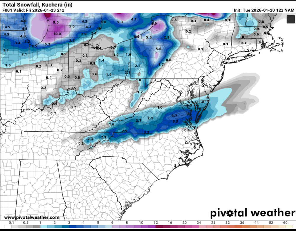
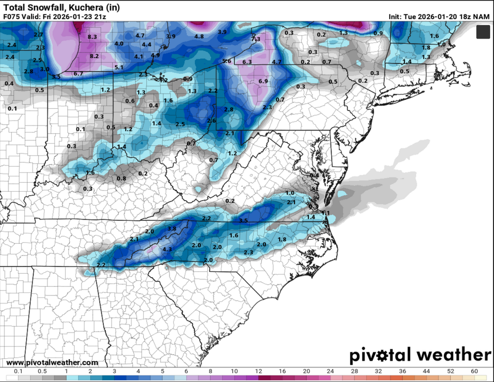
For the Friday "forerunner" system, the 18z NAM moves the snow about 150 miles west-southwest, and increases the totals a bit over 12z. Maybe one should prep for the big one Thursday instead of Friday?
-
Don’t give him the foot’s forecast strategy right outta the gate Randy.
-
Ran*y I’m not sure what Old Ebbits does anymore but maybe a meetup for some sters Friday evening somewhere? I can come pick you up if needed .
-
Not sure it matters, but looks the opposite to me?
-
Hey yall. Stop. Stop this now.
-
RAH still have not updated their discussion this afternoon. I guess those boys are pretty busy...
-
.
-
Yeah. College though, not high school.
-
Look, you’ll never stand out being a follower. My recommendation? 32”-47” with lollies of 50 in favored areas.
-
I've missed many a snowstorm in Puerto Rico. It's beautiful, hope you get to make it there (on Wednesday).
-
Their snow totals dont seem to match up for my area with other forecasts I have seen