All Activity
- Past hour
-
Favored yeah but would t be surprised to see some showers and drizzle on the coast .
-

Saturday 9/6 Strong/Severe storm potential
Torch Tiger replied to Torch Tiger's topic in New England
The event was as a whole, fairly meh. But great to see there were a few lighter-fare tors. -

September 2025 OBS-Discussion centered NYC subforum
steve392 replied to wdrag's topic in New York City Metro
2001/2002 was that bad, jeesh. 02/03 was that epic winter, correct? -

September 2025 OBS-Discussion centered NYC subforum
Stormlover74 replied to wdrag's topic in New York City Metro
<10" of snow. Southern mid Atlantic did well -
It's intensely demoralizing to realize we're likely staring yet another dead ratter winter in the face. I haven't hit climo snowfall in almost a decade.
-
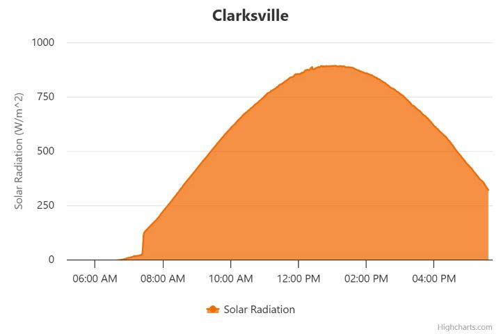
You can tell we're losing sun angle. Not a single mesonet site git 1,000w/m^2 today despite full sun.
-

September 2025 OBS-Discussion centered NYC subforum
Sundog replied to wdrag's topic in New York City Metro
Yea I remember rainshadow, though I never knew his name. I thought you were maybe talking about Tony Riggi and you made a typo, it's like one letter difference lol Antonio Riggi helped me out like 14 years ago with creating long length radar loops of past storms using archived radar data. He's at Weatherbell now. -

2025 Atlantic Hurricane Season
BarryStantonGBP replied to BarryStantonGBP's topic in Tropical Headquarters
oi lad thoughts on the carib tropical wave Stratton is yapping about? - Today
-
correct me if i'm incorrect, but isn't that the currently accepted scientific understanding and consensus ?
-

Saturday 9/6 Strong/Severe storm potential
HoarfrostHubb replied to Torch Tiger's topic in New England
2 separate touchdowns it appears. there goes the streak. -
Congrats Islands
-

Saturday 9/6 Strong/Severe storm potential
Baroclinic Zone replied to Torch Tiger's topic in New England
EF1 confirmed. Paxton/Holden -
RIP Rick Davies, frontman for band Supertramp.
-
Not a cloud for Howard Co area and west to the Alleghenies http://mesonet.umd.edu/Clarksville
-

September 2025 OBS-Discussion centered NYC subforum
donsutherland1 replied to wdrag's topic in New York City Metro
Much of the region saw its chilliest morning so far this season. Low temperatures included: Binghamton: 44° Bridgeport: 50° Caldwell: 49° Danbury: 44° Farmingdale: 55° Hartford: 45° Islip: 58° Montgomery: 43° New Haven: 50° New York City-Central Park: 56° New York City-JFK Airport: 56° New York City-LaGuardia Airport: 60° Newark: 55° Philadelphia: 56° Poughkeepsie: 44° Trenton: 51° White Plains: 49° (earliest season first 40s since 2001) Temperatures will mainly top out in the 70s during the daytime and fall into the 50s at nighttime in New York City through at least Wednesday. Thursday could be briefly warmer with highs in the upper 70s to perhaps lower 80s. A shower or thundershower is possible on Wednesday as warm front moves across the region and Thursday as a cold front pushes through. The ENSO Region 1+2 anomaly was -0.3°C and the Region 3.4 anomaly was -0.4°C for the week centered around August 27. For the past six weeks, the ENSO Region 1+2 anomaly has averaged +0.33°C and the ENSO Region 3.4 anomaly has averaged -0.32°C. La Niña conditions will likely develop during mid- or late-autumn. The SOI was +0.06 today. The preliminary Arctic Oscillation (AO) was +0.073 today. Based on sensitivity analysis applied to the latest guidance, there is an implied near 61% probability that New York City will have a cooler than normal September (1991-2020 normal). September will likely finish with a mean temperature near 68.1° (1.1° below normal). Supplemental Information: The projected mean would be 0.1° above the 1981-2010 normal monthly value. -

Mid to long range discussion- 2025
WinstonSalemArlington replied to wncsnow's topic in Southeastern States
Golden Grahams Days ahead -

September 2025 OBS-Discussion centered NYC subforum
wdrag replied to wdrag's topic in New York City Metro
Thank you... one thing I didnt see but the data may be inconsequential? Are the new sensors reading slightly cooler when side by side with the replaced 20 year old sensors? -
Wow, I had no idea either
-

-
Christ fire him now. That defense wasn't ever going to stop Allen and the Bills at that point. And predictably they instantly were in FG range anyway after the punt. Put it in the hands of your 2 time MVP QB and Henry to get 3 damn yards then run the clock out.
-
Edit: Low officially was 40. Tied daily record low from 1986.
-
Almost a perfect curve today

-

September 2025 OBS-Discussion centered NYC subforum
lee59 replied to wdrag's topic in New York City Metro
Frost advisory for the Catskills -
Yeah, I’ve been reading discussions elsewhere regarding CC’s general effect on tropical seasons: fewer storms but stronger extremes. Well, we’ve had the stronger extremes with a whopping 11 cat 5s just since 2016! Compare that to the prior 11 cat 5s occurring over a 27 year period meaning a near tripling of their frequency. But what’s not yet evident is the drop in the avg # of storms as there have been 14+ every year since 2016 with 168 storms 2016-24 or an avg of a whopping 19 storms/year! Compare that to only an avg of 14 storms the prior 9 years and 15 during the 9 years before that: https://en.m.wikipedia.org/wiki/List_of_Category_5_Atlantic_hurricanes
-

Fall/Winter Banter - Football, Basketball, Snowball?
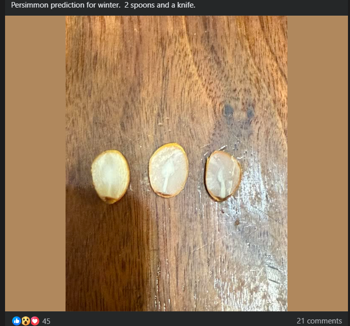
jaxjagman replied to John1122's topic in Tennessee Valley
First time ive heard of this folklore,Its the talk of some people in Lawrence Co.They got 2-spoons and of knife How to make a persimmon seed prediction Split the seed: Carefully cut the seed in half lengthwise with a sharp knife. Observe the shape: Look for one of three symbols within the seed's white inner structure (cotyledon): Fork: Indicates a mild winter. Spoon: Signifies a lot of snow that will require a shovel. Knife: Suggests a cold, harsh winter with biting winds. Find a ripe persimmon: The fruit should be soft and wrinkled when ready. Extract the seeds: Wash the seeds to remove any pulp.