All Activity
- Past hour
-

First Winter Storm to kickoff 2025-26 Winter season
Damage In Tolland replied to Baroclinic Zone's topic in New England
A lot of folks that were expecting snow are going to be upset myself included) These short term trends are brutal. I started sensing it yesterday. I was so looking forward to this too . -
I missed this last month! Thank you!!! Sent from my Pixel 9 Pro XL using Tapatalk
-

First Winter Storm to kickoff 2025-26 Winter season
CoastalWx replied to Baroclinic Zone's topic in New England
Let’s get water to Watatic -

First Winter Storm to kickoff 2025-26 Winter season
SouthCoastMA replied to Baroclinic Zone's topic in New England
looking more and more meh outside of ineedsnow/hubbdave land -
We can't even get rain. Why would it snow lol. At this point I'd be happy with an actual rainy day where it rains all day and we get over an inch. I feel like it's been a couple years since we've had that lol.
-

First Winter Storm to kickoff 2025-26 Winter season
ineedsnow replied to Baroclinic Zone's topic in New England
I feel bad getting excited about this storm -

First Winter Storm to kickoff 2025-26 Winter season
AstronomyEnjoyer replied to Baroclinic Zone's topic in New England
Oh, I'm likin' my spot for this one. -
Us foothill folks heard about the northern stream a lot last year. More of the same. Cold rain or cool/dry. Never any snow for us.
-
it's also worth noting that all the explicit and implicit benefits of the current consumption of energy from fossil fuels are exactly the same as those from the consumption of energy from renewables. Ignoring that both sources of energy on a watt for watt basis provide the same current value to society is illogical. No one is questioning that fossil fuels helped accelerate human social evolution. what is being questioned is what is the comparative future costs and benefits of various energy sources moving forward from the current point in time; historic energy sources are irrelevant to this discussion
-

First Winter Storm to kickoff 2025-26 Winter season
WinterWolf replied to Baroclinic Zone's topic in New England
Let’s see what Goofus says shortly. -
First Winter Storm to kickoff 2025-26 Winter season
CoastalWx replied to Baroclinic Zone's topic in New England
The mesos outside of the Nam are quite mild into SNH. -

First Winter Storm to kickoff 2025-26 Winter season
dryslot replied to Baroclinic Zone's topic in New England
And a few others lol -
@40/70 Benchmark Looks like your musing that the SPV regains strength back to climo/average (no not above normal strength) was a good one after all
-

First Winter Storm to kickoff 2025-26 Winter season
WxWatcher007 replied to Baroclinic Zone's topic in New England
Speak for yourself -

First Winter Storm to kickoff 2025-26 Winter season
Typhoon Tip replied to Baroclinic Zone's topic in New England
Little detail about this NAM run ... it's gotta pretty defined CCB band lagging back into central zones passing through 42 hours out. That was less clearly defined in previous runs. If that's true, areas that disappointingly had gone over to big droplet cold rains with one or two windshield cat paws would likely flash freeze while a couple of exit inches. -

Central PA Fall Discussions and Obs
Superstorm replied to ChescoWx's topic in Upstate New York/Pennsylvania
Agree, 1 to 2 inches before sleet and rain. . -
Its December 1 for crying out loud.
-
December 2025 regional war/obs/disco thread
SouthCoastMA replied to Torch Tiger's topic in New England
Realism. Something trackable by 12/6 is still fairly early down here, aside from the locales getting hit tomorrow (ineedsnow/hubbdave/ray, etc). -
(002).thumb.png.6e3d9d46bca5fe41aab7a74871dd8af8.png)
12/3 Snow/Sleet/Mix Bag of Everything Discussion/OBS
ChescoWx replied to Mikeymac5306's topic in Philadelphia Region
The HRRR tries to sneak the 2" line into NW Chesco and close to ABE....for snow weenies we present the snowiest latest models...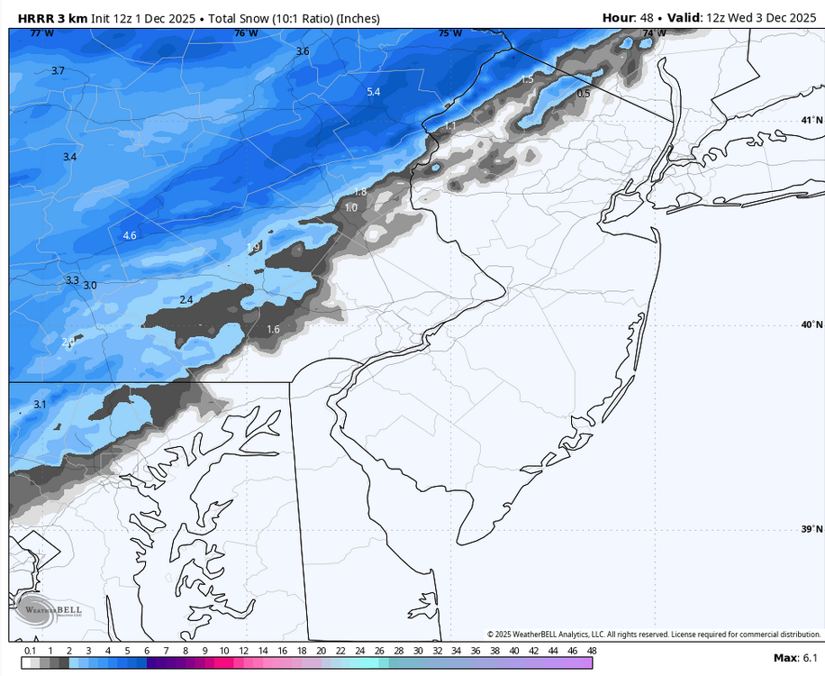
-
The one you were pumping!
-
First Winter Storm to kickoff 2025-26 Winter season
Typhoon Tip replied to Baroclinic Zone's topic in New England
...and I didn't even know any of this was in the works until about 10 minutes ago so .. heh -
12/3 Snow/Sleet/Mix Bag of Everything Discussion/OBS
ChescoWx replied to Mikeymac5306's topic in Philadelphia Region
I suspect even that 1" up at ABE may be a bit overdone if the latest models are onto something...850's a bit toasty -

Central PA Fall Discussions and Obs
Mount Joy Snowman replied to ChescoWx's topic in Upstate New York/Pennsylvania
Morning all, had a great weekend in New Jersey. Met some players' families and tailgated hard. Mum's the word on the coaching search, which is actually quite impressive this day and age. Good times. Low of 32 here and the wife tells me we had our first snow of the season yesterday morning, as some of you have confirmed. I had .03" total qpf from that event so I'm going with .1" of snow/sleet, even if that's a tad generous. On the board! As for tomorrow, looks like things are teetering for those of us down here in Lancaster. I still think we'll squeeze out 2" on the front-end and I'll gladly take it. I've got to get back in the swing of things and start checking some stuff to see how December is shaping up. Feely weirdly optimistic this winter ha. Onward. -

First Winter Storm to kickoff 2025-26 Winter season
weatherwiz replied to Baroclinic Zone's topic in New England
Just northwest of that R/S line is going to rip. That's a nice fronto band that materializes on the NAM. A little concerned though because the DGZ is on the higher side so it will take some heft upward vertical motion to really crank out good growth and rates but that is doable across a narrow swath. Hell, there may also be some thunder/lightning that scrapes the Outer Cape. -
Advisory extended to NW Montgomery & NW Howard counties from 5am to 10am on Tues., 12/2:


