All Activity
- Past hour
-
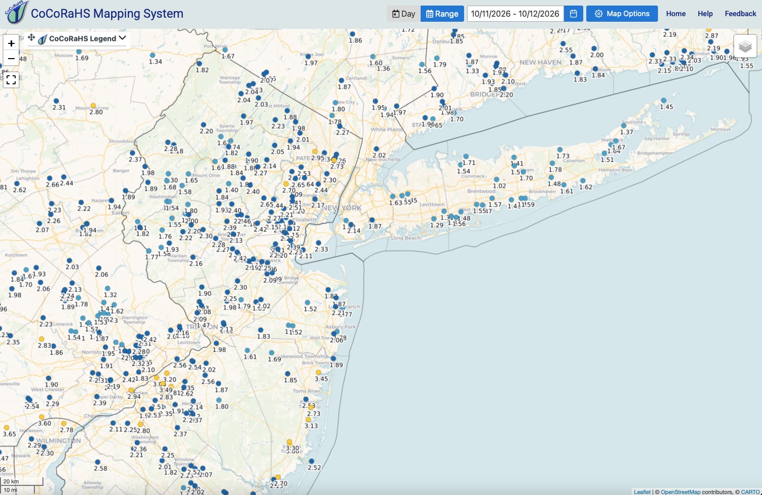
2.48" rain fell from 8:20 am - 9:30 pm imby yesterday in North Haldeon, NJ
-
Hopefully of sign of winter storms this year.
-
I dunno, I have a better feeling about this one. Definitely a different set up than most in recent months. Latest GFS and Euro both actually upped the totals.
-

Central PA Autumn 2026
Itstrainingtime replied to canderson's topic in Upstate New York/Pennsylvania
-

Occasional Thoughts on Climate Change
Typhoon Tip replied to donsutherland1's topic in Climate Change
https://phys.org/news/2026-10-climate-fingerprints-reveal-stronger-evidence.html -
1.9
-
Man, that was rough. To add salt to the wound, the following offseason, the Dolphins passed up on Drew Brees and signed a washed Daunte Culpepper. The butterfly effect of this is that Saban left the Dolphins to join the Alabama Crimson Tide, where he created a dynasty.
-
Strong ridging builds east after the 2 day chilly weather this coming weekend in the 10/19 - 10/26 period. Brunt of the warmth into the GL/Midwest.
-
I'll be honest, the traffic never bothered me. It's like 4-6 days out of 365... foliage is the worst like what we just went through, but you know when its coming and can navigate it. I generally find those things overblown but people lose their minds with social media photos and stuff of peak events. Whatever, its the price you pay for living where everyone wants to visit. For us, it really was the characteristics of the town and where we were changed over time. I don't want to go on an AirBnB rant, I've used them and they serve a great purpose. I'm also not someone who wants to tell someone what they can and can't do with their property. However, we used to have a bit more of a community in the area. Local families lived in our townhome area, we had local young professionals (we lived next to a couple Inntopia developers for up to a decade, F/B Director at Trapps, etc), there were people living nearby, dogs, kids and it felt different. Now, we've seen most of them leave and units turned into straight AirBnB rentals with new folks every weekend. Strangers wandering around, usually respectful, sometimes not, but it's just different. It was like living in the middle of a hotel operation. Cleaning crews rolling in around 11am after folks checkout of neighboring units. The vibe changed drastically over the past decade from one of like community to just living in the middle of vacationers. Units used to be owned by people, now the HOA even just has units with LLCs listed as contacts and it's like, what are we doing? I loved the location, the Rec Path, the river, but as getting older, we stopped going out so being walking distance to like Piecasso became less important. Going to the bars with friends and walking home was fun a 12 years ago, ha. But overall, it was more just having strangers around all the time, people on our porch looking in because they are lost and forgot where they rented for the night, just things that come up when living in the middle of one of the biggest AirBnB battles in the state of Vermont that's raging between the town Selectboard and residents right now.
-
I hope I'm wrong but if it doesn't frost some this weekend, it looks like Halloween or early November for frost for most of NC.
-
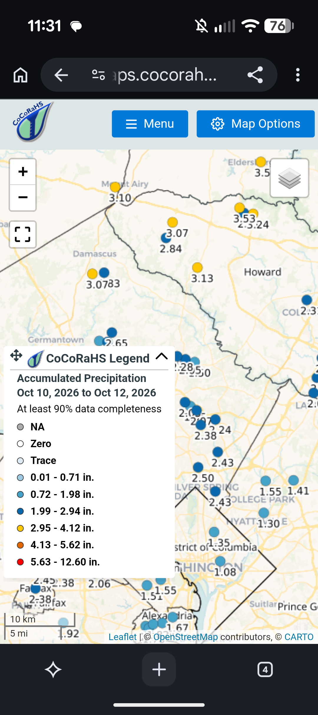
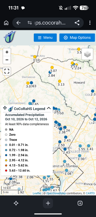
Just on the right side of lucky, nearly 2.5 in here. A few miles to the east, in Northwest Prince George's County, less than 1.5.
-
It’s exactly what it is. It warms AN all next week just like this week
- Today
-

E PA/NJ/DE Autumn 2026 Obs/Discussion
RedSky replied to PhiEaglesfan712's topic in Philadelphia Region
2.00" total -

Mountain West Discussion
mayjawintastawm replied to mayjawintastawm's topic in Central/Western States
Would be nice. The atmosphere always seems to find a way to underachieve lately around here though. QPF Tues-Thurs from NWS for my neighborhood has gone from 0.72" to 0.50" the last 12 hours, would not be surprised if it continues to decrease. -
I hope we don't have a big strong low in the Pacific, which is typical in stronger Niños. Hoping its further west to allow occasional cold shots to come south. The -PDO is interesting if it persists, because typically its in sync with Niños. Also, the climate models are just tools. I know most take them with a grain of salt, but am hoping its colder here than they currently indicate. El niños haven't been too kind to us lately, but niñas have done better imo.
-
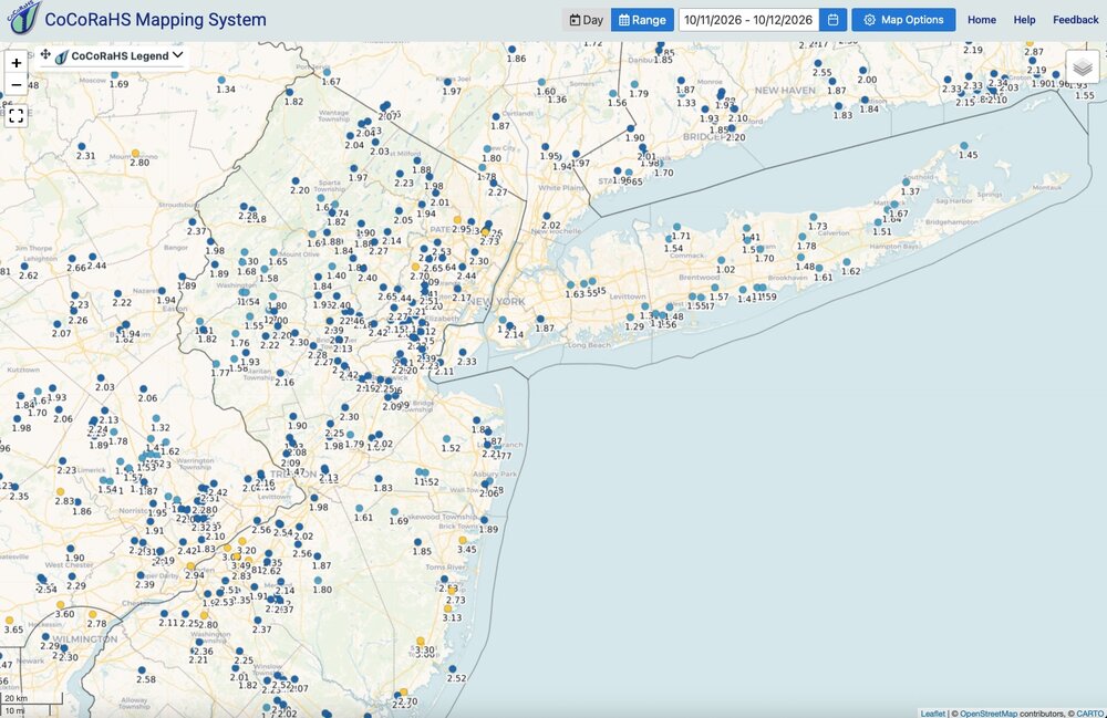
Solid soaking areawide. 1.88" here.
-
My rain gauge topped 4 inches.
-
Central PA Autumn 2026
Itstrainingtime replied to canderson's topic in Upstate New York/Pennsylvania
3.76" here. There's a station about 1 mile NW of me that topped out just over 4". -
 https://cangetrx.shop/# canada drug pharmacy
 -
I stumbled across this image from the East End of Fishers Island during the ‘38 cane and wanted to share it. This area is between the FI Club golf course and the Simmons castle. As you can see, the island was cut in two during the storm. If you could see far enough Napatree Point would be in the background. Just wild stuff. It would take an immense surge to do this.

-
I wouldn’t read too much into this event since it had tropical origins, but either way I’m glad we’re getting more rains and that the heaviest was along the piedmont and mountains. I wouldn’t be surprised to see qpf fields like this throughout the winter. Could be a big year for the ski resorts, and mostly rain for the lowlands outside of (maybe) a well timed storm with cold air.
-

2026 Atlantic Hurricane Season
WxWatcher007 replied to Stormchaserchuck1's topic in Tropical Headquarters
The Gulf signal vanished on GDM, and the subtropics signal is weak at best. This could very well be it for the season. My forecast period is ending 10/20 so it’s almost time to assign a grade. -
Records: Highs: EWR: 88 (1954) NYC: 86 (1954) LGA: 86 (1954) JFK: 83 (1969) Lows: EWR: 35 (1996) NYC: 35 (1876) LGA: 41 (1964) JFK: 38 (1996) Historical: 1836 - A third early season storm produced heavy snow in the northeastern U.S. Bridgewater NY received 18 inches, a foot of snow fell at Madison NY, and for the third time all the mountains of the northeastern U.S. were whitened. (David Ludlum) 1906: Charlotte, NC recorded its' earliest freezing temperature with a morning low of 31°. (Ref. AccWeather Weather History) 1918 - Forest fires ravaged parts of Minnesota from the Duluth area northeastward, claiming the lives of 600 persons. Smoke with a smell of burnt wood spread to Albany NY and Washington D.C. in 24 hours. Smoke was noted at Charleston SC on the 14th, and by the 15th was reported in northeastern Texas. (David Ludlum) (The Weather Channel) 1918: On October 10, 1918, two men working near a railroad siding northwest of Cloquet, Minnesota, saw a passenger train pass by the siding, and soon after, that discovered a fire burning through grass and piles of wood. The fire could not be contained, and by October 12, fires had spread through northern Minnesota. At least 450 lives were lost, and 52,000 people were injured or displaced, 38 communities were destroyed, 250,000 acres were burned. 1942: A tropical storm moved in across eastern North Carolina into central Virginia on October 12, 1942. Torrential rains fell from October 12-16 in Northern Virginia and Maryland. It caused the worst river flood in the history of the Virginia and DC. The hardest hit was the mid portion of the Rappahannock River and the Shenandoah River. On the Rappahannock, damages came to $2.5 million (1942 dollars) and most of that was in Fredericksburg, where the river rose to 41 feet (27 feet above flood stage). On the Shenandoah River, a stage of almost 50 feet was reached at Riverton on the morning of the 16th. Flood stage is 22 feet and it broke the record set by the March 1936 flood by 12 feet! The Potomac at Washington reached 17.6 feet (flood stage is seven feet). Areas of Alexandria and Arlington were seriously flooded. The Anacostia River flooded as well as 6 feet of water was across the boulevard in Bladensburg. Ten to 12 inches of rain fell from Fredericksburg to Warrenton. Seventeen inches were recorded in Front Royal. In Shenandoah National Park, along Skyline Drive, rainfall totals reached 18 to 19 inches. To the south, Nelson County received 16 inches. Another maxima of 12 to 16 inches fell from near Paw Paw, West Virginia south along the Shenandoah Mountains to west of Harrisonburg. About 6 to 8 inches fell over much of central and western Maryland. Highways and bridges were washed away across the region. Over 1,300 people were left homeless in Albemarle, Spotsylvania, Stafford and Warren Counties in Virginia. About 750 people were displaced from homes in Maryland. Hundreds of homes were flooded in Georgetown. Miraculously, only one person died. Transportation was interrupted for three days. Severe damage occurred to crops: peanuts, cotton, sweet potatoes, soybeans, shocked corn and late hay. The heavy rains caused a million bushels of apples to drop before they were picked. 1942 Storm Track - Underground Weather 1962 - The "Columbus Day Big Blow" occurred in the Pacific Northwest. It was probably the most damaging windstorm of record west of the Cascade Mountains. Winds reached hurricane force, with gusts above 100 mph. More than 3.5 billion board feet of timber were blown down, and communications were severely disrupted due to downed power lines. The storm claimed 48 lives, and caused 210 million dollars damage. (David Ludlum) 1950: Charlotte, NC recorded their latest 90° reading ever. (Ref. Wilson Weather History) 1954: Boston, Massachusetts had a maximum temperature of 90 °F the highest temperature for October. They also had 90 °F on October 7th 1963. (Ref. NOAA Boston Weather Events) 1962: The Columbus Day Storm of 1962 was a Pacific Northwest windstorm that struck the West Coast of Canada and the Pacific Northwest Coast of the United States. It is considered the benchmark of extratropical wind storms. The storm ranks among the most intense to strike the region since at least 1948, likely since the January 9, 1880 "Great Gale" and snowstorm. Click HERE for more information from the University of Washington. 1979: The lowest barometric pressure ever recorded occurs in the center of Typhoon Tip on this day. A fly reconnaissance mission recorded the low pressure of 870 hPa or 25.69 inHg. Typhoon Tip was the most extensive tropical cyclone on record with a wind diameter of 1380 miles at its peak. 1981: Hurricane Norma crossed from the Pacific over Mexico and into Southwestern Texas. 25.00 inches of rain fell in the area around Gainesville and Bridgeport, TX. The elephant from the Gainesville Zoo reportedly survived the massive flooding by holding its trunk above the water. (Ref. Wilson Weather History) 1987 - Floyd, the only hurricane to make landfall the entire season, moved across the Florida Keys. Floyd produced wind gusts to 59 mph at Duck Key, and up to nine inches of rain in southern Florida. Sixteen cities in the Ohio Valley and the Middle Mississippi Valley reported record low temperatures for the date. Record lows included 27 degrees at Paducah KY, and 24 degrees at Rockford IL and Springfield IL. (The National Weather Summary) (Storm Data) 1988 - Twenty cities in the Upper Midwest reported record low temperatures for the date, including International Falls MN with a reading of 17 degrees. The town of Embarass MN reported a morning low of 8 degrees. Snow showers in the northeastern U.S. produced five inches at Corry PA. (The National Weather Summary) (Storm Data) 1989 - Temperatures again warmed into the 80s in the Central Plains Region and the Middle Mississippi Valley, with 90s in the south central U.S. Six cities reported record high temperatures for the date, including Fort Smith AR with a reading of 92 degrees. Strong winds along a cold front crossing the Great Lakes Region and the Ohio Valley gusted to 61 mph at Johnstown PA. (The National Weather Summary) 2005: On this date through the 14th, on its way to setting a local record for the month, Central Park in New York City received 8.5 inches of rain over the 3-day period. 16.73 inches fell during October to eclipse a 102-year record. (Ref. Wilson Weather History) 2006: With 0.3 inches of snow falling at O'Hare International Airport, giving Chicago its earliest measurable snowfall. The previous earliest date was 10/18/1972 and in 1989.Snow Trivia for Chicago - NWS (Ref. WxDoctor) 2008: Montana, Wyoming, and Idaho from the 10th to the 12th: A significant winter storm brings heavy snowfall to areas of Montana, Wyoming, and Idaho over three days. The city of Red Lodge, Montana records its highest 24-hour snowfall total with 42 inches of snow. Glasgow, Montana also sets a new October 12th record when 12.8 inches of snow falls. (Ref. WxDoctor)
-
64 / 55 clearing out and drying out while warming up the next 72 hours. Very warm peaking with 80s in the warmest spots on Wed before we slide into a two day chill this coming weekend 10/17-10/18 before that a rainy Friday, then ridging pushes east by the 19th and overall warmer beyond there.
-
Might be a little early for big LES, but first flakes seem increasingly likely up here this weekend.