All Activity
- Past hour
-

Arctic Hounds Unleashed: Long Duration Late January Cold Snap
dendrite replied to WxWatcher007's topic in New England
TOL +6 IJD -10 BOS +12 OWD -15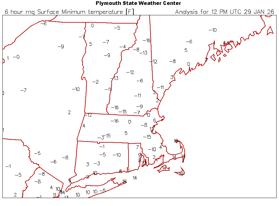
-

The “I bring the mojo” Jan 30-Feb 1 potential winter storm
olafminesaw replied to lilj4425's topic in Southeastern States
I am guessing most of those Eastern solutions are showing an elongated low with deeper pressure on the East side. The GFS OP has this feature, but the primary low on the West side
-

1-30/2-1-26 Arctic Blast, ULL Snow Event
tnweathernut replied to John1122's topic in Tennessee Valley
The truth is probably somewhere in the middle of these QPF amounts on the euro. One thing I mentioned to Carvers yesterday…….. how many times out of 10 things trend (and verify) east and south of modeling inside of 72 hours. My guess would be 1. Doesn’t mean Knoxville area cant work its way out of a snow, but it’s not like it’s a bad thing being on the north and west edge of guidance 36-48 hours out. -
It just increased our snow just a little from 4” @ 10/1 to 80” at 10/1 [emoji23][emoji23][emoji23] .
-

Richmond Metro/Hampton Roads Area Discussion
eaglesin2011 replied to RIC Airport's topic in Mid Atlantic
Again, we don’t want it to move that much more north than it already is.. Dry air would kill us even more .. 3-7 is perfect for me.. I actually would like to be able to get out of my neighborhood in the next week lol -

The “I bring the mojo” Jan 30-Feb 1 potential winter storm
PackGrad05 replied to lilj4425's topic in Southeastern States
I'll gladly take a central NC screw zone of 2-3 inches. Still more snow than 95% of the systems we get. WRAL first call going with 3-6 inches for central NC. -

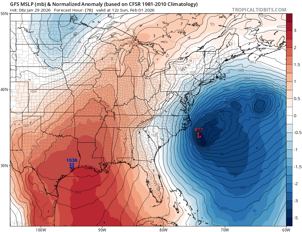
Possible coastal storm centered on Feb 1 2026.
40/70 Benchmark replied to Typhoon Tip's topic in New England
I mean, I could work with this verbatim, but can't afford any more regression today. -
What’s the GFS Graphcast? .
-

Richmond Metro/Hampton Roads Area Discussion
RVASnowLover replied to RIC Airport's topic in Mid Atlantic
https://forecast.weather.gov/product.php?site=AKQ&issuedby=AKQ&product=AFD&format=CI&version=1&glossary=1&highlight=off Morning reading material. -
13°
-
It’s dragging the baroclinic zone too far east and ruining any setup for our storm to dominate and come up the coast. It strings the whole thing out and it drunkenly stumbles out to sea. It’s like seeing a 6’3” 230 pound guy who’s intimidating at first until you realize he’s drunk as a skunk and he stumbles face first into a pole. Awesome potential, terrible verification. The last few winters it’s always something that ruins these setups.
-
-
.thumb.png.4150b06c63a21f61052e47a612bf1818.png)
Arctic Hounds Unleashed: Long Duration Late January Cold Snap
HIPPYVALLEY replied to WxWatcher007's topic in New England
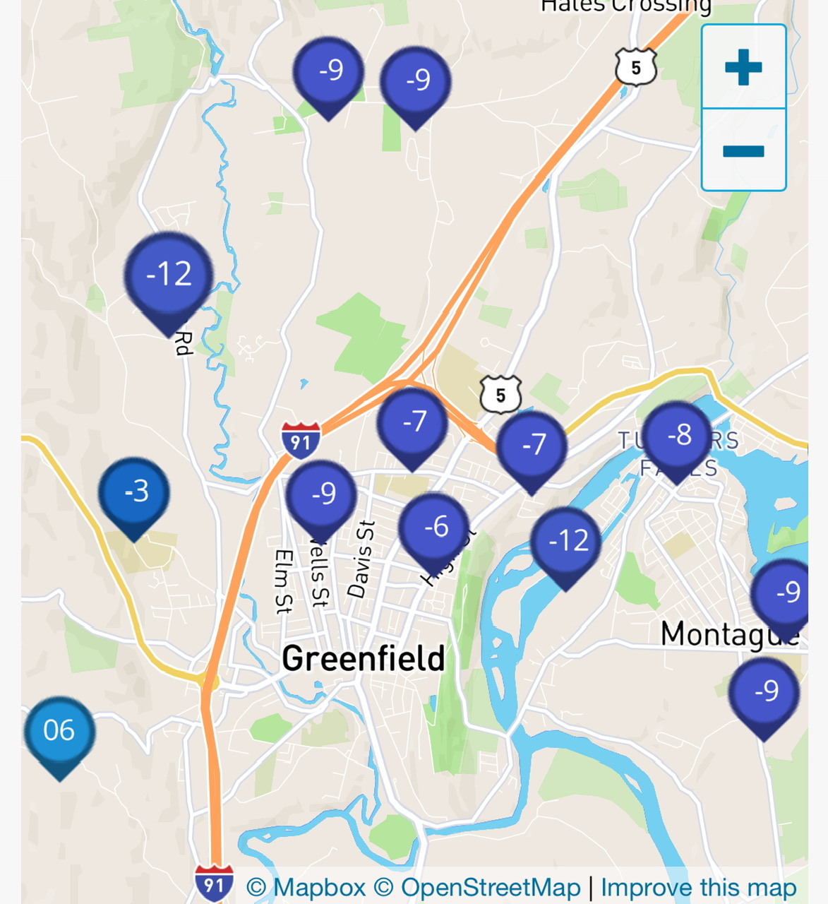
-9° in my yard.
-
3° for a low
-

Possible coastal storm centered on Feb 1 2026.
CoastalWx replied to Typhoon Tip's topic in New England
Winter sucks again -

2025-2026 Fall/Winter Mountain Thread
franklin NCwx replied to Buckethead's topic in Southeastern States
Can you loop the 5h map for us? Thanks ! -

2025-2026 Fall/Winter Mountain Thread
Buckethead replied to Buckethead's topic in Southeastern States
5 with diamond dust and clear skies in Wolf this morning. Sent from my Pixel 10 Pro using Tapatalk -

2025-2026 Fall/Winter Mountain Thread
Sw NC weather replied to Buckethead's topic in Southeastern States
Here’s the EPS.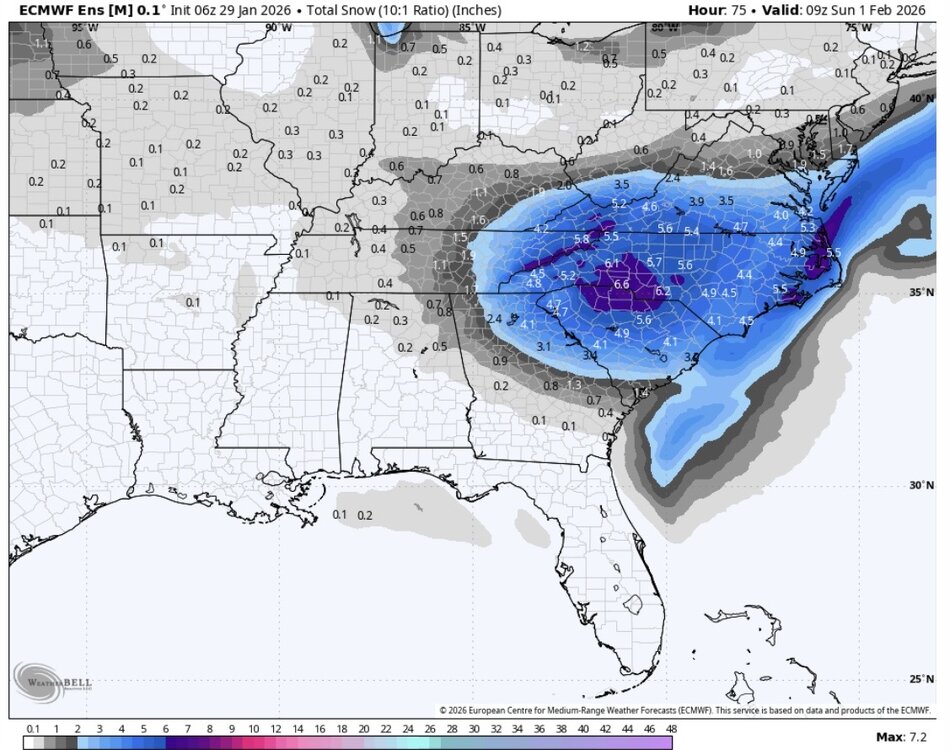
-
Also, we're looking at temps in the low 20s, or even lower during the heaviest of the precip per the 6Z EURO. As time progresses and cold advection intensifies and deepens, profiles will become increasingly supportive of snow:liquid ratios of 15-20:1 during the day Saturday.
-
The “I bring the mojo” Jan 30-Feb 1 potential winter storm
franklin NCwx replied to lilj4425's topic in Southeastern States
Getting caught between the forcing of the upper low transferring to the coastal -

Possible coastal storm centered on Feb 1 2026.
WinterWolf replied to Typhoon Tip's topic in New England
Everybody used to laugh at me when I said the off hour runs were BS…now you see it’s true. They suck. Also as I thought back on Tuesday, that an OTS idea was the bigger worry. Cape cod could see a decent snow…the rest of us are out of it. -

Possible coastal storm centered on Feb 1 2026.
JKEisMan replied to Typhoon Tip's topic in New England
I know this is pulling at straws, but the 9z SREFS looking more up and in - maybe leading the charge to some better solutions lol? -
The “I bring the mojo” Jan 30-Feb 1 potential winter storm
franklin NCwx replied to lilj4425's topic in Southeastern States
Those will most likely "tick up" for the western areas. Our snow comes from the upper low as it swings south and goes negative. Eastern areas need the surface low to develop quicker for their higher totals -
Looking at all the information this morning I think all of wnc with the snowfall rates will see 7-10 inches of snow with very low visibility.
-

The “I bring the mojo” Jan 30-Feb 1 potential winter storm
NorthHillsWx replied to lilj4425's topic in Southeastern States
I hate to say it but we’re trending to getting stuck between the ULL snow and coastal. Not good.