All Activity
- Past hour
-
It came slightly north
-
So much melting
-

Outta gas and Outta Time: Early March Winter Storm finale
Weather Will replied to Ji's topic in Mid Atlantic
WB 12Z Can. Para snows for 24 hours. Fantastic run!
-

E PA/NJ/DE Winter 2025-26 Obs/Discussion
Ralph Wiggum replied to LVblizzard's topic in Philadelphia Region
Euro is exactly where we want ... weak and a little south with the bullseye. -
-

Clipper Fires In Wednesday Feb 25 Disco/ Obs
Brian5671 replied to Damage In Tolland's topic in New England
Yet for the blizzard they came in with 20 which seems high-I was 15-16 here -
The euro has that 1040 high pretty far south and then it retreats so we're able to get some snow in here. I guess that will need to be monitored to determine if this mostly stays south or not
-

Outta gas and Outta Time: Early March Winter Storm finale
anotherman replied to Ji's topic in Mid Atlantic
2018 -

Clipper Fires In Wednesday Feb 25 Disco/ Obs
The 4 Seasons replied to Damage In Tolland's topic in New England
Doesnt surprise me. There was an event earlier in Jan where we had around an inch in the morning right down to the shore and BDR reported T. -
I find that difficult to believe given the visibility over those 3 hours. 18z 1/4sm 19z 1/4sm 20z 1 1/4sm 21z 2sm But it is what it is.
-
Check out the consistency from the Euro AI
-
Outta gas and Outta Time: Early March Winter Storm finale
Grothar of Herndon replied to Ji's topic in Mid Atlantic
-
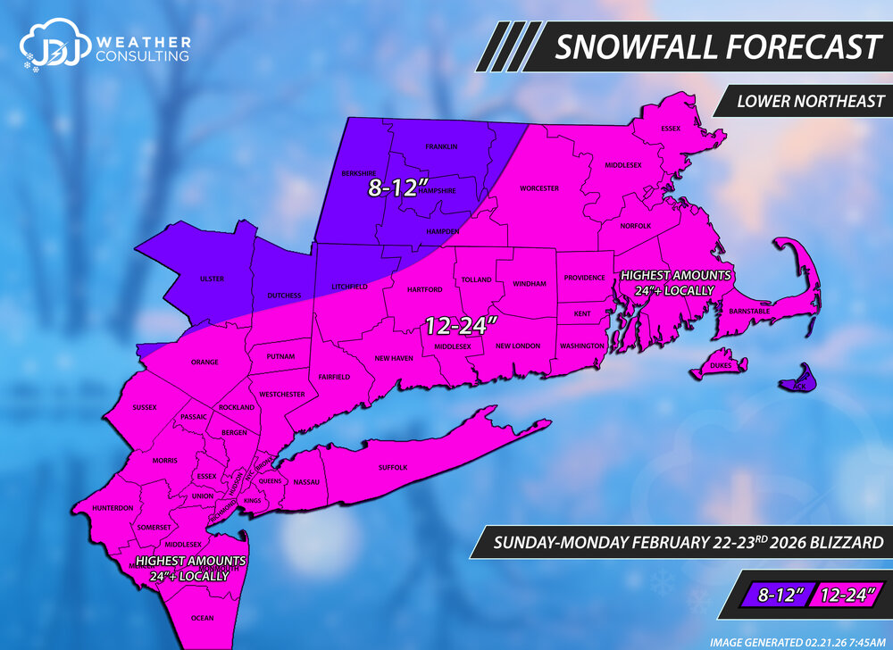
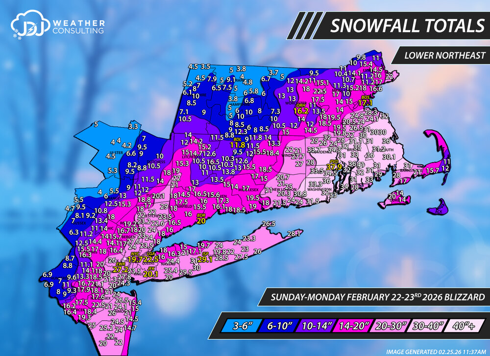
Snowfall totals map for this historic February 22-23, 2026 Blizzard. As always thanks for everyone who sent me reports. Data is from here, cocorahs, COOP and official sites. This L Northeast is all i have done so far after about 16 hours it was a massive undertaking. I tried to include all reports but some don't fit and had to be excluded. The site will be updated soon but these maps are not up yet. This will be the 2nd historic storm of the season and ill have everything including a full radar animation up on the site in the coming days. There is some incomplete data on the PNS and NWS snowfall maps so beware. BOX is only using 1-day cocorahs totals for some reason and not including both days, so a ton of the reports are very low that say "cocorahs" next to them. OKX did the same thing but instead of only including the 23rd they mostly just used the 22nd. On a technical note there is exactly 398 reports on here from well over 1,000 sifted through, probably closer to 2k. This was only the 4th time ever including a 40"+ snowfall contour for all the events i've done. Gotta say this is one the coolest looking snowfall maps ive ever produced. I mentioned earlier the forecast for CT was very good to great. For the overall region it was probably a C/C+? Too low for SE MA/NJ even though i put 24"+ in text, that is not sufficient and it needed a whole new range of 24-36+. Too high for NW MA and Catskills. Our final call was the same as the first but i had a 2nd and final update ready to go where i had SE MA/NJ in a 24-36" range but never posted/released it. I figured the first call was good and didn't want to change the map if i didnt have to but in retrospect im kicking myself a bit for not doing so. Oh well. The Tri-State only map is not done yet but will be coming soon. If there is anything missing or needs to be adjusted let me know. With these big storms, this probably wont be the true final....with an error or two or additional/changed reports needed. First and Final Call
-
Outta gas and Outta Time: Early March Winter Storm finale
Weather Will replied to Ji's topic in Mid Atlantic
WB 12Z EURO

-
Clipper Fires In Wednesday Feb 25 Disco/ Obs
Brian5671 replied to Damage In Tolland's topic in New England
.3 at BDR? LOL ...Fairfield County... 4 NNW New Fairfield 3.0 in 0820 AM 02/25 Trained Spotter 3 E Easton 2.8 in 0943 AM 02/25 Public 3 WSW Shelton 2.5 in 0856 AM 02/25 Trained Spotter 2 ENE New Canaan 2.4 in 1137 AM 02/25 Trained Spotter 1 SE Norwalk 2.4 in 0930 AM 02/25 Trained Spotter 4 SSE Easton 2.3 in 0905 AM 02/25 Public Old Greenwich 2.2 in 0849 AM 02/25 Trained Spotter 3 NNE Old Greenwich 2.2 in 0900 AM 02/25 CO-OP Observer Norwalk 1.6 in 0745 AM 02/25 COCORAHS Ridgefield 2.4 NNE 1.2 in 0700 AM 02/25 COCORAHS Bridgeport Airport 0.3 in 0700 AM 02/25 Official NWS Obs -

Outta gas and Outta Time: Early March Winter Storm finale
Paleocene replied to Ji's topic in Mid Atlantic
-
got to feel bad for the people selling that house next door
-
Outta gas and Outta Time: Early March Winter Storm finale
Weather Will replied to Ji's topic in Mid Atlantic
WB is slow as Moses....not done yet either. -
ensembles for now yes?
-
 DCA _ NYC _ BOS _ ORD _ ATL _ IAH _ DEN _ PHX 0.0 -1.0 -1.5 0.0 +2.0 +3.0 +2.5 +3.0 SEA +2.0
 -

Outta gas and Outta Time: Early March Winter Storm finale
stormtracker replied to Ji's topic in Mid Atlantic
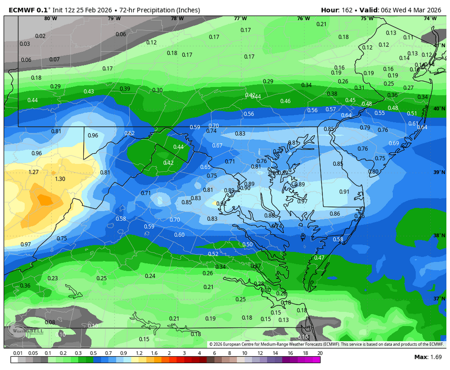
Yall are tired as hell. Nobody posting the Euro stuff? Wake up!! -
2 2-footers in less than a month can really bum a guy out. Think of all those missed opportunities, everything left on the table! Oh my...
-

"Don’t do it" 2026 Blizzard obs, updates and pictures.
ScituateWX replied to Ginx snewx's topic in New England
I’m finally settled after a long stretch of plowing snow. I would have to say in regard to snow intensity over a period of time that was probably the worst I have seen in my lifetime (just turned 40). At the shore in Scituate seems as though the coastal flooding was not as bad as it could have been. The wind direction and timing of tides seemed to work for the better. While there were large breakers and flooding not nearly as bad as the Boxing Day storm or other recent events. -

2/24 - 2/25 Clipper Obs (1 - 2" for many on forum)
CPcantmeasuresnow replied to Northof78's topic in New York City Metro
Central Park was close in 2020/21 with 38.6 inches. I think one if not both of the airports in New York City may have been over 40 inches that winter, someone can check me on that. Don't have the data available now. -
The AI has suddenly gotten a bit shaky the last few weeks. I'm to the point I am blending the GFS with the CMC/Op Euro because its been wildly flopping around with systems since about the start of the month.