All Activity
- Past hour
-
HIghs: Max for the month (so far) TEB: 54 New Brnswck: 53 EWR: 51 LGA: 51 TTN: 51 JFK: 50 ISP: 50 NYC: 49
-
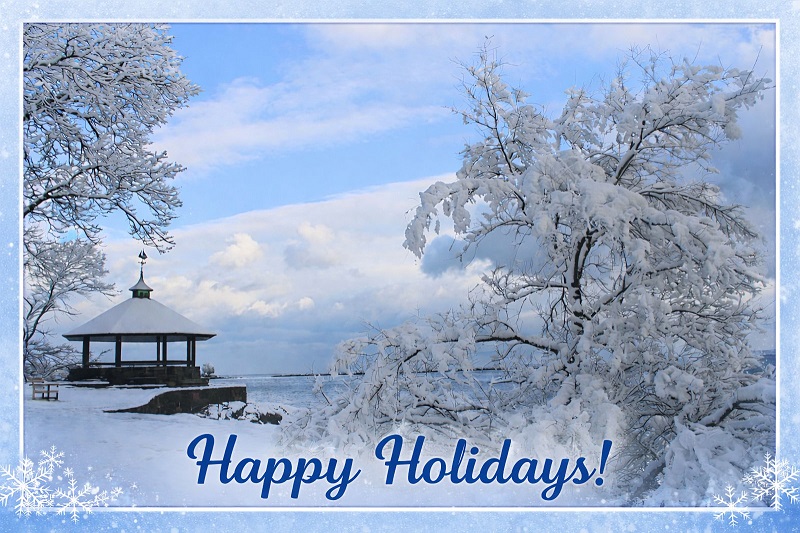
Negativity about this winter seems to be rising. There seems to be a growing focus on the time snow does not fall. I choose to focus on the positive. I savor every snowfall, even the small ones. Sunday's snowfall provided some scenes that can be used for some of the custom Holiday e-cards will share with colleagues at work. One example:
-
horrid decision making. that makes all too much sense.
-

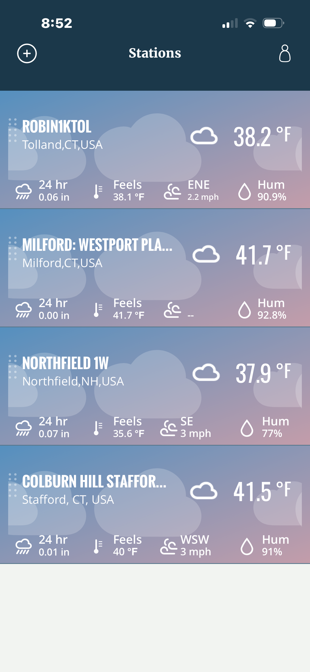
December 2025 regional war/obs/disco thread
WinterWolf replied to Torch Tiger's topic in New England
His scale…”flying no reindeer” what does that mean? Lol. -

December 2025 regional war/obs/disco thread
Damage In Tolland replied to Torch Tiger's topic in New England
Here’s a good sign . Dendy is not CAD. He’s been rising . It’s coming
-
You seem to be obsessed with.
-
December 2025 regional war/obs/disco thread
Damage In Tolland replied to Torch Tiger's topic in New England
The Drake ! https://x.com/danbury_wx/status/2001826392569450513?s=46&t=dhcbvkjmRcyBVQtDxJ3lRg -
Ok, I see your point, ha. I was thinking "big" in terms of QPF/snowfall totals, as opposed to big in terms of publicity or large scale synoptic events. That mid-November one was a solid 7-15" event, even in the valleys around the mountains, while 15-25" at elevation of 1-2" QPF. That was the type I was thinking of... but absolutely nothing of the widespread region wide news worthy storms. I get your point there. I guess what's more eye-opening is the local area wide like 7-12" of QPF since November 1 to now... while maintaining solidly below normal temperatures, if not very below normal temperatures (like -10F so far in December). To have 55-60" of snow depth contain 13" of water is pretty wild to me... because that pack started right around November 1st. So in roughly 6 weeks, that 3,000ft elevation AVERAGED just over 2" of QPF per week, most of it in the form of snow. That's damn impressive, but I guess that's also how you get to record numbers. I do wish we were able to sample individual event SWE/QPF in the higher elevations, as sometimes I do think I conceptually under-estimate just how much precip falls up there in these type of upslope patterns. Many of the November snows that left nearly 70" (measured in a controlled, single spot) on Mount Mansfield during the month felt like they were all there in terms of SWE. That wasn't upslope fluff. Sure there were some endings of fluff and some mixed in, but there were some real healthy dense snowfalls of rimed flakes, graupel, ect even at colder temperatures. I often look at the Alta Collins plot as my gold standard, and often note that for all the hype Utah gets for fluffy snow, they get their share of orographic QPF dumps where its like 12" on 1.50" water. Or even 24" snow on like 3.00" water. I think the local mountains had their share of that type of snow in November, which really boosted base depths and led to that amazing skiing... the type of cold but dense (rimed and graupel) driven snow that can sustain significant skier traffic and hold up fine. Overall, turning a new page after tomorrow as it'll be the first time in like 3 weeks the mountains have sniffed above freezing temperatures and rain. There was one brief rain event around Thanksgiving, that was then covered up almost immediately with more cold, but dense, upslope... and with that brief thaw, the mountains are running like a solid month, or more, of being on a snow and cold heater. Definitely a legendary start and one of yore.
-

E PA/NJ/DE Winter 2025-26 Obs/Discussion
Birds~69 replied to LVblizzard's topic in Philadelphia Region
The past two years have been the most windiest period in my lifetime. Seems like at one point every day there's wind gust or an extended all day period.... -

Saturday night/Sunday 12/13-12/14 Jawn
Ralph Wiggum replied to Ralph Wiggum's topic in Philadelphia Region
This seems pretty spot-on. Credit Paul( @ChescoWx) for this ripped from his FB.
-
All the extended products have been indicating a transition to a -EPO going forward into mid Jan, with a southward displaced TPV. We have seen this look pretty often in recent winters and it brings the cold, then all we need is some luck with a wave riding the thermal boundary. This pattern has produced several moderate snowstorms in our region. I'll take it.
-
E PA/NJ/DE Winter 2025-26 Obs/Discussion
Birds~69 replied to LVblizzard's topic in Philadelphia Region
Big fan of flash freezing with a coating of snow on top. Makes things very difficult to drive and walk, big fan! -
Not a flake here.
-
It shows the NE MD snowhole so this one might be on to something and actually verify. I'd hit it.
-

Winter 2025/26 Banter Thread
HillsdaleMIWeather replied to Chicago Storm's topic in Lakes/Ohio Valley
Oh my god the warning text only calls for an inch of snow, that's embarrassing. If it's for the blowing snow and flash freeze they should've just done a WWA. -
December 2025 regional war/obs/disco thread
WinterWolf replied to Torch Tiger's topic in New England
Off hour runs of late look good…on hour runs go the opposite way. Weird. -
December 2025 regional war/obs/disco thread
WinterWolf replied to Torch Tiger's topic in New England
Ya, see those didn’t do that much here, no power loss. The 12/23/22 that was the warm rain(blizzard in Buffalo), then temps crashed. But again, no power loss. But I get it…out east it was different. -
It’s not, but that’s fine…I’ll move on
-

E PA/NJ/DE Winter 2025-26 Obs/Discussion
Albedoman replied to LVblizzard's topic in Philadelphia Region
I seen so much wind this year== whats another day. I am waiting for the flash freeze from a dusting of snow to appear by tomorrow evening. -
Because, If you start letting things slide everything goes to hill.
-

December 2025 regional war/obs/disco thread
Patrick-02540 replied to Torch Tiger's topic in New England
The only time winds materialized for me, as forecast or greater, was on 12/23/2022- two weeks before my house generator was installed. Lost 3 solid trees, roof shingles/flashing (roof needed to be replaced anyway). Also stupidly left a chair on the back deck which took out 12 spindles on my railing. Power out for three days (right up through Christmas Day), as temperatures had crashed into the single digits. I do not want to experience that again. -
December 2025 regional war/obs/disco thread
Damage In Tolland replied to Torch Tiger's topic in New England
Do you remember those 2 in 93? Rippers . I remember tons of tall pines snapped or uprooted -

December 2025 Short/Medium Range Forecast Thread
Daniel Boone replied to John1122's topic in Tennessee Valley
That Jan 6-7th Storm was a Monster ! Remember it well. Recorded 13" at the Radio Station amongst the buildings and Streets in Pennington gap. 16" outskirts of Town. 18 to 20" in Western Lee County in Rose Hill area(there was a deformation of sorts that ran across there ). Some Highest Elevations up to 24". As we all know, that went on to be a Major Blizzard in the mid Atlantic with over 40" in area's ! -

December 2025 regional war/obs/disco thread
Ginx snewx replied to Torch Tiger's topic in New England
Those without open ocean directly to their S or SE often don't remember these but hard to forget within 30 miles -
Why not a snow squall warning?