All Activity
- Past hour
-
Short on info:
-

2025-2026 ENSO
40/70 Benchmark replied to 40/70 Benchmark's topic in Weather Forecasting and Discussion
I was just being an ass, but truth be told, tell me that this...... isn't this in longer and more detailed verbiage.... -
-
It’s the same old PAC background state we’ve been in for years now. Wash, rinse, repeat. Every time we think it’s about to change, it doesn’t. The persistence has been nothing short of astounding
-
It is nice to have last years Westy back.
-
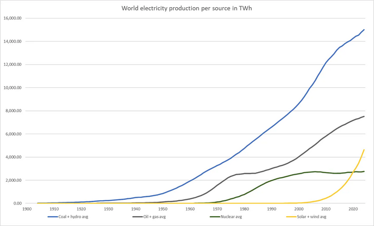
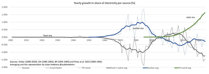
Solar by the numbers. The solar age is here. https://aukehoekstra.substack.com/p/the-coming-solar-era-in-numbers
-
8 more weeks until the average temps start falling back. July and August are the worst. Bees, snakes, mosquitoes, ticks, and spiders rule the next 2 months. Who said Summer is fun?
-
The storm formation and movement is an interesting scenario for this area. It's very similar to the summer monsoon pattern in Arizona. Storms from in the mountains north of Phoenix, and then slowly drift south towards the metro area. Often times out there, however, that drift is new storms forming on the outflow boundaries, but still...
- Today
-
Hazardous Weather Outlook National Weather Service State College PA 439 AM EDT Thu Jun 12 2025 PAZ004>006-010>012-017>019-024>028-033>037-041-042-045-046-049>053- 056>059-063>066-130845- Warren-McKean-Potter-Elk-Cameron-Northern Clinton-Clearfield- Northern Centre-Southern Centre-Cambria-Blair-Huntingdon-Mifflin- Juniata-Somerset-Bedford-Fulton-Franklin-Tioga-Northern Lycoming- Sullivan-Southern Clinton-Southern Lycoming-Union-Snyder-Montour- Northumberland-Columbia-Perry-Dauphin-Schuylkill-Lebanon-Cumberland- Adams-York-Lancaster- 439 AM EDT Thu Jun 12 2025 This Hazardous Weather Outlook is for central Pennsylvania. .DAY ONE...Today and tonight. A few strong thunderstorms containing small hail and gusty winds will likely form across the Northern Mountains of the state this afternoon and drift slowly south across the Central Mountains, Middle Susquehanna Valley and Western Poconos late today and this evening. .DAYS TWO THROUGH SEVEN...Friday through Wednesday. Several rounds of slow-moving showers and thunderstorms with locally heavy rainfall will occur Friday night through Sunday and could result in an increasing threat for flash flooding of small streams, creeks and poor drainage areas. The greatest risk for flash flooding will likely be late Saturday and Sunday. The southern portion of the state and areas of complex terrain will be especially vulnerable given enhanced rapid runoff with heavy rainfall.
-
Congrats! Diet Cokes 4 Eva!
-
Maybe one of you northern readers will get lucky.

-
Congrats!
-
Well I'm calling it quits from the rat-race today. Time to enjoy some retirement/semi-retirement.
-
We had a little rain tonight. We probably got a quarter inch. However, Dallas is on their fourth night of torrential rain. Houston is lighting up, too. North Texas will be severely smashed by torrential rain overnight and all day Thursday with no mercy. There will be thousands of water rescues on the Trinity River. Houston is going to get severely flooded well into the day today. We do not flood here in Austin. All we have are droughts, and Lake of Fire HEAT. This is a La Nina year. Austin will be dry. Austin will be extremely hot. There will be little rain, unless you reside in Dallas, Houston or East Texas. This upcoming cool season will remail dry as hell. BUT FIRST we gotta get thru this weekend. Mark Saturday, June 14 on your calendars!! That's all I can say. This weekend is gonna be something else. Austin not getting substantial rain in this drought is the LEAST of our problems.
-
-
-
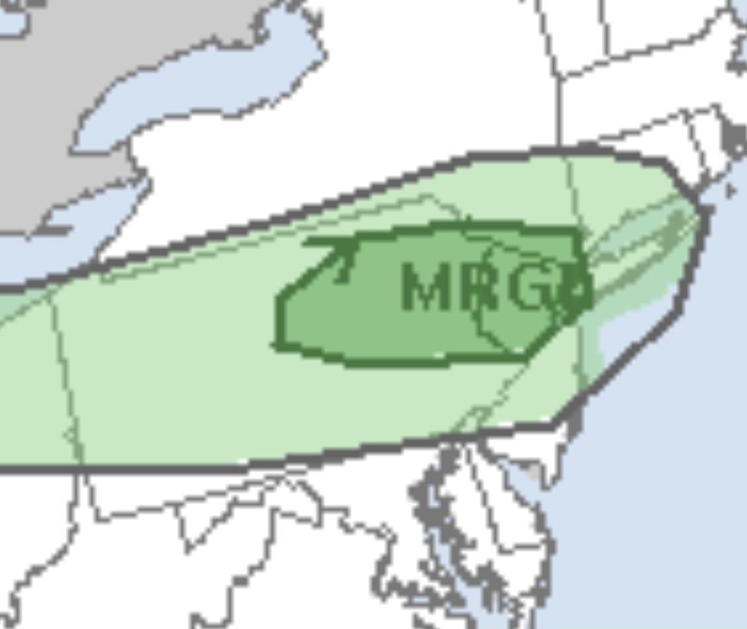
We are monitoring a possible increase in severe storm probs for Thursday afternoon and evening; we spoke with the SPC concerning a categorical upgrade to MRGL (level 1) severe storm risk. The last 2 runs of the HREF indicate moderate destablization overlapping with favorable deep layer shear on the southern periphery of stronger west-northwest flow aloft. Limiting factors at this stage include displacement of best lift (well to the north) and weak convergence along the southward moving cold front - which reduces confidence to some extent. We would anticipate at least a MRGL risk on day 1 if a stronger signal for robust development emerges with time. PWATs continue to trend higher into Friday ~1.5" with a good signal for scattered showers and storms particularly across south central PA into the Susquehanna Valley. Cloud cover and weak low passing by to the southeast could limit instability over most of the area with the synoptic setup favoring some locally heavy/slow moving downpours. Cloudy and foggy conditions expected Friday night with some scattered rain showers hanging around into Saturday morning.
-
StaminUP
-
 nagoti joined the community
 -
Brian Wilson died I'm telling you and everyone else, anyone who thinks the people who perform today (sports, art, whatever) are better than they were, hasn't listened to the songs Brian Wilson wrote or performed. There is NO ONE today who was as talented as he was, and right from the age of 19 when he created The Beach Boys.
-

2025 Lawns & Gardens Thread. Making Lawns Great Again
DavisStraight replied to Damage In Tolland's topic in New England
Only time I had water in my basement was in December one year where it was really cold for a good stretch then it rained hard, rain just stayed on top of the frozen ground and came in under my door. I waterproofed it after that and that was the last and only time. -
83 today, 65 now. Warm night
-
Are the doors unlocked when they get in or are they able to get in anyway?
-
lol JFK beats Central Park on a southerly wind..... nice
-
Went to Dupont today for the first time. Interesting place that doesn't fully seem like the high country but doesn't feel like the foothills.
-
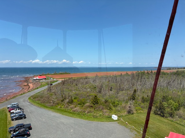
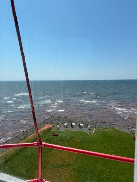
Day 2 in PEI. Beautiful day 70’s and sun.


.thumb.jpg.6a4895b2a43f87359e4e7d04a6fa0d14.jpg)