All Activity
- Past hour
-

The Monday wintry event potential (12/8/25)
olafminesaw replied to GaWx's topic in Southeastern States
From Raleigh N and East there may be a little wrap-around/back-building snow as well -
This is almost certainly survivorship bias. Few here might remember the string of runs from the Euro and GFS and their ensemble counterparts from the week before that, showing a massive overrunning event that fizzled out at medium range.
-
-
thoughts y'all? i'm not saying it'll happen or not i'm just curious and your takes
-
Coming back to cut off for any dusting on the grass or car tops is Northern Oxford .
-
I got them Lee Side Blues.
-
(002).thumb.png.6e3d9d46bca5fe41aab7a74871dd8af8.png)
Central PA Winter 25/26 Discussion and Obs
ChescoWx replied to MAG5035's topic in Upstate New York/Pennsylvania
You can tell things have slowed down with my business as we near the holidays....plenty of time for some updated analysis! Below are the Top 10 snowstorms since January 1, 2020 here in East Nantmeal Township. We have had 5 storms greater than 6 inches but only 2 storms that have exceeded 10" or more.
-
E PA/NJ/DE Winter 2025-26 Obs/Discussion
ChescoWx replied to LVblizzard's topic in Philadelphia Region
You can tell things have slowed down with my business as we near the holidays....plenty of time for some updated analysis! Below are the Top 10 snowstorms since January 1, 2020 here in East Nantmeal Township. We have had 5 storms greater than 6 inches but only 2 storms that have exceeded 10" or more.
-

December 2025 regional war/obs/disco thread
TheSnowman replied to Torch Tiger's topic in New England
Does Everyone REALIZE that Tomorrow is the 20th Anniversary of the Most Impressive Snowstorm in recent History around SNE? December 9th, 2005 I had 2 Thundersnow hits including 1 Lightning Bolt in the woods Right behind me. 12” Total. 3” per hour for 2.5 hours. -
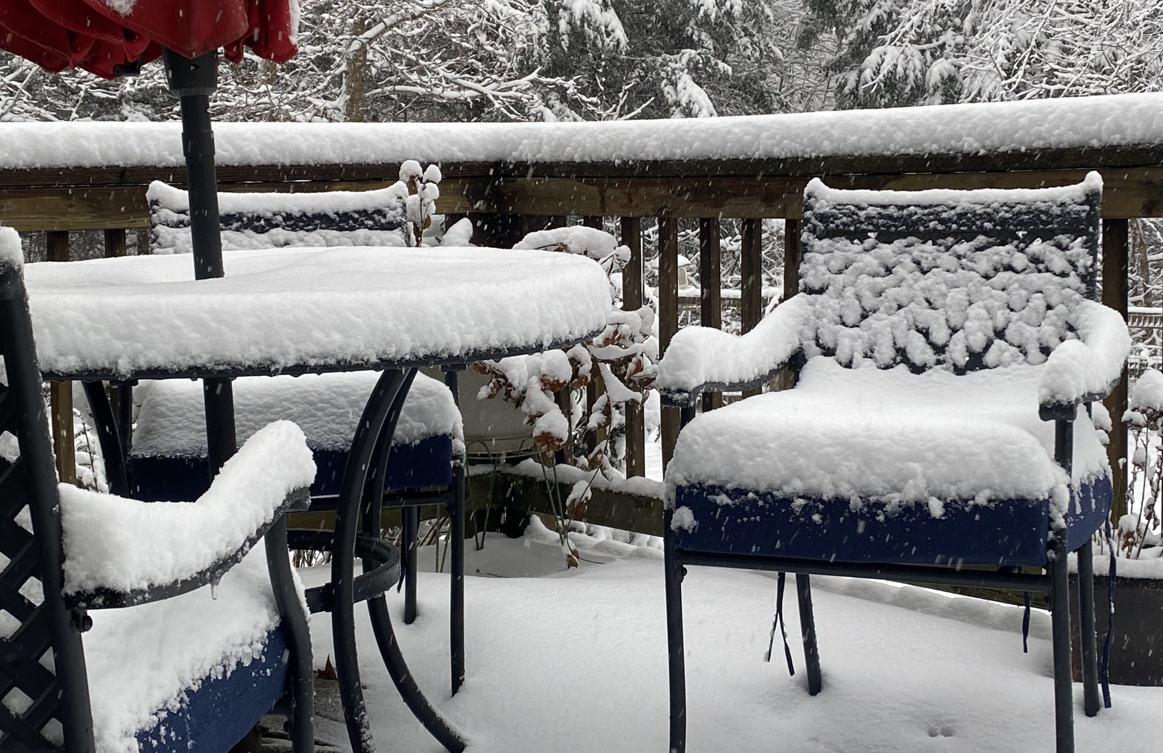
The tone today is a monotone snow weenie sigh under our thin cirrus deck while SE VA gets their 2nd snowstorm in a week.
-

December 2025 Short/Medium Range Forecast Thread
Carvers Gap replied to John1122's topic in Tennessee Valley
I don’t buy the 12z EPS right now. It has no support from its deterministic model and has been wrong for several weeks in trying to slide a permanent ridge into the east. I think a ridge is coming but more likely around the 20th. I can’t tell if it just rolls through or is a pattern change. I could be wrong, but I think we are good through the 18th with possibly one more trough after that before we get a break. -
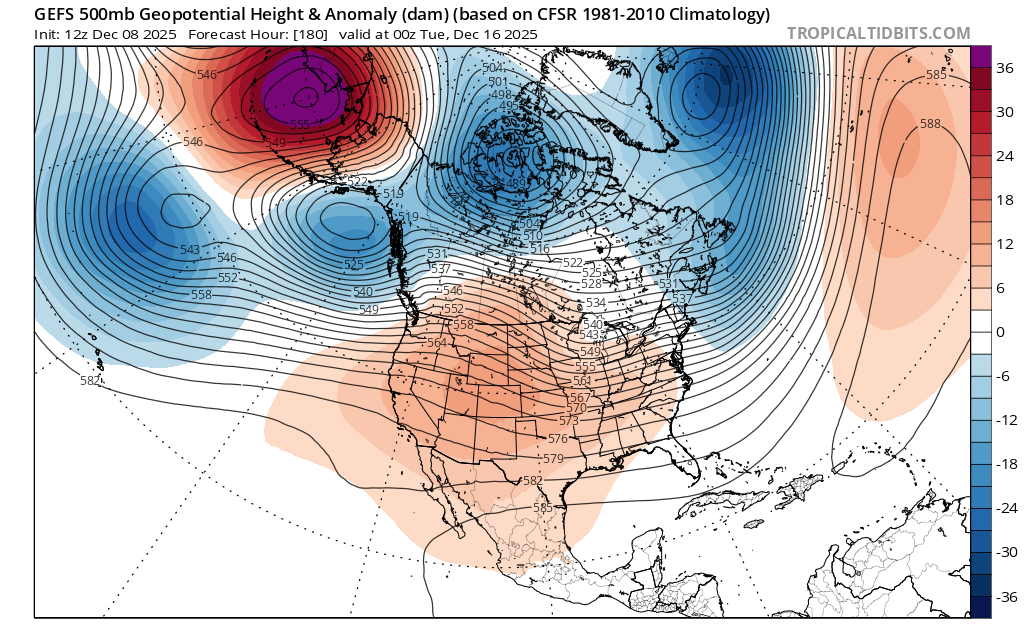
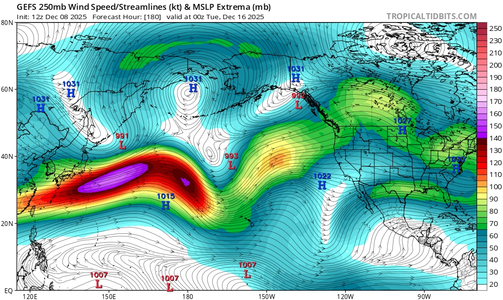
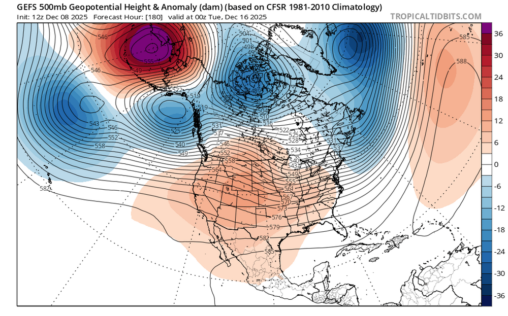
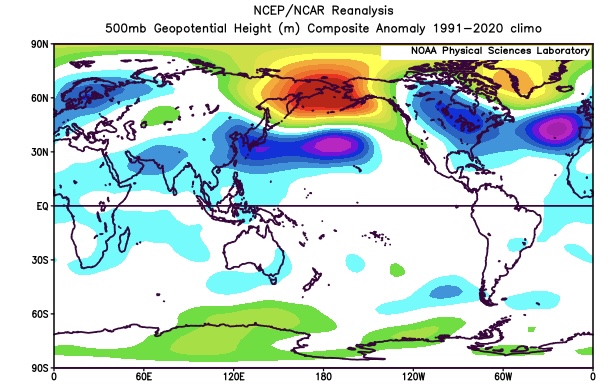
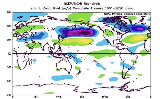
I suspect that the issues the models have been having long range are related to the much faster Northern Stream of the Pacifc Jet which continues. It’s not typical to get a strong -WPO +EPO couplet at the the same time in December. So the shortwaves in the fast Pacific flow are lowering heights over Eastern Alaska while the -WPO ridge stands firm. At least into mid December the +EPO and stronger Pacific are trying to have the ridge roll out into the Plains while the -WPO would have the ridge axis more in the West. So a tug of war between two competing influences that we normally don’t see at the same time. My guess is that the ridge eventually comes east at some point during the 2nd half of December as the Pacific Jet eventually wins out in these situations. Notice how the 10 year December strong -WPO composite features a more -EPO and a relaxed Pacific Jet. Much stronger Pacific Jet and unusual +EPO in mid-December for a very strong -WPO block Past 10 strongest December 500 mb -WPO blocks didn’t have to compete with such a strong Pacific Jet and +EPO

-
Is this RIC or ORF?
-
December 2025 Short/Medium Range Forecast Thread
Carvers Gap replied to John1122's topic in Tennessee Valley
Interestingly, the Euro Weeklies control and ensemble are exactly opposite again. Last time, the control won that battle. The control is 30 day strong trough. As for the MJO, there is some activity in 7-8-1-2. This morning it began the anticipated loop/stall in 8. I have little doubt the convection forecast for 1-2 will eventually propagate into 6. It looks to me like that will happen sometime in the third or fourth week of December. It could be earlier. Currently the MJO plot is in 8 and the atmosphere reflects that with an eastern trough in place and eastern troughs forecast through roughly Dec 20. Again, it is early December. This is not snow climo for valley locations. -
Eps totally screwed mby with the snow to rain threat last week with 5" 4+ days out, 3" the day before and 2"+ on the 6z run the morning of the event v only to get close to 3/4" snow and sleet. I guess it's me, but the Eps are always wrong with accumulations imby.
-
Temps dropping and moderate snow... that's the dream combo!
-
-

Richmond Metro/Hampton Roads Area Discussion
chris624wx replied to RIC Airport's topic in Mid Atlantic
Nothing crazy, but should be a little as the low pulls away -

Richmond Metro/Hampton Roads Area Discussion
EverythingisEverything replied to RIC Airport's topic in Mid Atlantic
Va. Beach was a mix, but hard to see flakes at the moment. -
-
Richmond Metro/Hampton Roads Area Discussion
snowchill replied to RIC Airport's topic in Mid Atlantic
4” Powhatan
-
Are the models showing some good enhancement?
-
Newport news
-
High here was 26.6° after midnight…afternoon high 16.7°. It’s already down to 14.8°…chilly late afternoon.
-
5-6” by NWS AKQ when all is said in done I think. 4” now. Just tip your cap.