All Activity
- Past hour
-

September 2025 OBS-Discussion centered NYC subforum
STORMANLI replied to wdrag's topic in New York City Metro
0.69" -
You love to see it

-

September 2025 OBS-Discussion centered NYC subforum
psv88 replied to wdrag's topic in New York City Metro
0.46. Those 3” totals are not happening -

September 2025 OBS-Discussion centered NYC subforum
SACRUS replied to wdrag's topic in New York City Metro
Sep departures (thru 24) 7 EWR: +0.5 NYC: -0.4 JFK: -0.7 LGA: -1.2 -
September 2025 OBS-Discussion centered NYC subforum
SACRUS replied to wdrag's topic in New York City Metro
what should become Imelda looks to stay along the EC (where is the key) next week and dump some serious rains -
Drive from E CT to Providence was pretty bad.
-
0.34". Sent from my SM-S921U using Tapatalk
-
With a potential for a hit between Savannah and Wilmington NC it might be time for a road trip up to East Hartland, maybe it’ll be like Erin which gave us the most amazing un-South Carolina like summer weather after it passed OTS with temperatures in the upper 70s and low 80s with low humidity for weeks.
-

2025-2026 Fall/Winter Mountain Thread
Rainforrest replied to Buckethead's topic in Southeastern States
Picked up 1.50” since yesterday afternoon. -

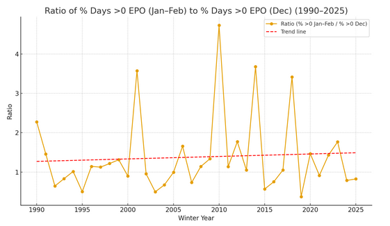
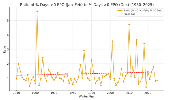
2025-2026 ENSO
donsutherland1 replied to 40/70 Benchmark's topic in Weather Forecasting and Discussion
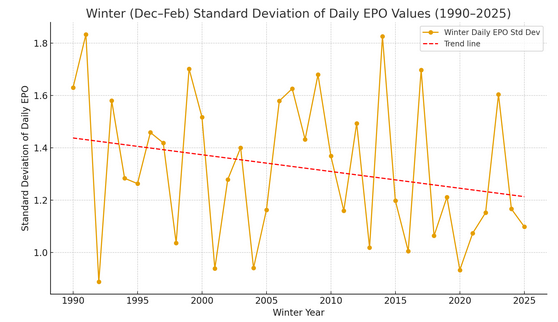
With regard to the EPO, I suspect the current issue is less one about whether it can go positive or negative, but the issue of decreasing variability. In other words, there is greater stickiness for either a positive regime or negative regime during winter and that tendency has increased in recent years. More broadly, this tendency would be consistent with the growing evidence that "stuck patterns" are growing more frequent. And if one looks more closely, the stuck patterns seem to be starting to break in favor of EPO+ values. Here are ratios of the percentage of postive and negative days in January-February vs. percentage of positive and negative days in December. These are currently modest trends.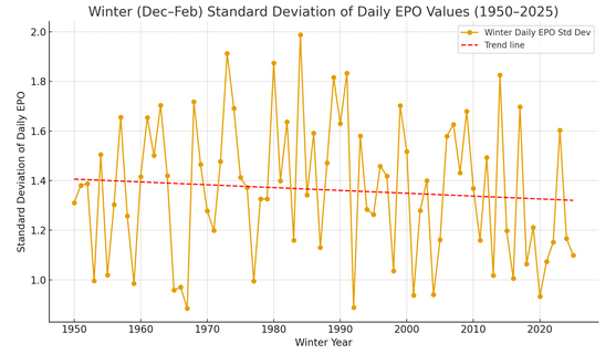
-
Effing gyre ftl.
-

September 2025 OBS-Discussion centered NYC subforum
Brian5671 replied to wdrag's topic in New York City Metro
A little better than last year where we went 2 months without anything at all. But yeah, can't buy a good soaking -
Model trends can shift fast, especially on Signal Mountain. Afternoon storms are tricky, so I’d watch hi-res radar updates closely around midday.
-
 Reposting here.
 -
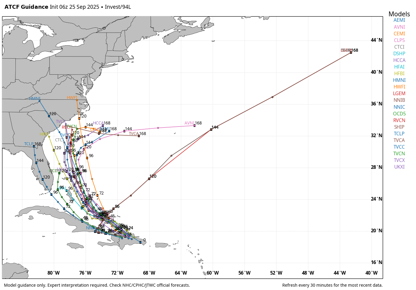
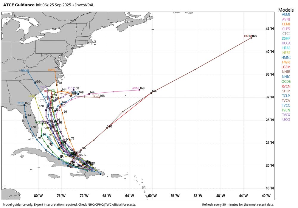
I now believe that Invest 94L is a bona fide threat to the U.S. East Coast. Still, there is enormous uncertainty regarding the intensity and track of what is likely to become Imelda in the coming days. First, let's take a look at Humberto, which will play a critical role in the track of 94L. Although still sheared with the center likely west of the deeper convection, this tropical storm is on a clear organizing trend. The spacing between Humberto and 94L has been a point of discussion for days now. How close these two get will determine whether there will be a binary interaction. The GFS, which after sniffing out the potential for TC development in the SW Atlantic then kind of got lost in trying to consolidate the two waves, has clearly trended toward the Euro--to the extent you can with this much uncertainty in the setup. These are the last 5 GFS runs. Note how the trend has been two-fold. First, there is the obvious change that makes 94L stronger. That decreases the likelihood that it is absorbed by Humberto and given an escape route OTS. The second change is the spacing. It's subtle, but can be seen easily. A stronger and more organized 94L would likely have the outflow necessary to keep Humberto at bay. On the Euro, you see a similar trend with regard to spacing. Note how the escape routes of 1) Humberto and 2) NW flow in New England and SE Canada are blocked. These are the last 3 runs--not including this morning's 06z op run which continues the trend. The spacing difference is more than enough here to limit the impact of Humberto. Are we guaranteed a SE coast hit? Not at all. There are a lot of nuances remaining, including how quickly Humberto intensifies and its forward speed, the amplitude of the ridge and how it develops, and the amplitude of the cutoff over the CONUS. It is very clear, however, that 94L is poised to develop, and it poses a risk to at least the SE coast with regard to a direct hit, with possible impacts further north depending on track.
-
Morning AFD from LWX already mentioning PRE potential .SHORT TERM /FRIDAY THROUGH SATURDAY NIGHT/... The cold front looks to sit just east of the Chesapeake Bay Friday morning. A few lingering showers may be possible for areas east of I- 95 and down across southern MD and the northern neck of VA. Clouds will gradually thin with filtered breaks of sunshine, especially later in the day and in areas mainly north of I-66/US-50. The front itself will continue toward the Delmarva coast before stalling into the upcoming weekend. With the frontal zone nearby expect continued scattered shower chances in areas south of I-66 (central VA Piedmont) Friday afternoon into Friday evening. High temperatures Friday will push back into the upper 70s and low 80s (upper 60s and low 70s mountains). Overnight lows Friday night will fall back into mid to upper 50s west of I-81 with low to mid 60s further east. Surface high pressure tries to build back into the region from the Great Lakes and Ohio River Valley. Meanwhile, a stalled frontal boundary will remain in the vicinity of the lower Delmarva coast and Carolinas with an upper level low pressure system cutoff within the mean flow over the southern Appalachians. In addition to this Tropical Storm Humberto will continue further north toward the Bahamas and southeast U.S coast late Saturday into Sunday. The interaction amongst all these surface/upper level features could lead to a pseudo PRE event across portions of the Mid-Atlantic region as early as Saturday night into Sunday morning. Lots of uncertainty remains in regards to where this event will occur given the interaction and overall placement of the aforementioned features above. The dynamics are there though given the approaching upper level trough and surface cold front, low pressure to the south, and influx of tropical moisture along the stalled boundary at the coast. Something that will have to continue to monitor in the coming days ahead. Either way if this were to occur we could be looking at drought busting rainfall for much of the region to round the weekend into early next. Highs Saturday will range from the mid to upper 70s over central and northeast MD to mid 60s and low 70s over the mountains/Shenadoah Valley. Lows Saturday night will fall back into the upper 50s and low 60s. && .LONG TERM /SUNDAY THROUGH WEDNESDAY/... UL troughing and an associated cut-off ULL over the southern Appalachians will meander over the same general area through much of the long term. For Sunday, rather interesting set up with some model guidance and ensemble suites starting to hint at a pseudo PRE event with heavy rain in the Mid-Atlantic. Lots of uncertainties wrt placement and actual occurrence, but dynamics are there: approaching trough and sfc cold front with UL right entrance of jet streak, some MUCAPE with low-level stability, and near record PWs. Depending on timing may start before sunrise Sunday, and go into Monday, but something to keep an eye on. Thereafter, attention turns to the tropics and how Tropical Storm Humberto interacts with invest 94L and the trough across the eastern CONUS. Lots of uncertainties and NHC has the latest official forecast at hurricanes.gov. Temperatures will be in the 70s each day with higher elevations staying in the 60s. Overnight temperatures will be in the 60s for those east of the Blue Ridge and 50s for those along and west.
-

2025-2026 ENSO
PhiEaglesfan712 replied to 40/70 Benchmark's topic in Weather Forecasting and Discussion
The last wall-to-wall -EPO -WPO pattern was in 2013-14 and 2014-15, correct? -
September 2025 OBS-Discussion centered NYC subforum
SACRUS replied to wdrag's topic in New York City Metro
Records: Highs: EWR: 91 (1970) NYC: 90 (1970) LGA: 90 (2010) JFK: 87 (2010) Lows: EWR: 39 (1950) NYC: 40 (1887) LGA: 42 (1950) JFK: 45 (1989) Historical: 1848 - The Great Gale of 1848 was the most severe hurricane to affect Tampa Bay, Florida and is one of two major hurricanes to make landfall in the area. This storm produced the highest storm tide ever experienced in Tampa Bay when the water rose 15 feet in six to eight hours. 1848: The Tampa, FL area was hit by a major hurricane. The pressure plunged to 28.18 inches of mercury and the storm surge reached 15 feet. The army post in the area was wiped out. (Ref. Wilson Wx. History) 1926: The coldest temperature ever recorded in Scottsbluff, NE for the month of September occurred on this with a low of 14°, while Chadron, NE recorded their lowest September temperature with 15°. Western Yellowstone, MT recorded -9 °F which was then the lowest temperature reading in the 48 states for September. (Ref. AccWeather Weather History) 1929: Willmar, MN experiences a deluge that dropped 5.22 inches of rain in 24 hours. (Ref. AccWeather Weather History) 1939 - A west coast hurricane moved onshore south of Los Angeles bringing unprecedented rains along the southern coast of California. Nearly five and a half inches of rain drenched Los Angeles during a 24 hour period. The hurricane caused two million dollars damage, mostly to structures along the coast and to crops, and claimed 45 lives at sea. ""El Cordonazo"" produced 5.66 inches of rain at Los Angeles and 11.6 inches of rain at Mount Wilson, both records for the month of September. (David Ludlum) (The Weather Channel) 1942: The earliest first trace of snow in Chicago occurred on this date in 1942 and 1928. First snow of the season Average; October 30 Earliest; September 25 (1928 and 1942) Latest; December 5, 1999 First measurable snow (.1 inches or more) of the season Average; November 16 Earliest; October 12, 2006 Latest; December 16, 1965 Snow Trivia for Chicago - NWS 1953: The center of Hurricane Florence hit the northwest Florida coast between Valparaiso and Panama City near midday with wind maximum sustained winds near 80 mph with gusts to 90 mph and heavy rainfall. The Pensacola Weather Bureau Office reported winds of up to 75 mph early the next morning. The storm passed inland over a sparsely settled area of Florida and this probably accounts for the rather small amount of damage. In Franklin and Okaloosa Counties the Red Cross estimated that 273 homes were destroyed, 145 other buildings damaged, and three destroyed. A fishing trawler, the "Miss Tampa" was reported missing in the storm's wake. (Ref. Wilson Wx. History) 1962: The remnants of Tropical Storm Claudia of 1962 dumped up to 7 inches of rain in the desert west of Tucson, AZ, causing severe flooding. By the year 2010 there had already been six storms by the name of Claudia. (Ref. Wilson Wx. History) 1975: On September 25 and 26 Elloise gave Hayfield secondary School 5.58 inches rain that closed Fairfax County schools September 26th 1975. The remnants of Hurricane Eloise combined with a cold front and produced very heavy rainfall in the Mid-Atlantic. Washington, DC reported 9.08" of rainfall. Total damage for Virginia was estimated to be $17.2 million. (Ref. Washington Weather Records - KDCA) 1976: Up to 3 inches of rain fell on Tucson, Arizona. About a dozen cars, some occupied, were swept down the washes, resulting in one death. Two boys were carried down the Rillito River for a mile before they could reach ground after their car was swept away. Talk about lucky! (Ref. AccWeather Weather History) 1984: Sheridan, WY recorded their coldest September temperature on record when they fell to 6°. 21 inches of snow fell at Sheridan between the 23rd and the 27th. This made it their snowiest September on record. Other record lows included: Cheyenne, WY: 17°, Casper, WY: 20° and Rapid City, SD: 24°. (Ref. Wilson Wx. History) 1987 - Hurricane Emily crossed the island of Bermuda during the early morning. Emily, moving northeast at 45 mph, produced wind gusts to 115 mph at Kindley Field. The thirty-five million dollars damage inflicted by Emily made it the worst hurricane to strike Bermuda since 1948. Parts of Michigan and Wisconsin experienced their first freeze of the autumn. Snow and sleet were reported in the Sheffield and Sutton areas of northeastern Vermont at midday. (The National Weather Summary) (Storm Data) 1988 - Low pressure off the Northern Pacific Coast brought rain and gale force winds to the coast of Washington State. Fair weather prevailed across most of the rest of the nation. (The National Weather Summary) 1989 - Twenty-three cities in the south central U.S. reported record low temperatures for the date, including Topeka KS with a reading of 33 degrees, and Binghamton NY with a low of 25 degrees. Showers and thunderstorms in the southeastern U.S. drenched Atlanta GA with 4.87 inches of rain, their sixth highest total of record for any given day. (The National Weather Summary) (Storm Data) 1993: In both human and economic terms the Great Flood of 1993 was the most devastating in modern U.S. history. It was a catastrophe across portions of 9 states with losses estimated up to $20 billion dollars. Over 50,000 homes were damaged or destroyed forcing the evacuation of some 54,000 people. In all the floods took 50 lives. Water level records were set at 49 places on the Missouri River system and at 43 places on the upper Mississippi River system. The flood was notable for its duration as well as its size. Flooding began in March with record floods beginning in May and continued into September. (Ref. Wilson Wx. History) 1994: Hail to 1 inch diameter was pounding Hebron, NE. A man ventured out into the storm to release a dog tied to a tree. Lightning killed the man and injured a woman at the scene. The dog was unhurt. (Ref. Weather Guide Calendar with Phenomenal Weather Events 2011 Accord Pub. 2010, USA) 1996: An early season snowstorm brought the season’s first snow to the Front Range eastern foothills in northern Colorado. Heavy snowfall totals included: 8 to 12 inches near Conifer, 7 inches at Floyd Hill, 6 inches at Bailey & Chief Hosa and 4.7 inches at Denver. Heavy rain fell in the Blackwell area of north-central Oklahoma beginning the previous day through this date, causing many roads to be closed. National Weather Service radar estimated that more than three inches of rain fell in less than 90 minutes in central Kay County, late in the evening. The two day rainfall in Blackwell totaled 9 inches. (Ref. Wilson Wx. History) 1998: By the 5 PM ET advisory, 4 hurricanes were spinning simultaneously in the Atlantic basin: Georges, Ivan, Jeanne, and Karl. That was the first time this had happened since 1893. After moving along the north coast of Cuba the previous day, Georges crossed the Florida Keys, heading into the Gulf of Mexico. The storm had re-intensified with winds of 105 mph when it made landfall near Key West, FL midday. (Ref. AccWeather Weather History) 1998 - Four hurricanes were spinning simultaneously in the Atlantic basin: Georges, Ivan, Jeanne, and Karl. That was the first time this had happened since 1893. 2004: Jeanne after performing a complete loop over the open Atlantic, it headed westwards, strengthening into a Category 3 hurricane. Jeanne passed over the islands of Great Abaco and Grand Bahama in the Bahamas on September 25. Jeanne made landfall later in the day of the 25th in Florida just 2 miles (3 kilometers) from where Frances had struck 3 weeks earlier. Building on the rainfall of Frances and Ivan, Jeanne brought near-record flood levels as far north as West Virginia and New Jersey before its remnants turned east into the open Atlantic. Jeanne is blamed for at least 3,006 deaths in Haiti with about 2,800 in Gonaïves alone, which was nearly washed away by floods and mudslides. The storm also caused 7 deaths in Puerto Rico, 18 in the Dominican Republic and at least 4 in Florida, bringing the total number of deaths to at least 3,025. Final property damage in the United States was $6.8 billion, making this the 13th costliest hurricane in U.S. history. Hurricane Jeanne's Track - Weather Underground (Ref. More on Hurricane Jeanne) -
Chance of maybe an isolated spinner today? Morning AFD from LWX The first wave of showers and thunderstorms look to exit mid to late morning allowing the atmosphere to reload for the afternoon and evening ahead. Some uncertainty remains into how much clearing that we do see given the morning activity and incumbent trough/surface cold front nearby. Even with that said, the added lifting mechanism of the trough/front and leading shortwave energy should aid in higher convective chances this afternoon. The Storm Prediction Center has a Marginal Risk (Level 1 out of 5) for severe weather today east of the Allegheny Mountains. The main threat is damaging winds and heavy rainfall with a secondary threat of an isolated tornado. CAPE values look to sit between 1000-2000 j/kg with deep layer shear around 40 to 50 kts. This should lead to some organization if storms are to materialize (i.e line segments or even a supercell or two). The NAM3km/NSSL/ARW remain the aggressors when it comes to curved hodographs with 0-1 SRH values up around 200-250 m2/s2. The RAP/HRRR show less values and less of a curved signature. With that said, the tornado threat would remain isolated (i.e via supercell or most likely in a QLCS type of scenario) with a focus east of US-15. Greatest concern for severe weather if it were to occur would be between 4-8pm as the front crosses. Once again the threat will be highly dependent upon cloud cover and how quickly things can reload after this morning`s rainfall. Afternoon high`s will reach into the upper 70s and low 80s (upper 60s and low 70s mountains).
-
.07 If you only went by how soggy it is out there right now you'd think it was inches... The raspberries are loving it though
-
Congratulations on reaching a milestone in your life!!
-

E PA/NJ/DE Autumn 2025 Obs/Discussion
Lady Di replied to PhiEaglesfan712's topic in Philadelphia Region
I'm pretty old and don't recall a tropical set up like this. It will be really interesting to watch. Really humid and gross out. -
WB 6Z tracks.
-
I wouldn't look at the verbatim output seriously yet. Look at the upper level pattern.
-
September 2025 OBS-Discussion centered NYC subforum
SACRUS replied to wdrag's topic in New York City Metro
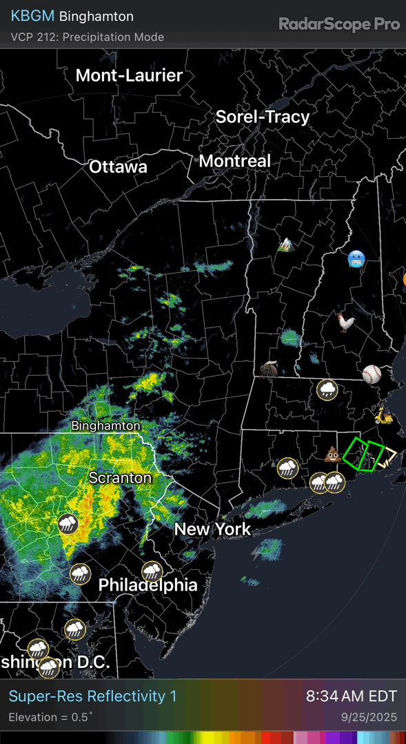
73 / 71 cloudy some light showers 0.20 in the bucket. Clouds sticking around much of the next few days with Friday the exception. Warm / humid some additional rain later today and then on Sunday. Eyes turn to Imelda and Humberto with Imelda the EC risk. Overall warm beyond the twin tropics in the 10/3 period and beyond.