All Activity
- Past hour
-
https://x.com/MaxVelocityWX/status/2071655454279680226 Impressive!
-
Dew hit 79 here and at MLI today. Didn't feel too bad though with the 30mph winds. MLI only made it down to 78 degrees this morning.
-
Thanks Cape, " I just tell it like it is" is a perfect description of your style. Do you believe that you may be better off not" tellin it like it is". What is wrong with a decent poster who does not tell it like it is?? A "tell it like it is bastard" is not popular with intelligent people. Why can't you allow people who you don't agree with to go on their way without a snarky attack. If they make a totally inaccurate allegation, correct it and move on without insults. And , yes, your mental issues are probably a lifelong trait
-
It's probably meaningless of course but ... see the whack Euro at the end of that run? wtf chuck. 600+ ridge with a 582 bone chilling trough of NE and the OV. we've been up near 100 deg at 582 hgts.
-
A warming trend is under way. The warmth will continue to build through the remainder of June before culminating in a severe heatwave to start July. The heat could rival that of early July 1966. Much of the region will likely experience its highest temperatures so far this summer with maximum temperatures peaking in the 100°-105° range. Some locally hotter temperatures are possible. Most of the Mid-Atlantic and southern New England areas will see temperatures reach 100° or above during the height of the heatwave. Boston, Burlington, Philadelphia and Washington, DC could challenge their all-time records. The ENSO Region 1+2 anomaly was +3.1°C and the Region 3.4 anomaly was +1.8°C for the week centered around June 24. For the past six weeks, the ENSO Region 1+2 anomaly has averaged +2.60°C and the ENSO Region 3.4 anomaly has averaged +1.37°C. The ongoing El Niño will continue to strengthen through the summer. The SOI was -13.64 today. The preliminary Arctic Oscillation (AO) was +1.326 today. Based on sensitivity analysis applied to the latest guidance, there is an implied near 100% probability that New York City will have a warmer than normal June (1991-2020 normal). June will likely finish with a mean temperature near 73.2 (1.2° above normal). Supplemental Information: The projected mean would be 1.8° above the 1981-2010 normal monthly value.
-
Over the years Ive read/seen numerous long range pre winter forecasts predicting a major snowstorm in February ...some have even gone out on a limb and predicted the weather will warm in March......
-
 Please change thread title to either Julorch or Julace .
 -
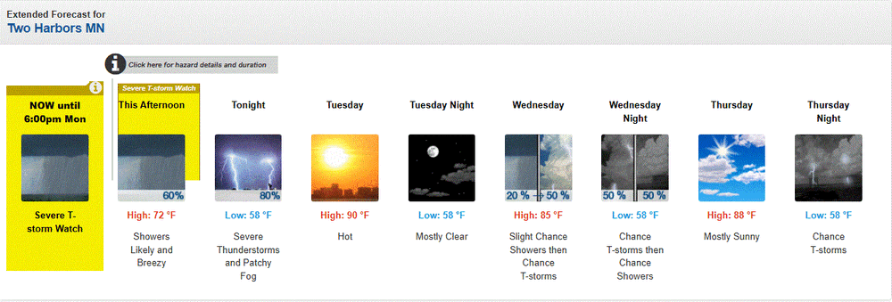
Lucky! At least you get to cool down to 58 every night. Further south here it won’t dip below 75 at night this whole week.
-
I find the argument over how to measure temperature so interesting. A big point of my climate near the ground course was the idea of what makes a measure standard and for who is that standard useful. For instance, we take the 2m shade as our “normal” temperature measure. Yet, conditions near the ground are almost always subadabatic during daytime conditions and can be several degrees (even 10+ in extreme circumstances!) degrees C warmer closer to 1m and below. Not to mention we take the shaded measurement when midday in most environments (besides forest) sun is dominant. We also try to control environments to be flat and clear; meanwhile, the majority of lived places aren’t that! Of course, the 2m shade/open areas are the standard due to it accounting for variables, but too often we forget those complications exist in the first place. Makes me wonder if there should be “real feel” weather stations say 1.5m on the street of NYC or DC where people actually experience weather to best capture the experience of how weather impacts people.
-
What???
-
https://x.com/spann/status/2071707754075427175
-
It's the overnight temps that bake us. Down south 95/75 or more for months was the norm. But even down there when we had a stretch of night time lows over 80 with dews riding just below the temps it was considered kind of like a heatwave. 25 miles inland and east into central SC is BRUTAL this time of year with Colombia often being the highest temp in the country. I was inland SC when it was 110/87 back in 2012. I mean you couldn't freakin' breathe and I was used to the heat. No breeze at all in those parts lol. This will be good prep for my trip, although I have lived up here long enough that what use to be normal heat for me is pushing it. The big cities in the East are in for it I fear.
-
Just picked up a quick inch with severe warned storm that popped up. A small break in the heat for this week.
-
After today's heavy rain, going to be ugly the next 3 days.
-
91 today
-
Heavy rains this aftrn. Looks like 2-3" around here. That was most welcome.
-
A+!
-
Ray?
-
speaking of... https://x.com/McMillinWx/status/2071645751982141741
-
Still going. About to take on the upper peninsula.
- Today
-

Summer 2026 Med/Long Range Discussion
BeastFromTheEast replied to Brian D's topic in Lakes/Ohio Valley
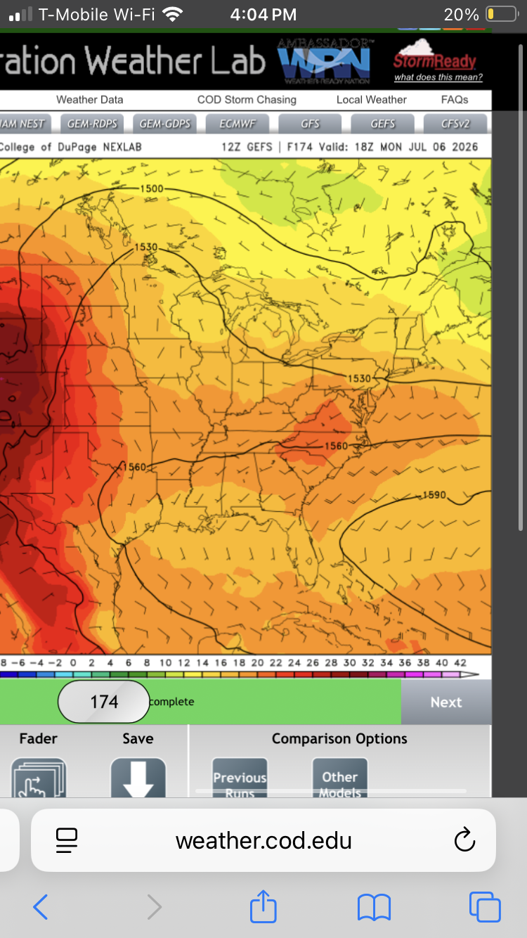
12Z GEFS has seasonal temps/heat after this current blowtorch concludes. It’s selling this look July 6th all the way till the end of the run. I see a lot of low-mid 80s high temps ahead, which I don’t think anyone will complain about.

-
Well…the big heat (90+ for me) doesn’t start until 7/1. But tip o the cap to CT Blizz and the others who forecast a bump in temps. today and tomorrow are awesome.
-
My favorite pre winter prediction is when someone predicts there will be a major snowstorm in February...
-
I'm consistently 'contributory', but you are entitled to your opinion. I won't comment on your value here......................................................... No kicks. I just tell it like it is. And my 'mental issues' have nothing to do with my age.
-
Fri-Sun (mostly Sunday) we picked up another 1.6". That puts us at 4.6" for the month of June. Have to go back to last August to see a higher monthly total. Hopefully that offshore lemon develops and gets July off to a good start.


.thumb.gif.f92b16c631a1d15d405ed77b33f0710d.gif)