All Activity
- Past hour
-

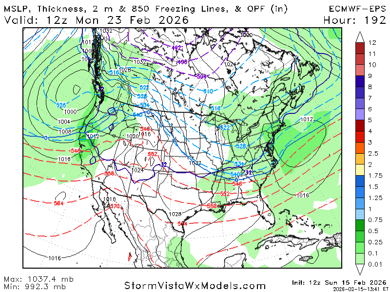
Late February/Early March 2026 Mid-Long Range
Ralph Wiggum replied to WxUSAF's topic in Mid Atlantic
Is there a minimum salary requirement to be able to post here? -
Bring it
-
And as far as I can tell, the intake for DC's water is up by Great Falls and none of the local counties use the Potomac for water from any point south of that. So, it seems like the sewage problem is gross, but is unlikely to affect much other than the handful of people who use the river for recreation.
-

Winter 2025-26 Medium/Long Range Discussion
frostfern replied to michsnowfreak's topic in Lakes/Ohio Valley
Local water levels are REALLY low here even with some snow melt now. I have former ponds in my area that are now meadows. -
Yea I can def point to better examples for down here than this one today. Not gonna lose sleep over it though - we had decent cold air in dec and jan, that wasn’t the problem, getting an active STJ is/has been.
-
Winter 2025-26 Medium/Long Range Discussion
frostfern replied to michsnowfreak's topic in Lakes/Ohio Valley
Lots of 1-2” snowfalls consisting entirely of dendrite aggregates seems to inflate totals because of extremely low water content. It counts, but it really doesn’t feel like as much as the numbers indicate. -
Quite a difference between Gefs/Geps and Eps at the end of their 12z runs. Eps being cool to seasonal w I th temps while Gefs/Geps are warm.
-
So it really looks like I will end up with just 7" (and half of that was sleet), even less snow than last year. And it's now a certainty that I end up with the 10th consecutive below normal snow winter in a row.
-
Looks like Tanning in Tolland today.
-
37 and rain in Deep Creek. Snowpack is taking a hit. Good thing I didn't plan on skiing today.
-

Central PA Winter 25/26 Discussion and Obs
Blizzard of 93 replied to MAG5035's topic in Upstate New York/Pennsylvania
Even after whatever table scraps we may get this evening, the 12z Euro & Euro AI say that the pattern through the end of this month looks to be active with a few Winter storm chances. -
-

-
First day of melting in the Berks since the big storm.
-

Central PA Winter 25/26 Discussion and Obs
Itstrainingtime replied to MAG5035's topic in Upstate New York/Pennsylvania
First sprinkles here at work. Temp is 42.6 to be precise. -
Basically downstream domino effect to put it simple as I'm sure you probably assumed anyway, lol. Doesn't always work but more times than not if that Depiction is realized. It's pretty obvious what can knock it off Kilter and we've addressed that before. Also, Model's, as has been the case quite alot lately, can be off on placement of those Features. Holston, man , we appreciate your analysis and input here more than you probably know. You are an unbiased, very knowledgeable Asset to the entire Forum . Top notch !
-

Central PA Winter 25/26 Discussion and Obs
pawatch replied to MAG5035's topic in Upstate New York/Pennsylvania
Have fun this afternoon. Then you get the banana up your tailpipe tomorrow Good Luck! 44 degrees currently…I’m ready to get back out fishing. Just need to get rid of the ice. -
Maybe you’re right I was mostly focused on this area up here. But there were examples recently for 95. One in 2021. Around the super Bowl. Perfect track little wave. I eeked out 6” of super wet snow up here and 95 was 34-35 during the heavy precip with white rain. They were in the cold sector. The boundary was juts 1-2f too warm. That was better example for 95. This one is a lost snow for up here
-
Whole city out
-
I don't have a problem with Euro's cyclone bombing on the 23rd because it doesn't actually hit anyone. That's the other tenor of the season. Anti-coastal coagulant
-
For your area and north of 70 for sure, but I don’t think even my area would have even been in play with 2-3f cooler temps
-
Approaching 30" is just a "little" over doing it so you'd be willing to trim that back, huh haha lord
-
Drought buster for Maine:
-
It depends where. Even in 1970 this was unlikely to be much snow south of DC and SE of the fall line. But even with this weaker low solution it’s close enough for places like Resiterstown, Frederick, Westminster, Parkton… I think it’s frankly a no brainer that these areas lost some snow. Was it 1” or 3” I dunno. But it’s so close that any colder at all would have made a difference. And we know it was colder. I don’t think it’s that complicated. And we know we are losing snow. The numbers bear it out. Our snowfall is declining. So we know for a fact we’re losing some storms. This one seems like a no brainer at least for my area. My wet bulb is 33. I’m going to he raining with a boundary layer of 33-34 for like 5 hours doing which about .3 qpf falls. That’s so marginal any colder at all and I’d be getting 2-3”. Maybe I do get 2” it’s close, but then any colder and it would have been 4”! Either way I am losing some snow today because it’s warmer. Because this is a perfect example of a borderline temp event where it’s going to tip barely too warm in 2026 and so likely would have tipped cold enough at some point in the past. I dunno if that point is 2000 or 1970 or 1950 or 1930 but at some point this would have been snow, at least up here.
-
I also wanted to shout out two archival sites that i use to gather additional records and reports for NJ/NY/MA. One is the big one everyone knows about Ray's Winter Storm Archive which is NJ NWS PHI focused. The other is also fantastic and it is NY Capital District/Catskills/Berkshires NWS ALY focused and that's Steve LaPointe's Weathernet6 Archive. He's got all major storms from 1993 to present and is very helpful with filling in reports from Berkshire, Dutchess, Ulster and Litchfield counties.


